Langley to Farnham Common
A leisurely walk (city/town) starting and finishing in Berkshire, England, about 9.40km (5.84 mi) long with an estimated walking time of about 2:45h. It is suitable for families with children, but unsuitable for prams & pushchairs, wheelchairs.
Elevation Profile
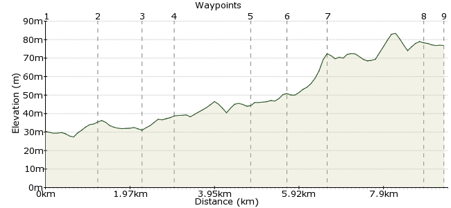
Ascent
54m (177ft)
Descent
7m (22ft)
Max. Elevation
90m (295ft)
Altitude Gain & Loss
61m (199ft)
Start
Langley Station
End
Farnham Common
Distance
9.40km
(5.84mi)
(5.84mi)
Duration
~2:45h
Difficulty
Leisurely
An easy walk through quiet lanes, a country park and some interesting woods. A good pub at the end. There's also a handy A&E if you injure yourself!
Walk Functions
Share
Nearby Walks
Langley to Hedgerley
A moderate, linear walk (countryside) starting in Berkshire, England, about 11.50km (7.15 mi) long, duration: ~3:30h.Iver To Staines
A moderate, linear walk (riverside) starting in Buckinghamshire, England, about 13.90km (8.64 mi) long, duration: ~4:00h.Stanwell to Sheperton
A moderate, linear walk (riverside) starting in Surrey, England, about 11.50km (7.15 mi) long, duration: ~3:15h.Walk Map
- $walk->POI array(0)
Waypoints
OS Grid TQ012797
Exit the station and turn north over the canal bridge. Once over the canal bear left into Trenches Lane. Continue straight ahead as this road becomes Love Hill Lane.
OS Grid TQ013810
At entrance to Langley Park turn left onto the footpath. Continue in a westerly direction across the park passing a lake. Eventually exit by some large gates onto Middle Green.
About 1.24 km (~0.77 miles) from 
OS Grid TQ003811
Bear right here and where lane turns sharp left continue straight along footpath. Eventually exit onto busy A412.
About 0.98 km (~0.61 miles) from 
OS Grid TQ003818
Cross road carefully and bear slightly right. walk down Wexham Park Lane until you see a footpath on your right. Take this path, where after a while it joins a crossing path. Almost immediately you meet a crossroad of paths. Continue straight ahead to pass behing Wexham Park Hospital
About 0.74 km (~0.46 miles) from 
OS Grid SU988826
Turn left along road and then shortly turn right onto a footpath across car parking areas. When you reach a footpath crossroads turn right and continue to Farthing Green Lane.
About 1.67 km (~1.04 miles) from 
OS Grid SU983834
Turn right onto Farthing Green Lane and and then after a short while turn left onto a footpath. Follow this path round to the right and continue on past a school. Emerge onto Hollybush Hill
About 0.89 km (~0.55 miles) from 
OS Grid SU985842
Turn left along Hollybush Hill and and the end of the road turn right. After a short while turn left along a path between some houses. When you emerge onto Duffield Lane turn left. When the land turns left, you turn right onto a footpath. Follow this path past Brockhurst Park and then through a large wood.
About 0.86 km (~0.53 miles) from 
OS Grid SU964848
When you emerge from the wood, go ahead between some houses. At the road turn right then left to arrive at Farnham Common. Reward yourself with a visit to the Stag & Hounds, which serves 10 real ales.
About 2.25 km (~1.4 miles) from 
 Farnham Common
OS Grid SU960850
Catch 74 bus back to Slough Railway Station
About 0.41 km (~0.25 miles) from 
