Y Garn from Llanelltyd
A moderate walk (mountain (above 600m)) in national park Snowdonia starting and finishing in Gwynedd, Wales, about 10.70km (6.65 mi) long with an estimated walking time of about 4:45h. It is unsuitable for families with children, prams & pushchairs, wheelchairs.
Elevation Profile
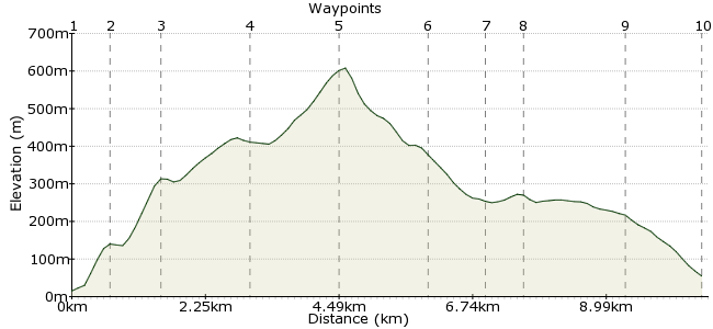
Ascent
600m (1968ft)
Descent
560m (1837ft)
Max. Elevation
610m (2001ft)
Altitude Gain & Loss
1160m (3805ft)
Start
Llanelltyd
End
Ganllwyd
Distance
10.70km
(6.65mi)
(6.65mi)
Duration
~4:45h
Difficulty
Moderate
Ordnance Survey Map
Y Garn is one of the smaller peaks in Snowdonia, certainly compared to the nearby Rhinogs and the giants in the north. But there is plenty of interest on this route, from the old farm buildings near Llanelltyd and beyond Y Garn's summit, and the impressive Rhaead Du waterfalls on the descent into Ganllwyd.
Walk Functions
Share
Nearby Walks
Mawddach Trail
A moderate, linear walk (riverside) starting in Gwynedd, Wales, about 12.40km (7.71 mi) long, duration: ~3:30h.The Mawddach Trail from Dolgellau
A strenuous, circular walk (low hills and fells (below 600m)) starting in Gwynedd, Wales, about 21.70km (13.48 mi) long, duration: ~7:15h.Cader Idris from Dolgellau
A moderate, circular walk (mountain (above 600m)) starting in Gwynedd, Wales, about 15.30km (9.51 mi) long, duration: ~7:00h.Walk Map
- $walk->POI array(0)
Waypoints
OS Grid SH714194
Take the bus to Llanelltyd. You can also walk from Dolgellau, which has better transport links.
OS Grid SH710199
Take the New Precipice Walks up to a small lake near the woods, called Llyn Tan y Graig.
About 0.64 km (~0.4 miles) from 
OS Grid SH702201
Follow the route through the woods, then once clear of the treeline, make for the summit of Foel Ispri. There are a couple of old buildings near the peak as well which are worth a quick nose about in.
About 0.84 km (~0.52 miles) from 
OS Grid SH705215
Follow the line of the slope up Ty'n y Llwyn.
About 1.44 km (~0.89 miles) from 
OS Grid SH704230
Follow the ridge up to the summit of Y Garn at 629m. You get great views across to the Rhinogs on a clear day.
About 1.45 km (~0.9 miles) from 
OS Grid SH693238
Head downhill to the northwest, between the two forests.
About 1.31 km (~0.81 miles) from 
OS Grid SH692248
On the plateau there are the ruins of an old hamlet, now deserted.
About 0.99 km (~0.62 miles) from 
OS Grid SH698245
Head back towards the forest to pick up the footpath leading down into the valley.
About 0.69 km (~0.43 miles) from 
OS Grid SH715248
Following the path through the woods, you will pass the Rhaeadr Du waterfalls.
About 1.67 km (~1.04 miles) from 
 Ganllwyd
OS Grid SH726243
The walk ends at Ganllwyd, where there are buses back to the start and on to Dolgellau.
About 1.27 km (~0.79 miles) from 

3 comments... join the discussion!
Lin and Pete
Hi Tim, we're looking at the Explorer map but it's quite an old one. We'll be in Dolgellau tomorrow so we'll pop into the Tourist information. Thanks for your help.
Timwoods
Hi Lin and Pete What scale of map are you looking at? If it's on the website, then if you zoom in you should see the paths from the town onto the lower slopes. It looks like higher up there are not paths to the summit, so it might be a bit rougher there, but often there is a track even if it's not marked as an official right of way. Maybe contact Dolgellau Tourist Information to see if they have more information on this hill and the latest access and conditions: http://www.eryri-npa.gov.uk/visiting/local-information/information-centres/dolgellau-information-centre
Lin and Pete
We are coming to Dolgellau next week and would love to do this walk but worried as it doesn't seem to follow any footpaths and goes over/through walls! Is this open access land? We are experienced walkers and competent with a map and compass. Can you help please