Glossop to Hope
A strenuous walk (mountain (above 600m)) in national park Peak District starting and finishing in Derbyshire, England, about 29.10km (18.08 mi) long with an estimated walking time of about 9:45h (1 overnight stay). It is unsuitable for families with children, prams & pushchairs, wheelchairs.
Elevation Profile
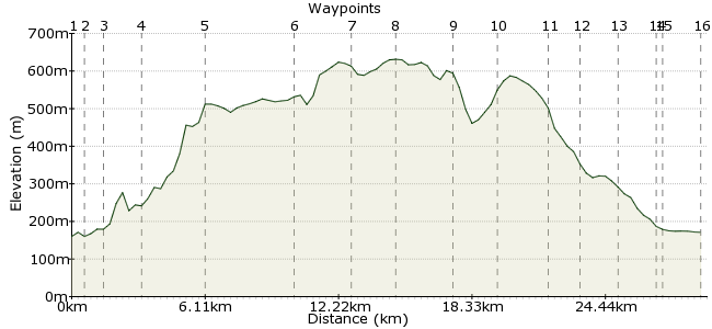
Ascent
473m (1551ft)
Descent
462m (1515ft)
Max. Elevation
640m (2099ft)
Altitude Gain & Loss
935m (3066ft)
Start
Glossop Station
End
Hope
Distance
29.10km
(18.08mi)
(18.08mi)
Duration
~9:45h
Difficulty
Strenuous
Ordnance Survey Map
A strenuous walk from Glossop to Hope, mostly on good paths. The length of the walk is what makes it challenging.
Walk Functions
Share
Nearby Walks
Higher and Lower Shelf Stones and crash sites
A moderate, circular walk (mountain (above 600m)) starting in Derbyshire, England, about 12.80km (7.95 mi) long, duration: ~5:00h.The Grouse to Edale
A moderate, linear walk (low hills and fells (below 600m)) starting in Derbyshire, England, about 12.90km (8.02 mi) long, duration: ~4:30h.Lantern Pike from Hayfield
A leisurely, circular walk (low hills and fells (below 600m)) starting in Derbyshire, England, about 7.50km (4.66 mi) long, duration: ~2:45h.Walk Map
- $walk->POI array(0)
Waypoints
OS Grid SK034942
Trains from Manchester.
Exit station and turn right down Norfolk St, then left onto Howard St East. Continue along the road and across until you reach Manor Park Rd.
OS Grid SK041942
Turn left into Manor Park Rd and continue straight on until you reach the Queens Arms. Turn right into Shepley Street and continue along it past the factories, until you reach the turning circle and public footpath.
About 0.69 km (~0.43 miles) from 
OS Grid SK045948
Follow the track along, with the Shelf Brook to your right.You will reach a gate, at which point you need to continue straight on, ignoring the tempting looking path up the hill! Eventually, you will come across a sign for Doctor's Gate, which you will follow for the next couple of miles.
About 0.77 km (~0.48 miles) from 
OS Grid SK064944
(approximate location- sign is pretty obvious, though) Continue along Doctor's Gate, crossing Shelf Brook at the footbridge, until you reach the Pennine Way crossing. Doctor's Gate is an old Roman Road connecting the forts of Melandra near Glossop and Navio, near Brough, although this section of the "road" is thought to pre-date the Roman occupation.
About 1.87 km (~1.16 miles) from 
OS Grid SK089933
Turn right along the broad track of the Pennine Way. It's tarmaced at this point. If you're there in June/July, it's worth looking out for orchids here, especially by a small pool near the Snake Road.
Cross the Snake Road and continue along the Pennine Way (well paved here) across Featherbed Moss to Mill Hill.
About 2.78 km (~1.73 miles) from 
OS Grid SK060904
Descend from Mill Hill to a crossing of paths. Continue straight ahead on a steep ascent. Head roughly south east towards Sandy Heys and continue on the well defined path to Kinder Downfall.
About 4.09 km (~2.54 miles) from 
OS Grid SK082889
Cross the river Kinder at the top of the Downfall. The crossing is easy. Continue along the Pennine Way until you reach the trig point at Kinder Low.
About 2.64 km (~1.64 miles) from 
OS Grid SK078870
Head east from Kinder Low to join a path at Edale Head. The going may get a bit tough, as you cross the peat bog, but it's not for long. Keep following this path, crossing Crowden Brook and Grindsbrook.
About 1.89 km (~1.17 miles) from 
OS Grid SK105872
If the lure of a pint and a hot dinner is too much, you can scramble down Grindsbrook or head over Grindslow Knoll and be down in Edale in approximately 1 hour.
Otherwise, cross the main Grindsbrook and follow one of the tributaries in from the edge a short way to make a crossing. Follow the path past Upper Tor to Nether Tor.
About 2.69 km (~1.67 miles) from 
OS Grid SK124875
If you wish to go down to Edale at this point, you can follow Golden Clough. to continue this walk, take the path to the rocky escarpment of Ringing Roger. From there, continue roughly east on a path along the edge of the plateau, until you reach Crookstone Hill.
About 1.96 km (~1.22 miles) from 
OS Grid SK146882
From Crookston Hill, follow the path roughly south east, through fields until you reac a junction of paths, jnot far from Crookstone Barn. Crookstone Barn is a residential centre for school/youth groups and is screened by trees.
About 2.30 km (~1.43 miles) from 
OS Grid SK159876
Continie south east. You will pass Hope Cross, an old fashioned guide stoop, used for watmarking. You'll find yourself on a sandy path, which is a continutation of the roman road you walked on earlier in the day.Continue, with the plantation to your left, until the next waypoint.
About 1.42 km (~0.88 miles) from 
OS Grid SK169862
Here, you start your descent on a clear path down the hillside. Eventaully, you come out to a gate onto a lane. Follow the lane to Fulwood Style Farm and follow the directions through the farmyard (painted on walls).
About 1.71 km (~1.06 miles) from 
OS Grid SK170848
Cross the fields to a couple of houses on the other side. Go down the side of one of the houses and follow the lane along. Turn right at the road and over the bridge.
About 1.41 km (~0.88 miles) from 
OS Grid SK167844
You have 2 choices here. Either turn left and head along the main road into Hope and on to the station. There are a few pubs in Hope if you want to stop there. The other choice is to go right along the road for a few minutes until you reach the Cheshire Cheese, which serves amazing food.
About 0.44 km (~0.27 miles) from 
 Hope station
OS Grid SK180832
Trains to Manchester & Sheffield.
About 1.72 km (~1.07 miles) from 
