Place Fell from Patterdale
A moderate walk (mountain (above 600m)) in national park Lake District in Cumbria, England, about 9.80km (6.09 mi) long with an estimated walking time of about 4:15h. It is suitable for families with children, but unsuitable for prams & pushchairs, wheelchairs.
Elevation Profile
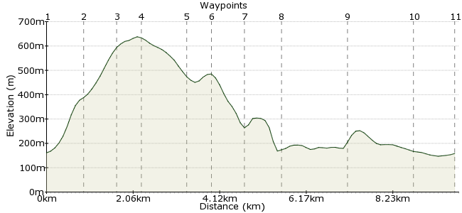
Ascent
499m (1637ft)
Descent
502m (1646ft)
Max. Elevation
640m (2099ft)
Altitude Gain & Loss
1001m (3283ft)
Start & End
Patterdale
Distance
9.80km
(6.09mi)
(6.09mi)
Duration
~4:15h
Difficulty
Moderate
Ordnance Survey Map
The smaller fells in the Lake District sometimes get overlooked in the dash to the highest peaks. This walk may look modest, but has all the ingredients: a scrambly ascent up Place Fell, a lakeside walk along Ullswater and a good pub in Patterdale at the end. Patterdale has good bus connections from Penrith.
Walk Functions
Share
Nearby Walks
High Street from Patterdale
A moderate, circular walk (mountain (above 600m)) starting in Cumbria, England, about 15.50km (9.63 mi) long, duration: ~6:30h.YHA Patterdale to YHA Grasmere
A moderate, linear walk (mountain (above 600m)) starting in Cumbria, England, about 12.20km (7.58 mi) long, duration: ~5:30h.Grisedale low-level walk
A leisurely, circular walk (low hills and fells (below 600m)) starting in Cumbria, England, about 7.20km (4.47 mi) long, duration: ~2:15h.Walk Map
- $walk->POI array(0)
Waypoints
OS Grid NY399159
Take the bus to Patterdale. Cross Goldrill Beck and turn right along the road.
OS Grid NY408157
From Rooking, the village on the opposite side of the beck, take the path to Boredale Hause.
About 0.85 km (~0.53 miles) from 
OS Grid NY407165
A steep climb leads up the southern slopes of Place Fell, over Round How.
About 0.74 km (~0.46 miles) from 
OS Grid NY405170
A modest height by Lake District standards – just 651m – but unrivalled views over Ullswater.
About 0.56 km (~0.35 miles) from 
OS Grid NY412178
The descent weaves between Black Crag and Mortar Crag.
About 1.05 km (~0.65 miles) from 
OS Grid NY415182
It would be rude to walk this close to High Dodd and not go to the top.
About 0.54 km (~0.34 miles) from 
OS Grid NY414189
Drop down the the beck running northwards from the fell.
About 0.71 km (~0.44 miles) from 
OS Grid NY407193
Skirt past the woodland to pick up the bridleway running alongside Ullswater.
About 0.79 km (~0.49 miles) from 
OS Grid NY397182
Walking alongside Ullswater is a treat; take your time, perhaps with a wee sit down at Silver Point.
About 1.52 km (~0.94 miles) from 
OS Grid NY396167
Continue past the campsite back towards Rooking.
About 1.57 km (~0.98 miles) from 
 Patterdale
OS Grid NY397157
Back into Patterdale for the bus home, and perhaps a pint in the White Lion beforehand.
About 0.96 km (~0.6 miles) from 
