Helmsley to Wass
A moderate walk (low hills and fells (below 600m)) in national park North York Moors starting and finishing in North Yorkshire, England, about 13.50km (8.39 mi) long with an estimated walking time of about 4:30h. It is suitable for families with children, but unsuitable for prams & pushchairs, wheelchairs.
Elevation Profile
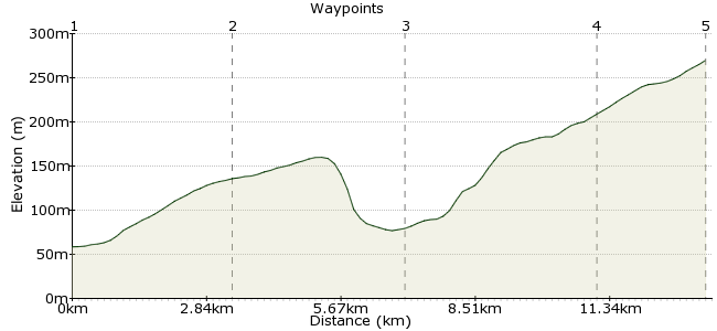
Ascent
212m (695ft)
Descent
168m (551ft)
Max. Elevation
270m (885ft)
Altitude Gain & Loss
380m (1246ft)
Start
Helmsley or Wass
End
Wass
Distance
13.50km
(8.39mi)
(8.39mi)
Duration
~4:30h
Difficulty
Moderate
Ordnance Survey Map
This walk explores fields and woods and has one climb over open pasture which gives excellent views of the hills of the moors in the distance, especially between Rievaulx and the A170. The paths are all fairly easy to find and the walk should take around 3-4 hours. If you are struggling to find public transport to/from Wass (its bus service is due to be cut to a large extent), look for services between Ampleforth and Malton.
Walk Functions
Share
Nearby Walks
Danby
A leisurely, circular walk (countryside) starting in North Yorkshire, England, about 8.50km (5.28 mi) long, duration: ~2:45h.Roseberry Topping
A leisurely, circular walk (low hills and fells (below 600m)) starting in North Yorkshire, England, about 6.90km (4.29 mi) long, duration: ~2:30h.Goathland to Grosmont
A leisurely, linear walk (countryside) starting in North Yorkshire, England, about 6.20km (3.85 mi) long, duration: ~1:45h.Walk Map
- $walk->POI array(0)
Waypoints
OS Grid SE612837
From the bus stops cross the market place and head towards the castle. Turn right and follow the path past the Tourist Information to a car park. Continue through the car park and turn left down the Cleveland Way.
OS Grid SE578840
After about 3km you will reach a road. Turn left along the footpath to the side of this road and follow this for about 500m until you reach a bridge. If you wish to visit Rievaulx Abbey turn right here. Otherwise continue across the narrow bridge.
About 3.45 km (~2.14 miles) from 
OS Grid SE545853
After crossing a second bridge, turn left up a gradual slope through woods which opens out onto open pasture. Continue across this pasture and you will see great views of the North York Moors behind you. Continue past a farm and cross the A170 with care.
About 3.55 km (~2.21 miles) from 
OS Grid SE558815
From here, descend through woods to the little village of Wass. Continue through woods until you reach a minor road - here, turn right. If you wish to discover a hidden valley, turn left off the road to Long Grain and Low Wood. At the end of the valley turn right and walk through fields to Wass.
About 4.01 km (~2.49 miles) from 
 Finish in Wass
OS Grid SE555793
Finish up in Wass for the bus home. If you wish to see Byland Abbey continue along the road from Wass.
About 2.24 km (~1.39 miles) from 
