Brynsiencyn
A moderate walk (countryside) in Isle of Anglesey, Wales, about 10.90km (6.77 mi) long with an estimated walking time of about 3:15h. It is unsuitable for families with children, prams & pushchairs, wheelchairs.
Elevation Profile
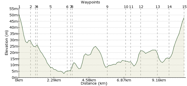
Ascent
51m (167ft)
Descent
53m (173ft)
Max. Elevation
60m (196ft)
Altitude Gain & Loss
104m (340ft)
Start & End
Brynsiencyn
Distance
10.90km
(6.77mi)
(6.77mi)
Duration
~3:15h
Difficulty
Moderate
Ordnance Survey Maps
 1Created by driver 16 on 18 Dec 2013
The weathermen and women got it right: a crisp, dry and sunny December day for this walk on field paths, tracks, lanes and tarmac roads. The route passes Bridea Stud, Halen Mon sea salt factory and shop (featured on TV a number of times), the Sea Zoo, Foel Farm Park and Bistro restaurant, and the remains of the pier used for ferries to Caernarfon. The views over the Menai Straight of mountains of Snowdonia are exceptional; the new holiday cottages, riding school, and Neolithic and Bronze Age ruins add further interest to this route.
Walk Functions
Share
Nearby Walks
Caernarfon, castle and town walls
A leisurely, circular walk (countryside) starting in Gwynedd, Wales, about 8.00km (4.97 mi) long, duration: ~2:15h.Roman Caernarfon
A leisurely, circular walk (city/town) starting in Gwynedd, Wales, about 1.50km (0.93 mi) long, duration: ~0:30h.Menai Bridge to Beaumaris
A leisurely, linear walk (countryside) starting in Isle of Anglesey, Wales, about 10.10km (6.28 mi) long, duration: ~3:00h.Walk Map
- $walk->POI array(0)
Waypoints
OS Grid SH484670
Read the history boards in the car park, then look for the sign for a circular walk. Turn right and follow the road to waypoint 2.
OS Grid SH491668
Opposite the entrance to Bridea Stud, climb the stile or enter through a gate. Bear slightly right across the field to the far-right corner, past a marker post for the Anglesey coastal path. Here you will see a new kissing gate on the left of an old stone stile.
About 0.79 km (~0.49 miles) from 
OS Grid SH489666
Bear left, then right on a clearly defined path through trees and undergrowth covering disused quarry. At the large clearing, go straight on to the stile.
About 0.29 km (~0.18 miles) from 
OS Grid SH489666
Climb over and keep to the hedge on the left of three fields.
About 0.07 km (~0.04 miles) from 
OS Grid SH483659
Cross the track by passing through two new kissing gates. Cross the middle of the field, aiming to the left of the trees, to find a stone stile onto the beach.
About 0.87 km (~0.54 miles) from 
OS Grid SH477650
Turn right and follow the beach, looking out for rewarding views of Snowdonia. There are also various species of birds, especially waders in winter. Climb a few concrete steps onto the road.
About 1.10 km (~0.68 miles) from 
OS Grid SH476649
Pass Halen Mon sea salt factory and shop, then the Sea Zoo. Pass the entrance to Foel Farm Park, shop and Bistro restaurant and continue to what was the Mermaid Inn, and now is a private residence, Dock House. From here you can pick out the foundations of the ruined pier; before bridges were built over the Strait, the Tal-y-foel ferry carried passengers to Caernarfon. Retrace your way back to the road.
About 0.16 km (~0.1 miles) from 
OS Grid SH476649
Stay on this road, passing a new holiday cottages development, then uphill to meet the A4080.
About 0.04 km (~0.02 miles) from 
OS Grid SH456660
If interested, you will find the riding school if you turn left: it's on the left about 3/4 of a mile. For this walk, turn right and pass Bryn Gwyn Hall. You will see a sign for Castell Bryn Gwyn on the left.
About 2.25 km (~1.4 miles) from 
OS Grid SH466667
The track twists and turns until a kissing gate entrance to a field. Ahead is not a castle, just mounds of grass-covered earth in a circle. Head across the middle of the field and down the bank to a stile into the next field.
About 1.19 km (~0.74 miles) from 
OS Grid SH462669
Climb over the stile and slant left towards a house. Cross a corner stile, go ahead, then right through a gate and over two more stiles. Here you will see two prominent standing stones. Follow the wall on your right to cross the next stile. Cross a small bridge, through the gate, through the middle of two ponds, then through another gate up to a lane.
About 0.40 km (~0.25 miles) from 
OS Grid SH458673
Turn right, follow to a Y-junction.
About 0.56 km (~0.35 miles) from 
OS Grid SH467680
Look on your left for a small sign in the ground for outbuildings. Turn left; after about 1/2 a mile, on the right is the kissing-gate entrance to a burial chamber. Head back to the Y-junction, the turn right and downhill to cross a little bridge over the Afon Braint. Ignore the footpath sign on your right; just after you will find a kissing gate on the right and a sign for Caer Leb.
About 1.09 km (~0.68 miles) from 
OS Grid SH473675
After visiting, exit to the right to follow the road back into the village.
About 0.78 km (~0.48 miles) from 
 End of the walk
OS Grid SH482671
A handy reference book, which goes into greater detail of the history of the points of interest on this walk, is Dorothy Hamilton's 'Circular Walks on Anglesey', ISBN 0-86381-478-6. The history is there, but, directions are a bit dated, so be careful – I went off track on a couple of the walks. Hope you enjoy it.
About 0.94 km (~0.58 miles) from 
