Dorking to Reigate via Box Hill
A moderate walk (low hills and fells (below 600m)) starting and finishing in Surrey, England, about 12.20km (7.58 mi) long with an estimated walking time of about 4:00h. It is suitable for families with children, but unsuitable for prams & pushchairs, wheelchairs.
Elevation Profile
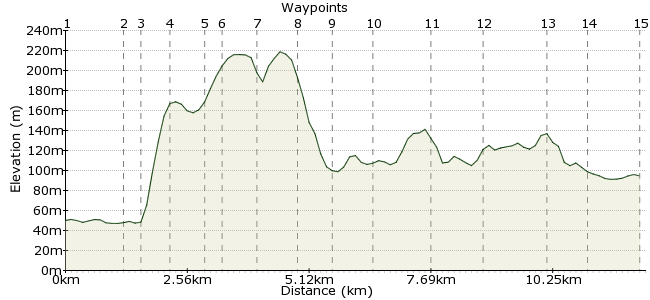
Ascent
239m (784ft)
Descent
195m (639ft)
Max. Elevation
220m (721ft)
Altitude Gain & Loss
434m (1423ft)
Start
Dorking Deepdene
End
Reigate
Distance
12.20km
(7.58mi)
(7.58mi)
Duration
~4:00h
Difficulty
Moderate
Ordnance Survey Map
The trainline running to the south of the North Downs is perfect for linear walks along this welcoming stretch of hills. It's quick to get from platform to hill, so you can spend much of the day on the tops, where there are many rewarding views. This route takes in the stretch between Dorking and Reigate.
Walk Functions
Share
Nearby Walks
Dorking to Gomshall - walk the chalk
A moderate, linear walk (woodland) starting in Surrey, England, about 9.70km (6.03 mi) long, duration: ~3:15h.Up Box Hill the easy way
A moderate, circular walk (countryside) starting in Surrey, England, about 10.80km (6.71 mi) long, duration: ~3:45h.North Downs Way: Boxhill to Reigate
A moderate, linear walk (low hills and fells (below 600m)) starting in Surrey, England, about 11.70km (7.27 mi) long, duration: ~4:00h.Walk Map
- $walk->POI array(0)
Waypoints
OS Grid TQ170501
Take the train to Dorking Deepdene, which is on the same line as Reigate, at the end of the walk. There are other options, such as the bus and the main Dorking station.
Go down the steps from the platform and turn right under the railway bridge.
OS Grid TQ170513
Bit of a road section to start with. Sorry about that. It should only take 20 mins or so to reach the footpath turning right from the road towards Box Hill.
About 1.21 km (~0.75 miles) from 
OS Grid TQ173511
Cross the bridge and keep going straight until you reach a set of steep steps. Go up them.
About 0.38 km (~0.24 miles) from 
OS Grid TQ179511
The steps take you through the woods to a viewpoint with some cracking views. You can see the South Downs on clear days and also much of the North Downs. The stone viewpoint has markers pointing out the different points on the horizon.
About 0.59 km (~0.37 miles) from 
OS Grid TQ186511
Head east along the main path, which is a short distance from the road through Box Hill Country Park. Expect the road to be full of cyclists - it's all the rage since the Olympic cycling passed through here. You should spot at least one cyclist with sideburns in tribute to Bradley Wiggins.
About 0.65 km (~0.4 miles) from 
OS Grid TQ188511
Not far from the viewpoint is an American Diner. Perhaps not exactly what you'd expect to find in the Surrey Hills, but the onion rings come highly recommended.
About 0.26 km (~0.16 miles) from 
OS Grid TQ196513
The path weaves up and down the south-facing slope of the Downs, with some bits a little slippery.
About 0.73 km (~0.45 miles) from 
OS Grid TQ202515
The path opens out a little at an old quarry, with views across Surrey again. You can duck out to Betchworth station here, but note that trains only go every two hours.
About 0.74 km (~0.46 miles) from 
OS Grid TQ210516
When you pass the houses and reach the road, turn left uphill. The main path is soon on your right.
About 0.75 km (~0.47 miles) from 
OS Grid TQ214522
Pick up the North Downs Way for the final section of the walk.
About 0.71 km (~0.44 miles) from 
OS Grid TQ226525
This section is a little more open, with views most of the way to the south.
About 1.21 km (~0.75 miles) from 
OS Grid TQ235519
There is a path along the top of the ridge, but I prefer to drop down at Juniper Hill and traverse lower down.
About 1.05 km (~0.65 miles) from 
OS Grid TQ247518
Where the path crosses the Greensand Way, take the steep path dropping down into Reigate.
About 1.29 km (~0.8 miles) from 
OS Grid TQ244510
Follow the road through the smart houses of Colley Way into Reigate.
About 0.84 km (~0.52 miles) from 
 Station
OS Grid TQ254507
Turn left into Manor Road towards the station. There are pubs just beyond the station in town if you need a snifter.
About 1.07 km (~0.66 miles) from 

1 comment... join the discussion!
Donna
The walk was very nice. Really quiet once you get past Box Hill. We've lived in the area for about two years, but we saw lots things we didn't know were there, esp around the quarry. We did go wrong a few times: We turned off the A24 at the National Trust car park for the Stepping Stones, as we knew that was Box Hill. We should have kept going to the path actually signed to Box Hill. The directions don't really mention the North Downs Way until near the end. In fact, we stayed on the North Downs Way from Box Hill Village (near the American diner mentioned in the directions) to nearly the end. Not sure if that was the intent, but it worked well for us. We went wrong at the end as well, but that was okay, as we met some cheerful people who sent us on to Reigate. There, we had great sandwiches and beverages at The Roe Deer, just down the road from the station (theroedeer.co.uk). I would say that a walking pole is a good idea if you would normally use one for steeper walks. It will also help for balance, as some of the chalk paths could get very slippery when wet.