Moel Siabod - the best views in Snowdonia
A leisurely walk (mountain (above 600m)) in national park Snowdonia in Clwyd, Wales, about 8.20km (5.10 mi) long with an estimated walking time of about 4:15h. It is unsuitable for families with children, prams & pushchairs, wheelchairs.
Elevation Profile
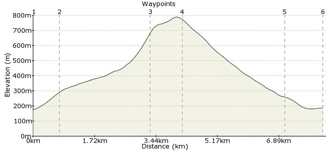
Ascent
673m (2208ft)
Descent
662m (2171ft)
Max. Elevation
790m (2591ft)
Altitude Gain & Loss
1335m (4379ft)
Start & End
Capel Curig Bus Stop
Distance
8.20km
(5.1mi)
(5.1mi)
Duration
~4:15h
Difficulty
Leisurely
Ordnance Survey Maps
Moel Siabod is a great mountain walk - the views from the summit to the west rank among the best in North Wales. From here, you get the perfect view of three great ranges in North Walks - Snowdon, the Glyders and the Carneddau. It's a good day out in itself, passing old mine ruins, a remote lake and with the option of a simple scramble to the summit. Even better, the walk starts and finishes near some cosy pubs in Capel Curig, easily reached using the Snowdon Sherpa buses.
Walk Functions
Share
Nearby Walks
Llyn Crafnant - a valley walk in Snowdonia
A moderate, linear walk (low hills and fells (below 600m)) starting in Clwyd, Wales, about 11.70km (7.27 mi) long, duration: ~3:45h.Capel Curig
A leisurely, circular walk (countryside) starting in Gwynedd, Wales, about 5.70km (3.54 mi) long, duration: ~1:45h.Dolwyddelan Castle
A moderate, circular walk (countryside) starting in Clwyd, Wales, about 10.10km (6.28 mi) long, duration: ~3:30h.Walk Map
- $walk->POI array(0)
Waypoints
OS Grid SH732571
From the bus stop in Pont Cyfyng (just before Capel Curig), cross the river and follow the road. After about 150m, take the footpath heading up through the woods.
OS Grid SH728565
Follow the private road going uphill past Rhos Farm and some disused houses. The path soon joins the open hillside, with Moel Siabod visible straight ahead.
About 0.76 km (~0.47 miles) from 
OS Grid SH713546
Follow the obvious path towards the mountain until you will reach an old quarry. A good stop for a cup of tea and a biscuit. Continue to the far ridge, where a simple scramble takes you to the summit. In high winds, follow the gully before the main ridge.
About 2.44 km (~1.52 miles) from 
OS Grid SH704546
From the quarry, head around Llyn y Foel. To get to the summit, there are two options: there is an easy scramble up the Daear Ddu ridge, or the steep climb up the river valley before this ridge. Both are good fun, but the valley climb is more sheltered - leave the scramble for nice weather.
About 0.85 km (~0.53 miles) from 
OS Grid SH716572
Head along the summit ridge in a northeasterly direction. This is a long, gently sloping walk across moorland. There is a rough path, but head for the western edge of the forest ahead. Follow the path into the woods and you will join a larger path.
About 2.87 km (~1.78 miles) from 
 Bryn Tyrch Hotel
OS Grid SH725577
Follow the path through the woods back to the A5 and Capel Curig. Head for the Bryn Tyrch pub for a well earned drink. This is a very cosy pub, walker friendly, and they also do great food. Enjoy!
About 1.03 km (~0.64 miles) from 
