Glencoe to the Clachaig Inn
A moderate walk (riverside) in Highlands, Scotland, about 10.10km (6.28 mi) long with an estimated walking time of about 3:00h. It is unsuitable for families with children, prams & pushchairs, wheelchairs.
Elevation Profile
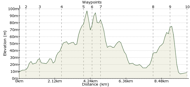
Ascent
111m (364ft)
Descent
112m (367ft)
Max. Elevation
100m (328ft)
Altitude Gain & Loss
223m (731ft)
Start & End
Glencoe
Distance
10.10km
(6.28mi)
(6.28mi)
Duration
~3:00h
Difficulty
Moderate
Ordnance Survey Map
This is one of the tamer walks in Glencoe. But who says you have to climb mountains to enjoy them? Sticking to the valley, this short walk finishes at the famous Clachaig Inn, where you can sit and admire the towering peaks with a pint in hand, or maybe a whisky, given the territory.
Walk Functions
Share
Nearby Walks
Sgor na h-Ulaidh in Glencoe
A moderate, circular walk (mountain (above 600m)) starting in Highland, Scotland, about 17.20km (10.69 mi) long, duration: ~7:45h.The eastern Mamores
A moderate, circular walk (mountain (above 600m)) starting in Highlands, Scotland, about 13.40km (8.33 mi) long, duration: ~7:00h.A low-level walk along the lochs
A moderate, linear walk (low hills and fells (below 600m)) starting in Highlands, Scotland, about 21.00km (13.05 mi) long, duration: ~7:30h.Walk Map
- $walk->POI array(0)
Waypoints
OS Grid NN099588
Take the bus to Glencoe village.
OS Grid NN103589
Head along Lorn Drive past the post office, then across the river.
About 0.43 km (~0.27 miles) from 
OS Grid NN110586
The route follows a very quiet road into Glencoe. The Pap of Glencoe is to your left and makes for a very steep side trip should you fancy it.
About 0.71 km (~0.44 miles) from 
OS Grid NN117576
Follow the course of the River Coe past the youth hostel.
About 1.24 km (~0.77 miles) from 
OS Grid NN127568
As you continue, the massive end of Sgorr nam Flannaidh looms up above. This is the start (or end) of the Aonach Eagach ridge, a name that strikes fear and excitement into all walkers.
About 1.24 km (~0.77 miles) from 
OS Grid NN123566
Before heading to the pub, climb up Signal Rock for one of the classic views of the Glencoe valley.
About 0.43 km (~0.27 miles) from 
OS Grid NN127566
Time your walk to arrive here for lunch, they have an excellent menu:
www.clachaig.com
About 0.40 km (~0.25 miles) from 
OS Grid NN106588
Retrace your steps from here towards Glencoe. Sometimes walkers resent this idea, but when the scenery's this good, who's complaining?
About 3.04 km (~1.89 miles) from 
OS Grid NN102597
Where the road turns left into the village, take the track to the Glencoe Lochan. There is a path right around the lochan, with great views of the Pap.
About 0.94 km (~0.58 miles) from 
 Glencoe again
OS Grid NN098587
Finish up in the village for the bus home or for further adventures in Western Scotland.
About 1.05 km (~0.65 miles) from 
