Colwyn Heights
A leisurely walk (countryside) in Clwyd, Wales, about 5.80km (3.60 mi) long with an estimated walking time of about 2:00h. It is suitable for families with children, but unsuitable for prams & pushchairs, wheelchairs.
Elevation Profile
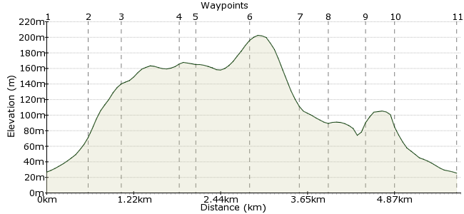
Ascent
208m (682ft)
Descent
209m (685ft)
Max. Elevation
210m (688ft)
Altitude Gain & Loss
417m (1367ft)
Start & End
Colwyn Bay
Distance
5.80km
(3.6mi)
(3.6mi)
Duration
~2:00h
Difficulty
Leisurely
Ordnance Survey Map
 1Created by driver 16 on 04 Jul 2014
A gem of a walk through woods and open fields on well maintained paths, bridleways, tracks and short stretches of tarmac with spectacular views in all directions over Anglesey, the Conway Valley, the Carneddau, Snowdonia and the Clwydian Range, born and bred in area, right on my doorstep, but, only just discovered thanks to Lesley the Cerdded Conwy guide.
Walk Functions
Share
Nearby Walks
Xmas Day circular from Colwyn Bay
A moderate, circular walk (countryside) starting in Clwyd, Wales, about 15.20km (9.44 mi) long, duration: ~4:30h.Circular E, S. and W. from C/Bay.
A moderate, circular walk (coast) starting in Clwyd, Wales, about 14.00km (8.70 mi) long, duration: ~4:15h.Colwyn Bay, Llanddulas, Llysfaen circular
A moderate, circular walk (countryside) starting in Clwyd, Wales, about 14.00km (8.70 mi) long, duration: ~4:30h.Walk Map
- $walk->POI array(0)
Waypoints
OS Grid SH845791
Only 100 yards from either bus stop from E. or W., continue to mini roundabout, turn left into Pwllycrochan Ave., pass both Rydal and Penrhos private schools to top of hill and edge of woods, waypoint 2.
OS Grid SH842786
Cross and enter woods to see information board, turn right on woodland path to waypoint 3.
About 0.60 km (~0.37 miles) from 
OS Grid SH839784
Exit woods to left, cross Llanrwst Road, in about 50 yards find signed narrow path between houses, follow to join Copthorne Road, waypoint 4.
About 0.44 km (~0.27 miles) from 
OS Grid SH833779
Follow Copthorne Road btween houses into Pen-y-Mynydd and onto The View, after taking in the spectacular views, retrace steps to Hafoty Lane, waypoint 5.
About 0.73 km (~0.45 miles) from 
OS Grid SH835779
Follow to Llanrwst Road, turn right and left into Honeysuckle Lane.
About 0.17 km (~0.11 miles) from 
OS Grid SH841775
Follow footpath to waypoint 7.
About 0.71 km (~0.44 miles) from 
OS Grid SH847776
Worth a small detour to top of Bryn Cadno for more spectacular views, retrace steps back to entrance to continue to waypoint 8.
About 0.61 km (~0.38 miles) from 
OS Grid SH850778
Join, turn left and follow to waypoint 9.
About 0.32 km (~0.2 miles) from 
OS Grid SH852781
Enter, follow through woods to join Pen-y-Bryn road waypoint 10.
About 0.42 km (~0.26 miles) from 
OS Grid SH849783
Enter and follow path above Old Highway back to waypoint 2, exit woods, downhill back to mini roundabout and waypoint 1, hope you enjoyed.
About 0.40 km (~0.25 miles) from 
 End of walk
OS Grid SH846791
Hope you enjoyed and will recommend to friends.
About 0.85 km (~0.53 miles) from 
