Burrator Reservoir from Yelverton
A moderate walk (low hills and fells (below 600m)) in national park Dartmoor in Devon, England, about 18.70km (11.62 mi) long with an estimated walking time of about 6:30h. It is unsuitable for families with children, prams & pushchairs, wheelchairs.
Elevation Profile
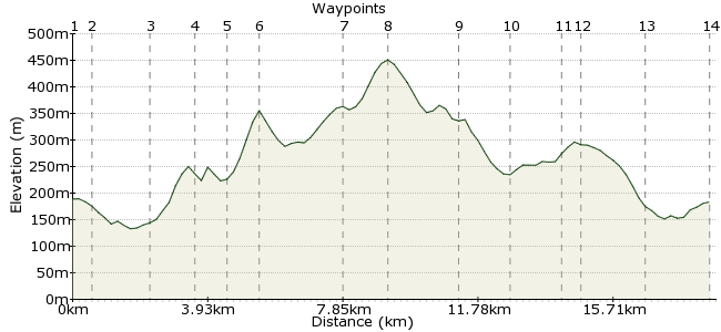
Ascent
377m (1236ft)
Descent
383m (1256ft)
Max. Elevation
460m (1509ft)
Altitude Gain & Loss
760m (2492ft)
Start & End
Yelverton
Distance
18.70km
(11.62mi)
(11.62mi)
Duration
~6:30h
Difficulty
Moderate
Ordnance Survey Map
This is a splendid walk in southwest Dartmoor. There's a bit of a trudge along the road to start and finish, but they are country lanes rather than open highways. Take care though; the high hedges in Devon mean cars won't always see you. The bulk of the walk is on the open moor, however, touring around Burrator Reservoir. Yelverton has good bus connections.
Walk Functions
Share
Nearby Walks
Calstock to Cotehole
A leisurely, circular walk (riverside) starting in Cornwall, England, about 4.30km (2.67 mi) long, duration: ~1:15h.The Devonport Leat - a short walk from Princetown
A moderate, circular walk (moorland) starting in Devon, England, about 11.00km (6.84 mi) long, duration: ~3:30h.Princetown to Bellever
A moderate, linear walk (moorland) starting in Devon, England, about 10.90km (6.77 mi) long, duration: ~3:30h.Walk Map
- $walk->POI array(0)
Waypoints
OS Grid SX519678
Take the bus to Yelverton, a stop on the regular Plymouth-Tavistock route.
OS Grid SX524674
Head southeast out of town to Meavy Lane. Bit of a road walk to start with. Sorry about that.
About 0.60 km (~0.37 miles) from 
OS Grid SX541672
Follow the road uphill to Meavy. Continue past the church to a T-junction and directly opposite is a footpath.
About 1.69 km (~1.05 miles) from 
OS Grid SX550680
The path weaves through the woodland to the edge of the reservoir.
About 1.22 km (~0.76 miles) from 
OS Grid SX558677
Follow the road around the reservoir and then through Sheepstor.
About 0.81 km (~0.5 miles) from 
OS Grid SX566682
First good view of the day from Sheeps Tor over the reservoir.
About 0.94 km (~0.58 miles) from 
OS Grid SX589678
Veer southeast from the summit towards Ditsworthy Warren. There is a track crossing this region, and follow this to the cairn to the northwest.
About 2.32 km (~1.44 miles) from 
OS Grid SX599686
At the cairn, leave the path and head north along the high ground to circle around the reservoir.
About 1.35 km (~0.84 miles) from 
OS Grid SX580693
Head downhill across the moor to Downs Tor, towards the reservoir once more.
About 2.06 km (~1.28 miles) from 
OS Grid SX567693
Pick up the road once more. Just beyond the bend is a footpath on the right-hand side which avoids trudging along the road.
About 1.34 km (~0.83 miles) from 
OS Grid SX552692
The path heads through the forest and then onto a road.
About 1.47 km (~0.91 miles) from 
OS Grid SX546691
At the car park pick up the path heading south, back towards Meavy.
About 0.55 km (~0.34 miles) from 
OS Grid SX540674
Return to Meavy. There's a pub here if you need refreshing: www.royaloakinn.org.uk
About 1.83 km (~1.14 miles) from 
 Yelverton once more
OS Grid SX522676
Retrace your steps along the road back to Yelverton. There are pubs here too.
About 1.81 km (~1.12 miles) from 
