Loughrigg Fell and Lingmoor Fell
A moderate walk (low hills and fells (below 600m)) in national park Lake District starting and finishing in Cumbria, England, about 13.90km (8.64 mi) long with an estimated walking time of about 5:30h. It is unsuitable for families with children, prams & pushchairs, wheelchairs.
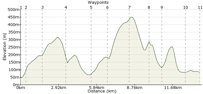
Elevation Profile
Ascent
525m (1722ft)
Descent
490m (1607ft)
Max. Elevation
460m (1509ft)
Altitude Gain & Loss
1015m (3329ft)
Start
Ambleside
End
Chapel Stile
Distance
13.90km
(8.64mi)
(8.64mi)
Duration
~5:30h
Difficulty
Moderate
Two of the Lake District's lesser lights star in this walk from Ambleside. The low heights (a maximum of 466m) make this a good option for days when there are clouds on the tops. You can finish in Elterwater and get the bus back or do a circular route from Ambleside. Make time to pop into the Britannia Inn in Elterwater too: http://thebritanniainn.com
Walk Functions
Share
Nearby Walks
Rydal Water and Grasmere
A moderate, linear walk (low hills and fells (below 600m)) starting in Cumbria, England, about 10.80km (6.71 mi) long, duration: ~4:15h.Fairfield Horseshoe from Ambleside
A moderate, circular walk (mountain (above 600m)) starting in Cumbria, England, about 16.40km (10.19 mi) long, duration: ~7:00h.Wansfell - the scenic route from Ambleside to Windermere
A leisurely, linear walk (low hills and fells (below 600m)) starting in Cumbria, England, about 8.90km (5.53 mi) long, duration: ~3:45h.Walk Map
- $walk->POI array(0)
Waypoints
OS Grid NY371045
Take the bus to Ambleside, one the Lake District's many charming towns. Head out through the town along Rydal Road and, once around the corner (the one with the outdoors shop), look for the footpath on the left.
OS Grid NY366045
Cross the river and the road, turning right on the other side. After a short distance, a footpath heads uphill via Brow Head Farm.
About 0.50 km (~0.31 miles) from 
OS Grid NY355043
Continue onto Loughrigg Fell. At the crag, follow the track towards the summit.
About 1.19 km (~0.74 miles) from 
OS Grid NY342057
At the top, make sure you pause for the view over Rydal Water - one of the region's classic views. Drop down towards Loughrigg Terrace.
About 1.81 km (~1.12 miles) from 
OS Grid NY327046
From the terrace, join the road into Elterwater. Head straight through the village and continue on the road heading south.
About 1.82 km (~1.13 miles) from 
OS Grid NY317038
After about 1km, you reach a path which leads up onto Lingmoor Fell.
About 1.29 km (~0.8 miles) from 
OS Grid NY303045
What it lacks in height it more than compensates for in views. Great views towards the Langdales. A good lunch spot.
About 1.56 km (~0.97 miles) from 
OS Grid NY289053
Continue heading along Lingmoor Fell to the secondary summit of Side Pike. Take the zigzag path dropping down the southwestern flank.
About 1.58 km (~0.98 miles) from 
OS Grid NY295059
Take the path leading around the base of Lingmoor Fell into Great Langdale.
About 0.82 km (~0.51 miles) from 
OS Grid NY312056
The route takes the low-level path along the floor of Great Langdale back to Elterwater.
About 1.72 km (~1.07 miles) from 
 Elterwater
OS Grid NY322052
Finish up in Elterwater. Buses run back to Ambleside from here, every two hours or so. Or you can retrace your steps back over Loughrigg Fell, or continue along the valley via Skelwith Bridge.
About 1.11 km (~0.69 miles) from 
