Kings Head 11 mile loop from Ludford
A moderate walk (countryside) in Lincolnshire, England, about 14.40km (8.95 mi) long with an estimated walking time of about 4:30h. It is suitable for families with children, but unsuitable for prams & pushchairs, wheelchairs.
Elevation Profile
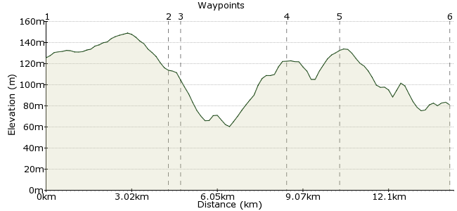
Ascent
82m (269ft)
Descent
83m (272ft)
Max. Elevation
150m (492ft)
Altitude Gain & Loss
165m (541ft)
Start & End
East Lindsey
Distance
14.40km
(8.95mi)
(8.95mi)
Duration
~4:30h
Difficulty
Moderate
Ordnance Survey Map
Starting from Ludford, cross country to Tealby and the oldest thatched pub in Lincolnshire (fantastic food and real ale!) Back across the undulating Lincolnshire Wolds and looping back around to pass Stainton le Vale and through Kirmond Mire and Thorpe Le Vale before finishing back at Ludford.
An easy to moderate walk linking up villages and Hamlets in the beautiful Lincolnshire Wolds with great views all the way across to Lincolnshire Cathedral.
Walk Functions
Share
Nearby Walks
A walk in the Wolds
A moderate, linear walk (countryside) starting in Lincolnshire, England, about 10.90km (6.77 mi) long, duration: ~3:00h.Saltfleetby Dunes
A moderate, circular walk (coast) starting in Lincolnshire, England, about 14.50km (9.01 mi) long, duration: ~4:15h.Hopping along the Norfolk coast
A moderate, linear walk (coast) starting in Norfolk, England, about 14.10km (8.76 mi) long, duration: ~4:15h.Walk Map
- $walk->POI array(0)
Waypoints
OS Grid TF196888
Take the bus to the Community Centre, Ludford.
OS Grid TF157907
Detour to Kings Head pub.
About 4.32 km (~2.68 miles) from 
OS Grid TF155905
Kings Head, Tealby (great food and real ale).
About 0.33 km (~0.21 miles) from 
OS Grid TF174938
Bypass Stainton le Vale (alternatively you can detour into the village if you wish).
About 3.80 km (~2.36 miles) from 
OS Grid TF188926
Through Kirmond le Mire following the river to Thorpe le Vale.
About 1.85 km (~1.15 miles) from 
 Finish
OS Grid TF199889
Finish back at the Community Centre, Ludford.
About 3.86 km (~2.4 miles) from 

2 comments... join the discussion!
fizzio
Last way point now edited in to correct walk length (mileage)
fizzio
The Synopsis of this walk states that it is around 8 miles but it is 10.6 miles (maybe because I didn't include a waymark at he finish?)