Morrone from Braemar
A moderate walk (mountain (above 600m)) in national park Cairngorms in Aberdeenshire, Scotland, about 13.20km (8.20 mi) long with an estimated walking time of about 5:30h. It is unsuitable for families with children, prams & pushchairs, wheelchairs.
Elevation Profile
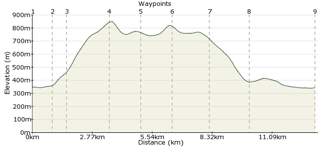
Ascent
557m (1827ft)
Descent
560m (1837ft)
Max. Elevation
860m (2821ft)
Altitude Gain & Loss
1117m (3664ft)
Start & End
Braemar
Distance
13.20km
(8.2mi)
(8.2mi)
Duration
~5:30h
Difficulty
Moderate
Ordnance Survey Map
Morrone - known as Morven to some - is the peak just to the south of Braemar. It's a straightforward day in the hills, but still enough to be a full day out (especially in winter conditions). The route leads to the summit, with fine views back across the town, then continues on the high ground to Carn na Drochaide before returning via Glen Clunie.
Walk Functions
Share
Nearby Walks
Beinn a' Bhuird
A strenuous, circular walk (mountain (above 600m)) starting in Aberdeenshire, Scotland, about 28.10km (17.46 mi) long, duration: ~10:45h.Ben Macdui from the north
A moderate, circular walk (mountain (above 600m)) starting in Highlands, Scotland, about 15.60km (9.69 mi) long, duration: ~6:30h.Braeriach
A strenuous, circular walk (mountain (above 600m)) starting in Highlands, Scotland, about 20.00km (12.43 mi) long, duration: ~8:30h.Walk Map
- $walk->POI array(0)
Waypoints
OS Grid NO148913
Take the bus to Braemar.
OS Grid NO149904
Head along Cluniebank Road to the golf course. Look for the track just before the club house.
About 0.96 km (~0.6 miles) from 
OS Grid NO143904
Where the path splits, take the left fork leading uphill.
About 0.56 km (~0.35 miles) from 
OS Grid NO132886
It's a steady slog up to the summit.
About 2.10 km (~1.3 miles) from 
OS Grid NO131873
Descend via the track into the col.
About 1.31 km (~0.81 miles) from 
OS Grid NO126860
Turn right in the col to head towards the day's second summit of Carn na Drochaide.
About 1.38 km (~0.86 miles) from 
OS Grid NO133875
Retrace your steps back to the col, then look for the path heading down the spur.
About 1.70 km (~1.06 miles) from 
OS Grid NO151881
Follow the spur to the military road that runs along the glen.
About 1.89 km (~1.17 miles) from 
 Braemar again
OS Grid NO150912
Although it's a bit of a long way along the road back, it's hard to complain with scenery like this.
About 3.04 km (~1.89 miles) from 
