Llangernyw
A leisurely walk (countryside) in Clwyd, Wales, about 6.10km (3.79 mi) long with an estimated walking time of about 2:00h. It is suitable for families with children, but unsuitable for prams & pushchairs, wheelchairs.
Elevation Profile
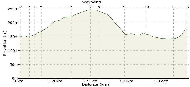
Ascent
131m (429ft)
Descent
110m (360ft)
Max. Elevation
250m (820ft)
Altitude Gain & Loss
241m (789ft)
Start & End
Llangernyw
Distance
6.10km
(3.79mi)
(3.79mi)
Duration
~2:00h
Difficulty
Leisurely
Ordnance Survey Map
 1Created by driver 16 on 12 Sep 2014
A short walk which packs in a lot, visit St. Digian's Churchyard, home to Sandbach family's Mausoleum, Liverpool trader who bought Hafodunos Hall in 1831, home also to largest, oldest, over 4000 years, yew tree, village museum of Sir Henry Jones, a forefather of Welsh education, walk up by stream to Hafodunos Hall grounds, through the woods of Hall, over bridges, by drops into ravines protected by guardrails, up flights of steps, through fields and back through meadows in Elwy valley.
Walk Functions
Share
Nearby Walks
Eglwysbach
A leisurely, circular walk (countryside) starting in Clwyd, Wales, about 5.70km (3.54 mi) long, duration: ~2:00h.Red John's Chair
A leisurely, circular walk (low hills and fells (below 600m)) starting in Clwyd, Wales, about 3.30km (2.05 mi) long, duration: ~1:15h.Llanrwst and Trefriw
A leisurely, circular walk (countryside) starting in Clwyd, Wales, about 8.00km (4.97 mi) long, duration: ~2:30h.Walk Map
- $walk->POI array(0)
Waypoints
OS Grid SH874674
Only a short walk of 4 miles which ties in with local Mon-Sat bus service, one bus in arrives 12.00hrs., one bus out leaves 15.59hrs., but, picturesque and interesting.
OS Grid SH875674
Sandbach family's Mausoleum and oldest Yew tree.
About 0.06 km (~0.04 miles) from 
OS Grid SH874672
One of the forefathers of Welsh education, interesting book, Old Memories ISBN 1-84047-006-2 and small annex to history of Hafodunos Hall, £2.50 guided tour.
About 0.22 km (~0.14 miles) from 
OS Grid SH873673
To the right of old, empty Bridge Pub, follow stream, cross 2nd. footbridge, follow path up to road, turn left to see gatehouse to Hall.
About 0.14 km (~0.09 miles) from 
OS Grid SH871673
Enter through small gate on left, short distance to sign NO ADDMITANCE to Hall, bear left signed into woods, over bridges, above drops with guardrails (watch children), up flights of steps to exit into fields.
About 0.18 km (~0.11 miles) from 
OS Grid SH866664
Walk through 2 fields to road.
About 1.03 km (~0.64 miles) from 
OS Grid SH865657
Turn left, follow to grassy triangle.
About 0.64 km (~0.4 miles) from 
OS Grid SH868659
Turn right down lane marked unsuitable for motor vehicles, keep right, it peters out into grassy lane for last few hundred yards to meet main road.
About 0.30 km (~0.19 miles) from 
OS Grid SH875663
Turn right, on left see sign for Gwytherin, follow to junction with road, bear left on road to footpath on left just before bridge over river.
About 0.81 km (~0.5 miles) from 
OS Grid SH882666
Follow through meadow to next roadbridge over river.
About 0.76 km (~0.47 miles) from 
OS Grid SH876673
See small footbridge on left, cross up to stile onto road, turn left on road back into village.
About 0.92 km (~0.57 miles) from 
 End of walk.
OS Grid SH873675
By village shop opposite The Old Stag, time for a pint ? if closed, free water from tap in wall opposite or visit shop, bench by shop, have to signal bus driver to alight, hope you enjoyed.
About 0.42 km (~0.26 miles) from 
