Braeriach
A strenuous walk (mountain (above 600m)) in national park Cairngorms in Highlands, Scotland, about 20.00km (12.43 mi) long with an estimated walking time of about 8:30h (1 overnight stay). It is unsuitable for families with children, prams & pushchairs, wheelchairs.
Elevation Profile
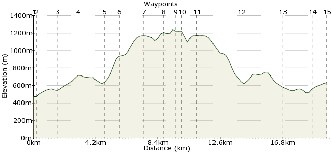
Ascent
957m (3139ft)
Descent
798m (2618ft)
Max. Elevation
1250m (4101ft)
Altitude Gain & Loss
1755m (5757ft)
Start & End
Sugarbowl car park
Distance
20.00km
(12.43mi)
(12.43mi)
Duration
~8:30h
Difficulty
Strenuous
Ordnance Survey Map
Scotland's third-highest mountain rises up above the mighty Lairig Ghru valley in the heart of the Cairngorms. It's a long day out but there are no major obstacles except the rocky Chalamain Gap, which most experienced walkers should have no problem getting through. Buses from Aviemore go to the Cairn Gorm ski centre near the start point. Note, this is a demanding and long walk. it's best done in good weather, and aim to take the first bus of the day to ensure you don't miss the last bus back! Well worth booking a bed for the night in Glenmore just in case.
Walk Functions
Share
Nearby Walks
Ben Macdui from the north
A moderate, circular walk (mountain (above 600m)) starting in Highlands, Scotland, about 15.60km (9.69 mi) long, duration: ~6:30h.A Plan B in the Cairngorms
A moderate, linear walk (mountain (above 600m)) starting in Highlands, Scotland, about 13.80km (8.57 mi) long, duration: ~5:30h.Eagle Corrie from Glenmore
A moderate, circular walk (low hills and fells (below 600m)) starting in Highlands, Scotland, about 13.20km (8.20 mi) long, duration: ~4:45h.Walk Map
- $walk->POI array(0)
Waypoints
OS Grid NH985073
Start at the Sugarbowl car park. Ask the bus driver if you can be dropped here, otherwise it's a short walk down from the ski centre.
OS Grid NH983071
Cross the river via the footbridge then follow the path around the reindeer enclosure.
About 0.31 km (~0.19 miles) from 
OS Grid NH974063
A clear, well-maintained path leads southwest towards the hills.
About 1.24 km (~0.77 miles) from 
OS Grid NH964052
Head through the Chalamain Gap. Note that the rocks can be hard to get through in bad weather as they get quite slippery.
About 1.42 km (~0.88 miles) from 
OS Grid NH958037
Cross over the northern end of the Lairig Ghru.
About 1.61 km (~1 miles) from 
OS Grid NH958027
Once across, climb steadily up the flank of the hill. The path is still good here.
About 0.95 km (~0.59 miles) from 
OS Grid NH964012
Continue up to Sron na Lairige, with fantastic views into the glen.
About 1.60 km (~0.99 miles) from 
OS Grid NN961999
It's a final push from the end to the summit of Braeriach.
About 1.32 km (~0.82 miles) from 
OS Grid NN953999
The mountain, Scotland's third highest, reveals its true character for the first time from the top, with its imposing corrie visible for the first time on the route.
About 0.76 km (~0.47 miles) from 
OS Grid NH958000
There's no way into the Lairig Ghru without extending the day greatly, so retrace your steps along the ridge.
About 0.48 km (~0.3 miles) from 
OS Grid NH965007
The retreat is a bit easier on the legs and the views are still as good.
About 0.98 km (~0.61 miles) from 
OS Grid NH957035
The climb in and out of this valley is going to sting this time around...
About 2.87 km (~1.78 miles) from 
OS Grid NH970059
Take care returning through the Chalamain Gap with tired legs.
About 2.79 km (~1.73 miles) from 
OS Grid NH987070
It's a choice here - up to the car park for the bus, or downhill to Glenmore (2km). Don't rely on the bus stopping if you flag it down! There is a path through the woods down into Glenmore.
About 1.92 km (~1.19 miles) from 
 Ski centre
OS Grid NH989060
Return to the ski centre fo the bus back to the towns.
About 1.05 km (~0.65 miles) from 
