Gomshall to Westhumble
A moderate walk (low hills and fells (below 600m)) starting and finishing in Surrey, England, about 11.90km (7.39 mi) long with an estimated walking time of about 3:45h. It is suitable for families with children, but unsuitable for prams & pushchairs, wheelchairs.
Elevation Profile
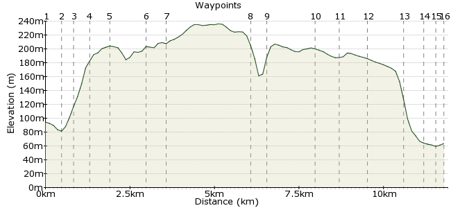
Ascent
132m (433ft)
Descent
162m (531ft)
Max. Elevation
240m (787ft)
Altitude Gain & Loss
294m (964ft)
Start
Gomshall
End
Westhumble
Distance
11.90km
(7.39mi)
(7.39mi)
Duration
~3:45h
Difficulty
Moderate
Ordnance Survey Maps
 3Created by John Walker on 08 Nov 2014
This walk starts at Gomshall, in the Tilingbourne Valley, then climbs to the North Downs ridge, staying on a level track for some 10km before descending gently to Westhumble, where the River Mole cuts through the Downs. The path is through the Surrey Hills Area of Outstanding Natural Beauty and Surrey is the most heavily wooded English county. The tree-covered hillsides almost completely mask any signs of human habitation, although a main road, a railway line and several commuter villages are hidden somewhere in the valley below you.
To reach Gomshall you can take a train from Clapham Junction to Redhill then another short ride to Gomshall station but note this latter service runs only 2 hourly. Alternatively there is an hourly bus service between Guildford and Redhill which passes through Gomshall.
Walk Functions
Share
Nearby Walks
Surrey Hills and Ales
A moderate, circular walk (countryside) starting in Surrey, England, about 17.20km (10.69 mi) long, duration: ~5:45h.A taste of the Surrey Sandstone Hills
A leisurely, circular walk (countryside) starting in Surrey, England, about 6.80km (4.23 mi) long, duration: ~2:15h.Dorking to Gomshall - walk the chalk
A moderate, linear walk (woodland) starting in Surrey, England, about 9.70km (6.03 mi) long, duration: ~3:15h.Walk Map
- $walk->POI array(0)
Waypoints
OS Grid TQ088478
From the train station turn left out of the exit down a lane to join a main road where you turn right.
OS Grid TQ084479
Turn right up Colekitchen Lane which becomes a steep hollow way.
About 0.47 km (~0.29 miles) from 
OS Grid TQ085482
Turn left off the road at a track leading to several houses.
About 0.34 km (~0.21 miles) from 
OS Grid TQ082486
Continue on the track past the last house (Hillside), up through woodland, finally turning right to join the NDW on metalled path on a level through open woods, mainly beech, yew and oak.
About 0.50 km (~0.31 miles) from 
OS Grid TQ083492
This part of the path, across Netley Heath, is labelled on the OS map as a droveway, formerly used to transport animals on the hoof from farm to market. At Little Kings Wood there is a sudden opening in the trees giving a fine view down into the valley to Colekitchen Farm and south across the Tillingbourne valley to the wooded hills of the Greensand Ridge.
About 0.56 km (~0.35 miles) from 
OS Grid TQ093491
Soon after this viewpoint the NDW turns right off the metalled track. The woodland walk crosses several small open areas with good views. There are useful information panels within the National Trust land on Hackhurst Down about wildlife, geology and land use. Walkers in southern Britain tend to take chalk downland for granted, in fact it is very unusual globally and not at all widespread. Over half the world total is in England.
About 0.93 km (~0.58 miles) from 
OS Grid TQ096487
The track is punctuated by more than a dozen pillboxes, part of a WWII ‘stop line’ defence. Some of these are now preserved monuments.
About 0.55 km (~0.34 miles) from 
OS Grid TQ120493
Coming to a gate at White Downs the path follows a (boundary?) bank and ditch before turning right along a level section. There had been many large trees downed in recent storms, some trees blocking the original path so makeshift detours have evolved. Take care not to lose the true NDW track here.
About 2.46 km (~1.53 miles) from 
OS Grid TQ124496
On an open down near Picketts Hole we watched a lazily circling buzzard riding a thermal for ages. Here also belted Galloway cattle are being used by the National Trust to browse the downland.
About 0.46 km (~0.29 miles) from 
OS Grid TQ135502
After a long straight woodland stretch the path opens out onto Ranmore Common and Denbies Hillside, with great views of Dorking and the landscape far beyond, even to the South Downs.
About 1.32 km (~0.82 miles) from 
OS Grid TQ143503
The path meets and crosses Ranmore Road, then following a quiet minor road past St. Barnabas Church (open for a much appreciated tea stop when we were there).
About 0.78 km (~0.48 miles) from 
OS Grid TQ150507
This road passes the big house and estate of ‘Denbies’ and then soon after the track turns right, down a narrow alleyway, shortly turning left onto a metalled section above the Denbies Vineyard (the largest in Britain).
About 0.75 km (~0.47 miles) from 
OS Grid TQ158509
The path sweeps round and descends gently until just past the entrance to the vineyard the houses of Westhumble appear.
About 0.91 km (~0.57 miles) from 
OS Grid TQ162514
After a further 300m watch out for a footpath sign to the left, heading across a field to a narrow path between houses.
About 0.67 km (~0.42 miles) from 
OS Grid TQ163516
This path crosses a road to another narrow section between gardens before reaching a road where you turn right.
About 0.25 km (~0.16 miles) from 
 Westhumble station
OS Grid TQ165518
A footpath is separated from the road until another road junction where the road crosses the railway line. Cross the bridge and turn right to reach Westhumble and Box Hill train station. The attractive building has few rail facilities but does have a combined cycle shop and café. There is an hourly service to Clapham Junction.
About 0.26 km (~0.16 miles) from 
