Trefriw to Llanrwst via Llyn Geirionydd
A moderate walk (countryside) in national park Snowdonia in Clwyd, Wales, about 10.30km (6.40 mi) long with an estimated walking time of about 3:30h. It is unsuitable for families with children, prams & pushchairs, wheelchairs.
Elevation Profile
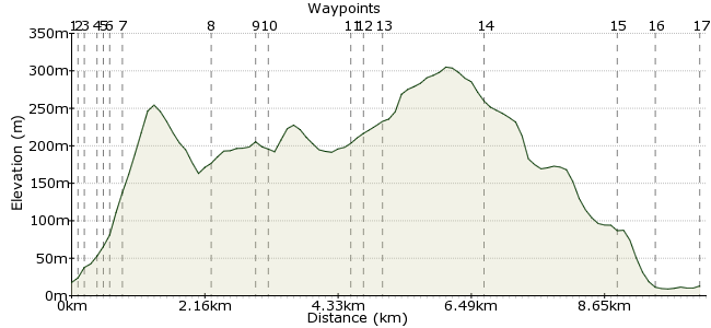
Ascent
254m (833ft)
Descent
259m (849ft)
Max. Elevation
310m (1017ft)
Altitude Gain & Loss
513m (1682ft)
Start & End
Trefriw
Distance
10.30km
(6.4mi)
(6.4mi)
Duration
~3:30h
Difficulty
Moderate
Ordnance Survey Map
 1Created by driver 16 on 16 Nov 2014
Easier and far more attractive walk than my other walk to Lake Crafnant from Trefriw, from local Newspaper, but, first 1/3 (1 1/2 hours) was as stated, then, very ambiguous, if you are not prepared for second 2/3 long walk (3 hours) into Llanrwst, suggest you retrace path down from Lake the way you came (about 1 hour).
Walk Functions
Share
Nearby Walks
10+1 lakes in Gwydi forest above Trefriw
A moderate, circular walk (mountain (above 600m)) starting in Clwyd, Wales, about 17.70km (11.00 mi) long, duration: ~6:00h.Lake Crafnant
A moderate, circular walk (mountain (above 600m)) starting in Clwyd, Wales, about 10.10km (6.28 mi) long, duration: ~3:30h.East Llanrwst
A moderate, circular walk (countryside) starting in Clwyd, Wales, about 10.70km (6.65 mi) long, duration: ~3:30h.Walk Map
- $walk->POI array(0)
Waypoints
OS Grid SH780630
Face the Woolen Mill, cross road, turn right over bridge, to corner opposite Fairy Falls Hotel.
OS Grid SH780631
Turn left uphill, short distance to rear of buildings, see footpath sign we're on trail No. 5.
About 0.12 km (~0.07 miles) from 
OS Grid SH779631
Where the path forks keep right, follow river up to Fairy Falls, History Board and bench here, bear sharp right uphill to footbridge over river, cross, straight ahead peters out to grassy lane which meets road.
About 0.06 km (~0.04 miles) from 
OS Grid SH778629
Cross over see waypost trail 5.
About 0.17 km (~0.11 miles) from 
OS Grid SH779629
See waypost Trail 5 straight ahead.
About 0.05 km (~0.03 miles) from 
OS Grid SH778629
Turn right, short distance on left waypost Trail 5 into woods.
About 0.05 km (~0.03 miles) from 
OS Grid SH777629
Follow, ignore branch left waypost Trail 5 keep right, well defined path rises through woods, with great views into Crafnant Valley.
About 0.11 km (~0.07 miles) from 
OS Grid SH766621
On well defined grassy path up to lake.
About 1.35 km (~0.84 miles) from 
OS Grid SH765614
Cross outfall to visit Monument.
About 0.66 km (~0.41 miles) from 
OS Grid SH763614
Waypost to walk path on lakeside, but, has A4 laminated paper sign in Welsh suggesting don't attempt, but, me being adventurous got as far as rocky outcrop which I didn't want to attempt, had to return to entrance to Lake and walked on tarmac to end of Lake.
About 0.18 km (~0.11 miles) from 
OS Grid SH760601
This is where the Newspaper walk got ambiguous, followed my nose, first to right to see Children's Wood, whenever a child is born / adopted the Forestry Commission plant a tree (don't be confused by sign as Welsh for child is PLANT).
About 1.34 km (~0.83 miles) from 
OS Grid SH762603
If you don't want long walk into Llanrwst return now the way you came, otherwise follow grassy path in semi-circle, see lots of Funghi on way to meet tarmac road.
About 0.20 km (~0.12 miles) from 
OS Grid SH763600
Turn left to follow past Llyn Bodgynydd (peat bog of the future), spoil heaps from old mine, left at junction to see old mine buildings with history board, past Llyn Sarnau see walk Llugwy and Gwydyr.
About 0.28 km (~0.17 miles) from 
OS Grid SH777592
Keep on tarmac road, straight ahead past roadsign for Llanrhychwyn, where if you think you have time, turn left to visit Old Grey Mare's waterfall, which would take you onto lower road into Llanrwst.
About 1.65 km (~1.03 miles) from 
OS Grid SH788609
If you visit waterfall, come back up to pass old mine Hafna on last leg into Llanrwst.
About 2.02 km (~1.26 miles) from 
OS Grid SH793610
Straight ahead to cross bridge over river, turn left, pass Eagles' Hotel into town square, right and right again at next junction to see main bus stop on left.
About 0.55 km (~0.34 miles) from 
 Main bus stop.
OS Grid SH799616
End of walk, hope you are not too tired and enjoyed.
About 0.73 km (~0.45 miles) from 
