North Downs Way: Boxhill to Reigate
A moderate walk (low hills and fells (below 600m)) starting and finishing in Surrey, England, about 11.70km (7.27 mi) long with an estimated walking time of about 4:00h. It is suitable for families with children, but unsuitable for prams & pushchairs, wheelchairs.
Elevation Profile
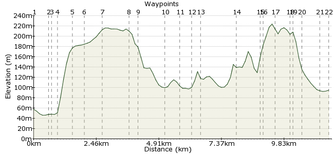
Ascent
323m (1059ft)
Descent
286m (938ft)
Max. Elevation
230m (754ft)
Altitude Gain & Loss
609m (1997ft)
Start
Westhumble
End
Reigate
Distance
11.70km
(7.27mi)
(7.27mi)
Duration
~4:00h
Difficulty
Moderate
Ordnance Survey Map
 3Created by John Walker on 23 Nov 2014
This stage of the North Downs Way starts in the River Mole valley and climbs steeply to the top of Box Hill. Then the path follows the scarp slope of the Downs with great views to the south.
There is a reasonable train service, taking only around 40 minutes, from Clapham Junction to Box Hill & Westhumble station. At this station there is an excellent combined cycle shop and tea room, ideally positioned to fuel yourself before the walk. The walk ends at Reigate station with good train links back to London or elsewhere.
Walk Functions
Share
Nearby Walks
Up Box Hill the easy way
A moderate, circular walk (countryside) starting in Surrey, England, about 10.80km (6.71 mi) long, duration: ~3:45h.Dorking to Reigate via Box Hill
A moderate, linear walk (low hills and fells (below 600m)) starting in Surrey, England, about 12.20km (7.58 mi) long, duration: ~4:00h.Dorking to Gomshall - walk the chalk
A moderate, linear walk (woodland) starting in Surrey, England, about 9.70km (6.03 mi) long, duration: ~3:15h.Walk Map
- $walk->POI array(0)
Waypoints
OS Grid TQ167518
Leave the station and turn right along Westhumble Rd. Walk past the Stepping Stones pub then find an underpass under the busy dual carriageway A24.
OS Grid TQ170513
Turn right out of the underpass and walk alongside the main road for around 400m, on a footpath a few metres away from busy road.
About 0.59 km (~0.37 miles) from 
OS Grid TQ172513
Turn left at a car park, signed Stepping Stones and NDW. A row of closely spaced concrete stumps allow one person at a time to cross the surprisingly limpid River Mole, now clean and home to a huge range of fish species.
About 0.15 km (~0.09 miles) from 
OS Grid TQ173512
Almost immediately after the river the path heads up what is probably the steepest section on the whole NDW, Box Hill. Steps (275 of them) take the path up 120m in elevation in a little over 300m horizontally. Even fit walkers need to stop for a breather.
About 0.18 km (~0.11 miles) from 
OS Grid TQ179512
The path finally emerges on flat land, along the edge of the scarp face of the Downs, with open grassland giving great views down to Dorking, up the Tillingbourne valley to the left and off beyond Gatwick airport (near the source of the Mole) to the hazy outline of the South Downs.
About 0.51 km (~0.32 miles) from 
OS Grid TQ183512
From here there is a long level stretch in a wood of mixed beech and yew, paralleling a B-road but well away from it.
About 0.41 km (~0.25 miles) from 
OS Grid TQ188512
Leaving the road but maintaining a contour the Way descends slightly to a T-junction of paths. Turn left uphill here then bear right at the next junction to follow a wooden fence behind which there is a discreet mobile home park.
About 0.51 km (~0.32 miles) from 
OS Grid TQ198514
You next reach a bench with another fine view down to the village of Brockham. Just behind the bench is a half-hidden memorial to a racehorse named ‘Quick’.
About 1.04 km (~0.65 miles) from 
OS Grid TQ201512
Brockham Quarry, now a nature reserve, had a long history of lime production and a preserved kiln remains. The nature reserve has public open days and bat walks. The path continues past more disused quarries down a narrow valley between high mounds, finally emerging by a row of Victorian terraced cottages.
About 0.34 km (~0.21 miles) from 
OS Grid TQ210516
At the junction between The Coombe and Station Rd. turn left up the hill. This road becomes Pebblehill Rd. and after a while there is a separate footpath to the left of the road.
About 0.95 km (~0.59 miles) from 
OS Grid TQ213521
On rejoining the road continue until a NDW fingerpost points down a lane to the right.
About 0.60 km (~0.37 miles) from 
OS Grid TQ218521
After 500m this track goes left through a style, heading up towards Dawcombe Wood.
About 0.43 km (~0.27 miles) from 
OS Grid TQ218524
Just at the end of the field the path goes right, continuing on a level contour.
About 0.28 km (~0.17 miles) from 
OS Grid TQ231523
The path continues around the bulging base of Juniper Hill, then entering a darker section of wood and arriving at a cross-roads of paths.
About 1.36 km (~0.85 miles) from 
OS Grid TQ239519
The North Downs Way is not properly signed here but take the left fork of the two paths ahead, rising up quite steeply. After a few hundred yards the main path turns sharp left. There is a narrow track going straight ahead here and this is a short but even steeper cut to the top of Colley Hill.
About 0.84 km (~0.52 miles) from 
OS Grid TQ240521
We followed the main track which dog legs up to the same point. The summit of Colley Hill is an open tree lined track giving way to an open meadow with more stunning views, now over Reigate and beyond.
About 0.19 km (~0.12 miles) from 
OS Grid TQ243523
The M25 is only yards away, to the north. This is National Trust land and is being grazed by the distinctive black and white Belted Galloway cows. Just beyond a water tower and view point the path bears right on level open ground.
About 0.39 km (~0.24 miles) from 
OS Grid TQ248520
For the descent to Reigate station look out for a fingerpost about 300m beyond this point, and a track forking right downhill.
About 0.55 km (~0.34 miles) from 
OS Grid TQ249519
The path enters woodland on a high brick supported stretch, emerging to bend around a simple stone memorial to a soldier, erected in 1910. At this point take the right hand lower chalky path which becomes narrow and rutted as it descends the hillside, emerging through woodland into a car park.
About 0.18 km (~0.11 miles) from 
OS Grid TQ250516
Go straight ahead down a wide grass-verged road, passing large detached houses.
About 0.28 km (~0.17 miles) from 
OS Grid TQ249510
In around 800m, just before the railway line, turn left into Somers Road.
About 0.67 km (~0.42 miles) from 
 Reigate station
OS Grid TQ252508
After another 500m turn right at the junction with Reigate Hill then almost immediately left to reach Reigate Station. There are frequent trains to Redhill (the next stop) from where there is a good service to Clapham Junction and elsewhere.
About 0.37 km (~0.23 miles) from 
