Heddon on the Wall Circular
A moderate walk (countryside) in Northumberland, England, about 12.40km (7.71 mi) long with an estimated walking time of about 3:45h. It is unsuitable for families with children, prams & pushchairs, wheelchairs.
Elevation Profile
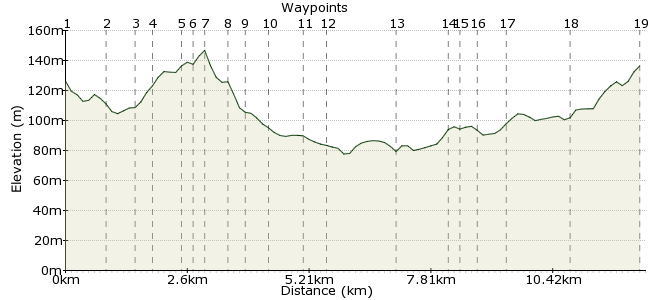
Ascent
96m (314ft)
Descent
104m (341ft)
Max. Elevation
150m (492ft)
Altitude Gain & Loss
200m (655ft)
Start & End
Heddon on the Wall
Distance
12.40km
(7.71mi)
(7.71mi)
Duration
~3:45h
Difficulty
Moderate
Ordnance Survey Map
This walk explores the countryside to the north of Heddon on the Wall. It follows public footpaths but it can be quite wet and muddy after rain
Walk Functions
Share
Nearby Walks
Jesmond Dene
A leisurely, linear walk (city/town) starting in Tyne and Wear, England, about 4.70km (2.92 mi) long, duration: ~1:15h.Millennium walk
A leisurely, linear walk (riverside) starting in Tyne and Wear, England, about 9.00km (5.59 mi) long, duration: ~2:30h.Monkton meander
A leisurely, circular walk (riverside) starting in Tyne and Wear, England, about 9.30km (5.78 mi) long, duration: ~2:30h.Walk Map
- $walk->POI array(0)
Waypoints
OS Grid NZ133670
The Walk starts at the Knott Memorial Hall. Cross the road and take the track leading to Bay's Leap Farm. Walk on to the bridge taking the A69 over the track
OS Grid NZ129677
Go under the bridge and turn almost immediately right through a small gate to take a path slightly uphill and through a small wood. Follow this path alongside the A69 to the slip road
About 0.82 km (~0.51 miles) from 
OS Grid NZ135678
At the slip road take the minor road north for about 250m. Take the track on the right signed Heddon Sports Field. Go through the gate and continue through the next gate and continue to a path on L.
About 0.56 km (~0.35 miles) from 
OS Grid NZ138680
Cross the stile and take the path to Sunniside. Here cross the track and continue north until the path is signed to turn right.
About 0.38 km (~0.24 miles) from 
OS Grid NZ136686
Cross the stile into the field and locate the next stile ahead, and make for it. The ground is very rough and wet n this stretch
About 0.61 km (~0.38 miles) from 
OS Grid NZ137687
Cross the stile and follow the single strand barbed wire fence to the left to its end. Make for the buildings visible ahead.
About 0.16 km (~0.1 miles) from 
OS Grid NZ139689
The stile is over the wall into a small enclosure. Exit the enclosure by a gate in the right hand corner. Walk along the access road to the farm track ahead and walk to Heddon Laws farm
About 0.26 km (~0.16 miles) from 
OS Grid NZ140692
Walk about 50m past the entrance to the farm and take the foot path on the left heading north. The ath follows the hedge on the left until the hedge diverts to the left. Head for the gate ahead
About 0.31 km (~0.19 miles) from 
OS Grid NZ140696
Go over the stile into the road. Cross over and follow the minor road for about 250m to a stile in the hedge. Go through and follow the path downhill to a ladder stile seen in the distance
About 0.39 km (~0.24 miles) from 
OS Grid NZ138700
Cross the ladder stile and follow the deep drainage ditch to a small gate with a footpath sign. It is easier on the left of the ditch. Go through the gate and follow a single line footpath to a stile
About 0.47 km (~0.29 miles) from 
OS Grid NZ139707
The path has been diverted around the field so follow the diversion all of the way around until a stile is found on the left. Cross and follow the field edge to the track to Donkins House farm.
About 0.71 km (~0.44 miles) from 
OS Grid NZ140712
Follow this track to the farm and follow the diversion requested by the farmer. Continue on this track to the road
About 0.50 km (~0.31 miles) from 
OS Grid NZ127707
At the road turn right and walk on over Dissington Bridge and on to the road to Eachwick. Turn left and walk to Eachwick
About 1.40 km (~0.87 miles) from 
OS Grid NZ117710
Take the path on the left. It follows the hedge but is not visible on the ground. It is also often blocked by temporary horse fences. Carry on to the end of the hedge and a stile on the right
About 1.04 km (~0.65 miles) from 
OS Grid NZ118708
ross the stile and immediately after cross the footbridge. There is a faint path leading to the left around the field boundary towards the woods visible ahead. Just past the woods there is a stile on the left
About 0.30 km (~0.19 miles) from 
OS Grid NZ119705
Cross the stile and walk towards South Dissington Farm. The path has been diverted around the farm buildings but the diversions bring the path onto the farm access road
About 0.34 km (~0.21 miles) from 
OS Grid NZ122700
Follow the access road to the public road and the ornamental gates. Turn Right and then left onto the path to West Heddon. At this farm go onto the access road
About 0.51 km (~0.32 miles) from 
OS Grid NZ123687
Turn half left and walk to the stile and cross. Carry on to the corner of the field and cross another stile. Turn right and cross a third stile. Follow the faint path. This leads to the Road Bridge.
About 1.35 km (~0.84 miles) from 
 Road Bridge
OS Grid NZ130675
Pass under the road bridge and continue on the track until the road is reached .Cross the road to return to the Knott Memorial Hall and the end of the walk.
About 1.41 km (~0.88 miles) from 

1 comment... join the discussion!
David Sturman
My 2 friends and I did this walk yesterday (30/11/2016). It is not a walk for the faint hearted. The signage (waymarkers) are missing in numerous places, the styles are danegerous and drastic need of attention, in some cases they have been over grown with bushes, and there are numerous diversions. Most of the meadow land is very uneven. It would seem that the more inaccesible parts have not been walked for years. The walk is glorious and well worth the effort. Now we have done it and and know where to go we will do it again in Summer 2017.