Dent to Ribblehead via Great Knoutberry Hill
A moderate walk (mountain (above 600m)) in national park Yorkshire Dales starting and finishing in Cumbria, England, about 15.00km (9.32 mi) long with an estimated walking time of about 6:00h. It is unsuitable for families with children, prams & pushchairs, wheelchairs.
Elevation Profile
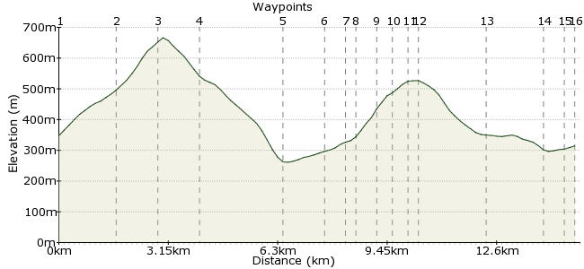
Ascent
596m (1955ft)
Descent
629m (2063ft)
Max. Elevation
670m (2198ft)
Altitude Gain & Loss
1225m (4018ft)
Start
Dent Railway Station
End
Chapel le Dale
Distance
15.00km
(9.32mi)
(9.32mi)
Duration
~6:00h
Difficulty
Moderate
Ordnance Survey Map
 2Created by mac.hawk on 09 Dec 2014
Another fabulous walk from the Settle-Carlisle line. Full route approx 11 miles, suitable for older children as it's quite a steep 'up' to Great Knoutberry summit. An easier option would be to skip the summit & take the bridleway over Green Bank to the bridleway at Dent Fell & descend Arten Gill from there. 1/2 day walk in longer summer sunshine. Train the only option. No facilities on route.
Walk Functions
Share
Nearby Walks
Whernside - one of Yorkshire's Big Three
A moderate, linear walk (mountain (above 600m)) starting in North Yorkshire, England, about 14.50km (9.01 mi) long, duration: ~5:45h.Rise Hill from Dent
A moderate, circular walk (low hills and fells (below 600m)) starting in Cumbria, England, about 16.50km (10.25 mi) long, duration: ~6:15h.Garsdale circular to Great Shunner Fell summit
A strenuous, circular walk (mountain (above 600m)) starting in Cumbria, England, about 22.30km (13.86 mi) long, duration: ~8:45h.Walk Map
- $walk->POI array(0)
Waypoints
OS Grid SD763874
Exit the railway station and upon reaching the road turn right up Coal Road for a little over a mile to reach the bridleway on the right near Crosshills Wold and go through the gate.
OS Grid SD779880
Follow the bridleway for 1/2 mile to a gate and where a fence on the left runs uphill, take the access path and follow the fence quite steeply uphill for just under a mile to reach the trig pillar.
About 1.64 km (~1.02 miles) from 
OS Grid SD788871
From the trig point simply follow the wall on your left downhill to reach the bridleway at Arten Gill Moss.
About 1.26 km (~0.78 miles) from 
OS Grid SD793862
Turn right and follow downhill to pass under Arten Gill viaduct and beyond Stonehouse Farm reach the road junction.
About 1.10 km (~0.68 miles) from 
OS Grid SD770859
Turn left and follow the road for a little under a mile to reach a waymarked footpath on the right at Bridge End.
About 2.33 km (~1.45 miles) from 
OS Grid SD774847
Follow the footpath to Dent Head Farm (can be quite squishy underfoot).
About 1.25 km (~0.78 miles) from 
OS Grid SD775843
The path runs directly through the farmyard (and there's usually interesting farm birds in the yard) then follows the stream on the right, to cross via a footbridge then heads towards the woodland.
About 0.44 km (~0.27 miles) from 
OS Grid SD774839
Enter the woodland and follow the path to reach a wide track and carry on directly uphill (Dec 2014 - the trees either side of the path have been felled) to reach a stile.
About 0.39 km (~0.24 miles) from 
OS Grid SD772835
Go over the stile onto the open moor and follow the path as it continues to rise the hill ahead. Pass one of the airshafts for Blea Moor Tunnel to shortly reach a stile/fence.
About 0.48 km (~0.3 miles) from 
OS Grid SD769831
If the weather's poor carry on directly ahead over the stile, if the weather's good immediately before reaching the fence go left onto the open moor (there's a sort of raised embankment) for 1/4 mile.
About 0.46 km (~0.29 miles) from 
OS Grid SD772829
Reach the northern crags of the summit (fantastic views north and west) then turn right to reach the fence, cross and follow the path to the triangulation pillar.
About 0.37 km (~0.23 miles) from 
OS Grid SD772825
Stand and be staggered by the view. The best view of the 3 Peaks from anywhere!
Retrace your steps to the fence/stile at 10 and follow the path as it descends.
About 0.33 km (~0.21 miles) from 
OS Grid SD760812
The track descends for a little over a mile into Little Dale to eventually join a wide track that follows the railway line on the right.
About 1.82 km (~1.13 miles) from 
OS Grid SD758796
As you reach Ribblehead viaduct descend a short stepped section to reach a wide track and carry on ahead to reach the road by the Station Inn at Ribblehead.
About 1.58 km (~0.98 miles) from 
OS Grid SD763791
Turn right, go over the cattle grid and on the left turn into the access road to Ribblehead railway station (you may wish to avail yourself of the pubs services first though!)
About 0.69 km (~0.43 miles) from 
 Ribblehead Rail Station
OS Grid SD765789
The Finish - approx 11 miles if you visit Blea Moor trig.
About 0.24 km (~0.15 miles) from 
