Laxey beach to Snaefell Summit
A moderate walk (countryside) starting and finishing in Isle of Man, Isle of Man, about 9.80km (6.09 mi) long with an estimated walking time of about 4:30h. It is unsuitable for families with children, prams & pushchairs, wheelchairs.
Elevation Profile
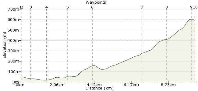
Ascent
589m (1932ft)
Descent
42m (137ft)
Max. Elevation
610m (2001ft)
Altitude Gain & Loss
631m (2069ft)
Start
Laxey
Distance
9.80km
(6.09mi)
(6.09mi)
Duration
~4:30h
Difficulty
Moderate
Ordnance Survey Map
 2Created by mac.hawk on 18 Dec 2014
A very rewarding shore to summit walk. Best undertaken when the Snaefell Mountain Railway is running (Apr to Oct) unless you fancy doubling the length and walking to ... wherever ... to get transport back.
Amazing views from Snaefell summit if you get the weather (and it's a big IF).
Suitable for active 8+ year old's and of course you could reverse the route for a somewhat easier experience.
Walk Functions
Share
Nearby Walks
Glen Mona & Port Cornaa
A leisurely, circular walk (countryside) starting in Isle of Man, England, about 9.30km (5.78 mi) long, duration: ~3:15h.Snaelfell to Laxey 'off piste' in places!
A moderate, linear walk (low hills and fells (below 600m)) starting in , , about 11.90km (7.39 mi) long, duration: ~3:30h.Southern half of The Millennium Way
A moderate, linear walk (countryside) starting in Isle of Man, England, about 15.90km (9.88 mi) long, duration: ~4:45h.Walk Map
- $walk->POI array(0)
Waypoints
OS Grid SC432844
There's a very limited bus service to Old Laxey so in all probability you'll take the bus/tram to the MER Station and walk down to the beach from there.
OS Grid SC432846
So from the MER station follow the tram lines past the Miners Tavern to soon turn right down Captain's Hill. The waterwheel that is Lady Evelyn is on the left and well worth a visit.
About 0.20 km (~0.12 miles) from 
OS Grid SC433843
At the next junction turn left down Glen Road to continue downhill to pass Laxey Woollen Mills on the left (well worth a visit) and follow the Laxey River on your right.
About 0.31 km (~0.19 miles) from 
OS Grid SC440838
Reach the bridge over the river near the Shore Inn & cross the bridge then immediately turn left down Tent Road to reach the shore. Dip a foot in the sea then return back to the top of Captain's Hill.
About 0.86 km (~0.53 miles) from 
OS Grid SC432846
At the top of Captain's Hill directly cross the road & continue up Mines Road heading towards the largest working waterwheel in the world, the Lady Isabella. Follow the road as it rises uphill.
About 1.19 km (~0.74 miles) from 
OS Grid SC430860
Upon reach Agneash village take a waymarked Greenway (Bridleway) on the left for nearly two miles to reach the old, derelict Snaefell Mines buildings.
About 1.38 km (~0.86 miles) from 
OS Grid SC407874
From the mines the route is unwaymarked and sometimes unclear (and squishy) but head initially left to soon cross a stream then diagonally left uphill towards Bungalow.
About 2.63 km (~1.63 miles) from 
OS Grid SC395867
At Bungalow take care to cross the busy road then take the wide path heading right, uphill to reach Snaefell summit.
About 1.34 km (~0.83 miles) from 
OS Grid SC397880
Pass the cafe & follow the concrete path to the trigpoint and if you're VERY lucky view the 7 Kingdoms.
About 1.33 km (~0.83 miles) from 
 MER Snaefell Terminus
OS Grid SC396879
Walk length 7 miles. If the mountain railway is running take the tram back down to Laxey, if not, well you'll have to leg it to wherever.
About 0.19 km (~0.12 miles) from 
