Giggleswick/Settle Circular
A moderate walk (countryside) in North Yorkshire, England, about 12.70km (7.89 mi) long with an estimated walking time of about 4:00h. It is unsuitable for families with children, prams & pushchairs, wheelchairs.
Elevation Profile
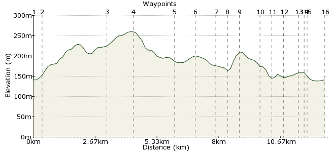
Ascent
189m (620ft)
Descent
189m (620ft)
Max. Elevation
260m (853ft)
Altitude Gain & Loss
378m (1240ft)
Start & End
Giggleswick Railway Station
Distance
12.70km
(7.89mi)
(7.89mi)
Duration
~4:00h
Difficulty
Moderate
 2Created by mac.hawk on 04 Jan 2015
9 mile circular route from either railway station on 'the other side of the line'. Mostly on road and bridleway (which can be squishy in places) but there are some fabulous views across to Ingleborough, Pen y Ghent, Fountains Fell & Warrendale Knotts and Settle's always worth an amble around.
Walk Functions
Share
Nearby Walks
Settle to Horton via Stainforth & Pen Y Ghent
A moderate, linear walk (mountain (above 600m)) starting in North Yorkshire, England, about 17.80km (11.06 mi) long, duration: ~7:00h.Settle to Grassington via Malham
A moderate, linear walk (low hills and fells (below 600m)) starting in North Yorkshire, England, about 20.80km (12.92 mi) long, duration: ~7:45h.Settle circular water walk
A moderate, circular walk (countryside) starting in North Yorkshire, England, about 9.80km (6.09 mi) long, duration: ~3:15h.Walk Map
- $walk->POI array(0)
Waypoints
OS Grid SD802629
Exit the railway station by veering right towards the bike shed and taking the steps down to the fo0tpath and turn right. Turn right again under the railway bridge for just over 1/4 mile.
OS Grid SD797628
At the junction take the left hand road (Storth Gill Lane) and simply follow for a further 2 miles to reach Sandford.
About 0.42 km (~0.26 miles) from 
OS Grid SD772621
At Sandford turn right and follow the bridleway to where it turns sharp right.
About 2.67 km (~1.66 miles) from 
OS Grid SD765630
Where the bridleway turned sharp right it also descends to a gate on the right heading for Rouster Green. Go through the gate & turn left to follow the wall to Accerhill Hall. At the road turn right.
About 1.19 km (~0.74 miles) from 
OS Grid SD774645
Follow the road to the Four Lane Ends junction and turn right along the bridleway to the junction west of Craven Ridge.
About 1.79 km (~1.11 miles) from 
OS Grid SD781640
At the junction turn left and follow a short distance to reach Craven Ridge Lane End and turn right.
About 0.87 km (~0.54 miles) from 
OS Grid SD790641
Immediately beyond Tipperthwaite Barns take a path on the left across a couple of fields to then descend to the railway line.
About 0.84 km (~0.52 miles) from 
OS Grid SD793641
Cross the railway line and ascend the embankment to the cross the A65(T) road. Follow the path to a ladder stile then carry on uphill passing to the left of a small coppice.
About 0.34 km (~0.21 miles) from 
OS Grid SD798641
From the coppice follow the path through fields heading slightly to the right of the public school chapel tower.
About 0.49 km (~0.3 miles) from 
OS Grid SD806638
After passing the Chapel tower on the left the path enters a stoney, walled lane to reach the road, turn right and follow Craven Bank Lane into Church Street to pass St Alkelda's church.
About 0.86 km (~0.53 miles) from 
OS Grid SD811640
Carry on along the road and turn (first) left up Bell Hill at the top of which turn right to pass Settle College on the right and reach the bridge over the river Ribble.
About 0.58 km (~0.36 miles) from 
OS Grid SD815640
From the bridge carry on straight across the junction up (another) Church Street and into the town centre to the Market Square. Settle town centre is always worth an amble around.
About 0.41 km (~0.25 miles) from 
OS Grid SD819636
Leave the Market Square and carry on passing the Spar and the Golden Lion pub and just beyond the pelican crossing turn right into Station Road.
About 0.54 km (~0.34 miles) from 
OS Grid SD818635
Follow the road for 250 yards to reach Settle railway station on the left.
About 0.20 km (~0.12 miles) from 
OS Grid SD816635
To return to Giggleswick rail station carry on down Station Road for 3/4 of a mile, crossing the river to reach a cross roads.
About 0.19 km (~0.12 miles) from 
 Brackenber Lane
OS Grid SD809633
At the crossroads carry on directly ahead down Brackenber Lane for 1/2 mile and at the A65(T) junction turn right very briefly and (carefully) cross the road to reach the railway station.
About 0.75 km (~0.47 miles) from 
