A wander through Brighton and Hove
A moderate walk (city/town) in Brighton and Hove, England, about 10.90km (6.77 mi) long with an estimated walking time of about 3:15h. It is unsuitable for families with children, prams & pushchairs, wheelchairs.
Elevation Profile
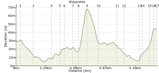
Ascent
101m (331ft)
Descent
86m (282ft)
Max. Elevation
70m (229ft)
Altitude Gain & Loss
187m (613ft)
Start & End
Hove station
Distance
10.90km
(6.77mi)
(6.77mi)
Duration
~3:15h
Difficulty
Moderate
Ordnance Survey Map
Brighton and Hove is the spiritual home of Car Free Walks. It was here that the website was planned and revised, usually in some of the pubs passed on this walk. The route heads past some tourist hotspots, a wide selection of fine watering holes, and of course along the famous seafront.
Walk Functions
Share
Nearby Walks
Hove Park Healthwalk
A leisurely, circular walk (city/town) starting in East Sussex, England, about 0.70km (0.43 mi) long, duration: ~0:00h.Brighton to Lewes (Jugg's Road)
A moderate, linear walk (low hills and fells (below 600m)) starting in East Sussex, England, about 12.60km (7.83 mi) long, duration: ~4:00h.Seafront Healthwalk
A leisurely, linear walk (coast) starting in East Sussex, England, about 1.50km (0.93 mi) long, duration: ~0:15h.Walk Map
- $walk->POI array(0)
Waypoints
OS Grid TQ289055
Start by taking the train or bus to Hove station. No walk around Brighton & Hove is complete without visiting Hove, after all...
OS Grid TQ291053
Head left out of the station and enjoy one of Hove's grand streets, The Drive.
About 0.33 km (~0.21 miles) from 
OS Grid TQ290043
At the seafront, head east along Kings Lawns. Beach huts add colour to your right, while the famous Georgian seafront houses are to the left.
About 1.00 km (~0.62 miles) from 
OS Grid TQ303040
Much beloved by photographers at sunset, this pier was burnt down in 1975 and has been in disrepair since. Attempts to restore have floundered, but the starlings love it. Watch out for their murmurations around the skeletal remains.
About 1.33 km (~0.83 miles) from 
OS Grid TQ309039
At Ship Street, cross the main seafront road and wander into The Lanes, a popular area full of restaurants and jewellers.
About 0.59 km (~0.37 miles) from 
OS Grid TQ310042
Cross North Street (watch out for buses here, they can be a bit fast) and explore the North Laine at leisure. This area is a series of parallel streets full of cafes and quirky shops, so choose your own route through them.
About 0.33 km (~0.21 miles) from 
OS Grid TQ312048
At Trafalgar Street, turn right and had downhill. Walk towards the impressive St Peter's Church, known as 'Brighton's Cathedral' and head north beyond it to an open area of grass known as The Level. Some say this area is how the crusty dogs-on-strings group The Levellers got their name...
About 0.60 km (~0.37 miles) from 
OS Grid TQ316050
You are leaving tourist territory now and entering the locals' heartland. Southover Street is a very steep hill with excellent pubs on either side. Pop in to any of them for a pint, you can't go wrong. The Greys is my personal favourite: www.thegreyspub.co.uk
About 0.46 km (~0.29 miles) from 
OS Grid TQ320047
At the top of Southover Street, head downhill again along Queen's Park Road.
About 0.56 km (~0.35 miles) from 
OS Grid TQ317039
After crossing the main road at Edward Street, you enter Kemp Town, another of Brighton's famous districts. More pubs, restaurants and general bonhomie to be found along here. Dip into the side streets as well.
About 0.83 km (~0.52 miles) from 
OS Grid TQ329035
At the end of the main throughfare along Kemp Town, turn right to reach the seafront. The giant houses around here are classic Brighton, and ridiculously expensive. Cross over Marine Parade and take the walkway down to the sea.
About 1.34 km (~0.83 miles) from 
OS Grid TQ325035
The final stage leads you back along the sea front towards the centre of Brighton again.
About 0.47 km (~0.29 miles) from 
OS Grid TQ313038
The very heart of Brighton. Famous for its key role in the book and film of Brighton Rock, and tacky fun to boot, it's worth walking to the end and eating some chips there.
About 1.20 km (~0.75 miles) from 
OS Grid TQ312041
Head back into town via the Royal Pavillion, a remarkable building whichever way you look at it.
About 0.30 km (~0.19 miles) from 
OS Grid TQ310045
Meander back through the North Laine to reach the station, choosing a different route to last time.
About 0.46 km (~0.29 miles) from 
OS Grid TQ309047
Finish up with a pint of Dark Star ale at the Evening Star, just before Brighton Station (on Surrey Street): darkstarbrewing.co.uk/the-brewery
About 0.26 km (~0.16 miles) from 
 Brighton station
OS Grid TQ310049
Head back to the station for the train home.
About 0.23 km (~0.14 miles) from 
