A long Whernside circular from Ribblehead
A strenuous walk (mountain (above 600m)) in national park Yorkshire Dales in Lancashire, England, about 24.40km (15.16 mi) long with an estimated walking time of about 8:15h (1 overnight stay). It is unsuitable for families with children, prams & pushchairs, wheelchairs.
Elevation Profile
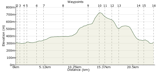
Ascent
428m (1404ft)
Descent
431m (1414ft)
Max. Elevation
730m (2395ft)
Altitude Gain & Loss
859m (2818ft)
Start & End
Ribblehead railway station
Distance
24.40km
(15.16mi)
(15.16mi)
Duration
~8:15h
Difficulty
Strenuous
Ordnance Survey Map

Walk Functions
Share
Nearby Walks
Ribblehead-Chapel-le-Dale-Ribblehead
A moderate, circular walk (countryside) starting in Lancashire, England, about 10.90km (6.77 mi) long, duration: ~3:15h.The 3 Peaks
A hard, circular walk (mountain (above 600m)) starting in Lancashire, England, about 33.20km (20.63 mi) long, duration: ~13:30h.Ingleborough from Ribblehead
A moderate, linear walk (mountain (above 600m)) starting in North Yorkshire, England, about 15.00km (9.32 mi) long, duration: ~5:30h.Walk Map
- $walk->POI array(0)
Waypoints
OS Grid SD765789
From the railway station take the access road down to The Station Inn pub and turn right briefly.
OS Grid SD763791
After the cattle grid turn left and follow the bridleway to pass under Ribblehead Viaduct.
About 0.27 km (~0.17 miles) from 
OS Grid SD758794
Continue along the bridleway to pass through Gunnerfleet farm and immediately after crossing the stream turn right.
About 0.59 km (~0.37 miles) from 
OS Grid SD752796
After crossing the stream and turning right follow the tarmac road to reach a T junction near (west of) Winterscales Farm and turn left.
About 0.63 km (~0.39 miles) from 
OS Grid SD751800
Follow the road to reach the farm at Ivescar and continue through the farm in the same direction through fields to reach Bruntscar where the route turns to walled track.
About 0.45 km (~0.28 miles) from 
OS Grid SD738790
Follow the walled bridleway to Ellerbeck Farm, pass through the farm (keep to the left), to ford Ellerbeck Gill.
About 1.65 km (~1.03 miles) from 
OS Grid SD729782
After crossing Ellerbeck Gill follow the bridleway across Scales Moor to Ewes Top. The path meanders in several places but all diversions lead to Ewes Top.
About 1.14 km (~0.71 miles) from 
OS Grid SD704760
At Ewes Top you reach the limestone pavements. Don't enter, instead veer right and head for the wall. Upon reaching the wall turn right and simply follow it uphill.
About 3.31 km (~2.06 miles) from 
OS Grid SD730796
Just keep following the wall on your left as you steadily ascend towards Whernside summit. You will join the wide '3 Peaks' footpath shortly after Combe Scar.
About 4.36 km (~2.71 miles) from 
OS Grid SD738813
At Whernside summit continue along the plateau then shortly after you start to descend keep an eye out for a stile on the left that leads to Knoutberry Hill.
About 1.91 km (~1.19 miles) from 
OS Grid SD740823
Once over the stile follow a (usually moist) path heading for the smaller of the Whernside Tarns which you will pass to the right of. The path now veers left towards the larger tarns.
About 0.98 km (~0.61 miles) from 
OS Grid SD741834
From the larger tarns the route descends towards the Boot of the Wold - look for the wall ahead (downhill) and head for that, beyond which reach a track.
About 1.14 km (~0.71 miles) from 
OS Grid SD745845
Upon reaching the wide track (Craven Way) turn right and follow to eventually reach the aqueduct over the Settle-Carlisle line.
About 1.13 km (~0.7 miles) from 
OS Grid SD760816
Beyond the Aqueduct follow the route right over Little Dale Beck and continue along the wide path to pass Blea Moor Signal Box.
About 3.21 km (~1.99 miles) from 
OS Grid SD758806
Continue along the route to descend steppings by Ribblehead viaduct after which press on ahead along the wide track to retrace your steps to Ribblehead railway station.
About 1.06 km (~0.66 miles) from 
 Riblehead Railway Station
OS Grid SD764790
Walk is approx 19 miles from/to Ribblehead Railway Station.
About 1.72 km (~1.07 miles) from 

2 comments... join the discussion!
mac.hawk
As this route describes the ascent of Whernside from Ewe's Top 'up the ridge' why you'd want to descend back the same way and extend to Ingleton is beyond me.! The 'variation' as described by RW is really only an option if you do the REVERSE of the route as described and as such would be a welcome variation (although it would shorten the route somewhat). Perhaps RW might post a route?
Ray Wilkes
A variation of this walk is to continue from Whernside summit down the ridge to Ingleton. Monday to Saturdays a bus will take you back to the Railway at Settle or Skipton.