Settle to Horton via Stainforth & Pen Y Ghent
A moderate walk (mountain (above 600m)) in national park Yorkshire Dales starting and finishing in North Yorkshire, England, about 17.80km (11.06 mi) long with an estimated walking time of about 7:00h. It is unsuitable for families with children, prams & pushchairs, wheelchairs.
Elevation Profile
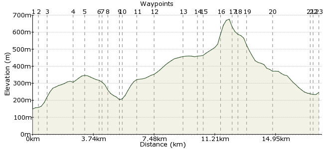
Ascent
691m (2267ft)
Descent
593m (1945ft)
Max. Elevation
680m (2230ft)
Altitude Gain & Loss
1284m (4212ft)
Start
Settle Railway Station
End
Horton in Ribblesdale
Distance
17.80km
(11.06mi)
(11.06mi)
Duration
~7:00h
Difficulty
Moderate
Ordnance Survey Map
 2Created by mac.hawk on 10 Jan 2015
A linear station to station hike from the Leeds-Settle-Carlisle line along one of the (initially at least) quieter ascents of PyG. Can be a bit squishy underfoot on the Stainforth to PyG 'nose' section in wetter times. Detour to visit St Peter's Church, Stainforth & it's wonderful Millennium (stained glass) Window thoroughly recommended. Craven Heifer pub & public toilets available in Stainforth.
Walk Functions
Share
Nearby Walks
Settle to Grassington via Malham
A moderate, linear walk (low hills and fells (below 600m)) starting in North Yorkshire, England, about 20.80km (12.92 mi) long, duration: ~7:45h.Settle circular water walk
A moderate, circular walk (countryside) starting in North Yorkshire, England, about 9.80km (6.09 mi) long, duration: ~3:15h.Giggleswick/Settle Circular
A moderate, circular walk (countryside) starting in North Yorkshire, England, about 12.70km (7.89 mi) long, duration: ~4:00h.Walk Map
- $walk->POI array(0)
Waypoints
OS Grid SD816634
Exit the railway station via the access road and turn right. At the junction with the main road turn left and reach the Market Square.
OS Grid SD819637
At the far side of the Market Square (the Co-Op side) go up Constitution Hill. At the top of it take the track (Banks Lane) that veers right & continues uphill. Go through a wide gate & press on.
About 0.43 km (~0.27 miles) from 
OS Grid SD823640
Once through the gate follow the wall on your left through 3 fields to just beyond Blua Crags where you leave the wall on the left to cross the open field to head for the woodland ahead.
About 0.46 km (~0.29 miles) from 
OS Grid SD829653
The path reaches the road just south of Cow Close. Turn right and follow the road as it immediately turns left for approx 1 mile and crosses a cattle grid.
About 1.44 km (~0.89 miles) from 
OS Grid SD833659
Just beyond the cattle grid turn left down a tarmac road for approx 1 mile to reach the farms at Winskill.
About 0.79 km (~0.49 miles) from 
OS Grid SD829665
Reach a waymarked junction & go left to follow the track to Lower Winskill farm. Go between the farm buildings to find a stile directly ahead.
About 0.74 km (~0.46 miles) from 
OS Grid SD826664
Once over the stile veer right across a couple of fields to reach woodland.
About 0.25 km (~0.16 miles) from 
OS Grid SD825666
Follow the path downhill through the woodland to enter a field and follow the fence on the right to reach the buildings at Stainforth.
About 0.22 km (~0.14 miles) from 
OS Grid SD822672
Enter the housing area and go left briefly to reach Main Road. Follow Main Road over the bridge over Stainforth Beck. At the road junction carry on ahead
About 0.68 km (~0.42 miles) from 
OS Grid SD821673
Where the main road turns sharp right (and a left leads to the Church) carry on ahead into a lane between housing to reach a gate into a field.
About 0.16 km (~0.1 miles) from 
OS Grid SD821682
The path initially heads diagonally left before turning right to climb the hill (following the Ribble Way) to follow How Beck a short distance.
About 0.84 km (~0.52 miles) from 
OS Grid SD824691
The route continues along a more level section to reach Head Lane. Cross directly & follow the path that heads diagonally left towards the wall. Continue following the wall (you cross it at Overdale)
About 0.99 km (~0.62 miles) from 
OS Grid SD830707
Now with the wall on your right continue towards Pen y Ghent to soon meet the track that is Long Lane.
About 1.71 km (~1.06 miles) from 
OS Grid SD832715
Ignore Long Lane and carry on directly ahead following the wall on the left a short distance. The wall disappears sharp left shortly.
About 0.82 km (~0.51 miles) from 
OS Grid SD832718
The temptation here is to cut the corner and cross the open moor to Gavel Rigg. Don't, it's invariably a quagmire of mush. Just follow the wall to join the Pennine way to the 'nose' of Pen y Ghent.
About 0.32 km (~0.2 miles) from 
OS Grid SD835727
Follow the obvious route up the 'nose' of Pen y Ghent. It's in 2 sections & quite steep & steppy & you might need to use your hands at times but it leads to a paved section heading to the trig point.
About 0.94 km (~0.58 miles) from 
OS Grid SD837733
From the summit go over the step stiles/gates and follow the wide, eroded path down hill.
About 0.64 km (~0.4 miles) from 
OS Grid SD836736
The route soon turns sharp right and descends a little more gently to reach a waymaker post.
About 0.30 km (~0.19 miles) from 
OS Grid SD837742
Turn sharp left and follow the Pennine Way downhill to Tarn Bar.
About 0.54 km (~0.34 miles) from 
OS Grid SD822743
At Tarn Bar (waymarked) crosstracks turn left through the wide gate and follow Horton Scar Lane into Horton in Ribblesdale.
About 1.50 km (~0.93 miles) from 
OS Grid SD808724
Upon reaching the road turn right and follow the road to the YDNPA Car Park/Toilets.
About 2.36 km (~1.47 miles) from 
OS Grid SD807725
Take the footbridge over the river Ribble and turn left and follow the road to reach the access road to Horton railway station, follow uphill to the waiting rooms.
About 0.20 km (~0.12 miles) from 
 Horton in Ribblesdale Railway Station.
OS Grid SD803726
Route is approx 13 1/2 miles.
About 0.40 km (~0.25 miles) from 
