Gargrave to Settle
A moderate walk (countryside) in national park Yorkshire Dales starting and finishing in North Yorkshire, England, about 17.30km (10.75 mi) long with an estimated walking time of about 5:45h. It is unsuitable for families with children, prams & pushchairs, wheelchairs.
Elevation Profile
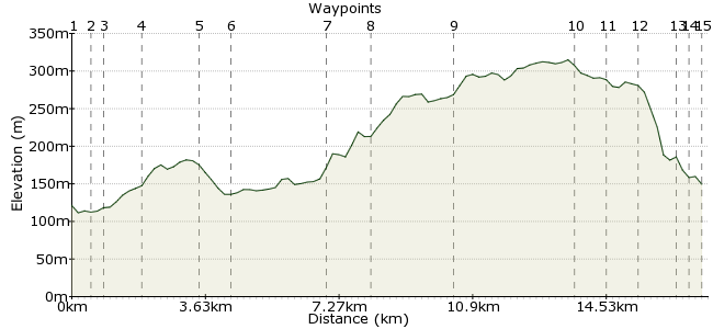
Ascent
237m (777ft)
Descent
208m (682ft)
Max. Elevation
320m (1049ft)
Altitude Gain & Loss
445m (1459ft)
Start
Gargrave Railway Station
End
Settle
Distance
17.30km
(10.75mi)
(10.75mi)
Duration
~5:45h
Difficulty
Moderate
Ordnance Survey Map
 2Created by mac.hawk on 13 Jan 2015
Gargrave to Settle along bridleways and quiet roads. Can be very puddley in the wet season.
580/581 buses service between Skipton-Gargrave-Settle & Kirkby Lonsdale. Train stations are on the Leeds-Carlisle/Morecambe lines. Route is about 11 1/5 miles but will walk longer in the wetter season as you dance around the puddles. Just sneaks into the YDNP a little after leaving Bell Busk.
Walk Functions
Share
Nearby Walks
Across the Yorkshire Dales
A hard, linear walk (low hills and fells (below 600m)) starting in North Yorkshire, England, about 63.10km (39.21 mi) long, duration: ~22:30h.Embsay Crag and Embsay Moor
A moderate, circular walk (low hills and fells (below 600m)) starting in North Yorkshire, England, about 10.80km (6.71 mi) long, duration: ~3:45h.Skipton Moor from Cracoe
A moderate, linear walk (low hills and fells (below 600m)) starting in North Yorkshire, England, about 15.00km (9.32 mi) long, duration: ~5:15h.Walk Map
- $walk->POI array(0)
Waypoints
OS Grid SD930536
Exit the railway station and turn left to pass St Andrews Church and cross the river to reach the road junction.
OS Grid SD931541
At the junction with the A65 carry on directly ahead up West Street to follow it to pass the Village Hall and cross the canal.
About 0.55 km (~0.34 miles) from 
OS Grid SD930544
Once over the canal follow the road as it passes Gargrave House and veers to the left then continue for half a mile before turning to track along Mark House Lane.
About 0.32 km (~0.2 miles) from 
OS Grid SD923551
Follow the bridleway to a little south of Haw Crag where it turns sharp left.
About 0.97 km (~0.6 miles) from 
OS Grid SD912562
Shortly after the sharp left the bridleway turns sharp right to cross the River Aire & Otterburn Beck to reach the road a little before Bell Busk.
About 1.60 km (~0.99 miles) from 
OS Grid SD904564
Follow the tarmac road through Bell Busk for a couple of miles to reach the bridge over Otterburn Beck (again) & cross and turn left. At the end of the housing on the right turn right up Dacre Lane.
About 0.78 km (~0.48 miles) from 
OS Grid SD881576
Follow Dacre lane uphill passing the woodland on the right to reach Hellifield Moor.
About 2.57 km (~1.6 miles) from 
OS Grid SD870583
Follow the track, still rising. Near Hellifield Moor Top reach two 5 bar gates. Go through the left hand one. From here to Bookilber Barn expect squish in wetter climes.
About 1.28 km (~0.8 miles) from 
OS Grid SD852595
Beyond Bookilber Barn the route thankfully turns to tarmac track and simply follow to reach the road junction near Scaleber Force.
About 2.19 km (~1.36 miles) from 
OS Grid SD841624
At the road junction turn left and detour briefly to visit the waterfall before continuing along the road to turn left into Lambert Lane.
About 3.15 km (~1.96 miles) from 
OS Grid SD834630
Follow the track, it eventually veers to the right and at the junction continue veering right into (the tarmac) Mitchell Lane and follow downhill.
About 0.86 km (~0.53 miles) from 
OS Grid SD828624
After about a mile Mitchell Lane meets the junction with Albert Hill. Turn left to pass Chapel House on your right.
About 0.82 km (~0.51 miles) from 
OS Grid SD823633
Follow the road downhill, take the cobbles to the left of Junction Lodge along Victoria Street to pass 'The Folly' (Museum of North Craven Life).
About 0.99 km (~0.62 miles) from 
OS Grid SD820635
After passing 'The Folly' turn left (or carry on ahead to reach the Market Square). Turn left again at the junction, pass the pelican crossing and turn right for 100 yards to the station access road.
About 0.38 km (~0.24 miles) from 
 Settle Railway Station
OS Grid SD816634
The access road leads to the railway station.
Walk is approx 11 1/2 miles but will walk longer in wet conditions as you dance around the puddles/mush.
About 0.39 km (~0.24 miles) from 
