Around Amberley
A moderate walk (countryside) in national park South Downs in West Sussex, England, about 14.90km (9.26 mi) long with an estimated walking time of about 4:45h. It is suitable for families with children, but unsuitable for prams & pushchairs, wheelchairs.
Elevation Profile
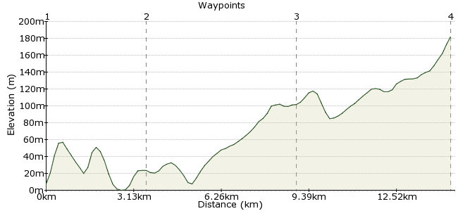
Ascent
175m (574ft)
Descent
166m (544ft)
Max. Elevation
190m (623ft)
Altitude Gain & Loss
341m (1118ft)
Start & End
Amberley
Distance
14.90km
(9.26mi)
(9.26mi)
Duration
~4:45h
Difficulty
Moderate
Ordnance Survey Map
Great scenery, enjoy a cup of tea in Arundel, and then on, up and over the hills. It's probably in the order of 4/5 hours. You could start from Amberley train station or Arundel and walk from there to Burpham.
Walk Functions
Share
Nearby Walks
The heart of the Downs
A strenuous, linear walk (countryside) starting in West Sussex, England, about 26.50km (16.47 mi) long, duration: ~9:00h.Amberley, Burpham and North Stoke
A moderate, circular walk (countryside) starting in West Sussex, England, about 11.70km (7.27 mi) long, duration: ~3:45h.Arundel pub walk
A leisurely, circular walk (riverside) starting in West Sussex, England, about 5.30km (3.29 mi) long, duration: ~1:45h.Walk Map
- $walk->POI array(0)
Waypoints
OS Grid TQ026118
Start at Amberley station. You can follow the route clockwise or anti-clockwise.
OS Grid TQ043086
Pretty village after walking either way to get here
About 3.64 km (~2.26 miles) from 
OS Grid TQ086119
Walk from the start either way to get here...what views!
About 5.43 km (~3.37 miles) from 
 Amberley again
OS Grid TQ029122
Finish back at the station.
About 5.65 km (~3.51 miles) from 

2 comments... join the discussion!
patrikG
Spot on, Patrick. Interestingly enough, the data we receive from our elevation service (we use Google's here) is inaccurate. Unfortunately, this is not something we can simply correct, but which Google would have to correct in their data so that it shows up correctly in the elevation graph.
Patrick Sullivan
For walk 1214 I think there is an error in the elevation graph. Waypoint 4 and 1 should be very close to the same elevation, and I am wondering if the graph indication of waypoint 4 is really waypoint 3 at 191 metres. Patrick