Otley Chevin & Caley Deer Park wander
A leisurely walk (countryside) in Leeds, England, about 7.20km (4.47 mi) long with an estimated walking time of about 2:45h. It is suitable for families with children, but unsuitable for prams & pushchairs, wheelchairs.
Elevation Profile
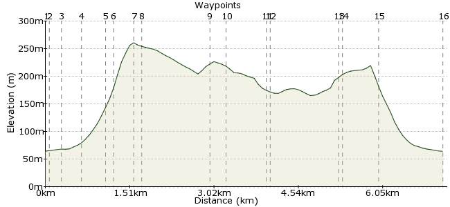
Ascent
266m (872ft)
Descent
266m (872ft)
Max. Elevation
270m (885ft)
Altitude Gain & Loss
532m (1744ft)
Start & End
Otley Bus Station
Distance
7.20km
(4.47mi)
(4.47mi)
Duration
~2:45h
Difficulty
Leisurely
Ordnance Survey Map
 2Created by mac.hawk on 01 Feb 2015
The Chevin & Deer Park have a multitude of tracks, this is simply one suggestion. Quite steep initial ascent might not suit everyone. The Otley Cross is raised each Easter at Surprise View.
Regular buses to Otley from Leeds, Bradford, Harrogate, York, Skipton, Ilkley and wherever in between.
Walk Functions
Share
Nearby Walks
On Ilkley Moor ...
A moderate, linear walk (moorland) starting in West Yorkshire, England, about 14.50km (9.01 mi) long, duration: ~5:00h.Golden Acre Park to Bramhope
A moderate, circular walk (countryside) starting in West Yorkshire, England, about 12.90km (8.02 mi) long, duration: ~4:00h.Ilkley Amble
A leisurely, circular walk (countryside) starting in Bradford, England, about 9.10km (5.65 mi) long, duration: ~2:45h.Walk Map
- $walk->POI array(0)
Waypoints
OS Grid SE202454
Leave the bus station and head up Crossgate heading towards the Chevin. Pass the memorial garden and turn right at the junction into Bondgate.
OS Grid SE203453
Head down Bondgate and at the junction immediately before the Parish Church turn left up Station Road.
About 0.10 km (~0.06 miles) from 
OS Grid SE201453
Follow Station Road to it's end and take the footbridge over the Otley Bypass.
About 0.11 km (~0.07 miles) from 
OS Grid SE202450
Once over the footbridge take a short snicket (ginnel) to then directly cross a road and follow another ginnel (wayposted Yorkgate) continuingly rising uphill.
About 0.35 km (~0.22 miles) from 
OS Grid SE203446
Reach another tarmac road and an entrance the Chevin Forest Park. Continue directly ahead up the obvious, cobbled (and a little stepped) route to eventually enter the woodland.
About 0.36 km (~0.22 miles) from 
OS Grid SE203445
Simply follow the stepped path directly uphill to reach a wide track.
About 0.14 km (~0.09 miles) from 
OS Grid SE203443
Carry on directly ahead up the hill to the summit plateau (or less directly; reach a couple of trees and veer left to more gently rise to the summit).
About 0.22 km (~0.14 miles) from 
OS Grid SE203441
From the rocky crags of Surprise View head east (i.e. as you've arrived at the summit plateau turn left) and follow the plateau path to East Chevin Road.
About 0.13 km (~0.08 miles) from 
OS Grid SE214443
Cross the road and take the track that turns right, uphill to reach the car park.
About 1.11 km (~0.69 miles) from 
OS Grid SE217442
At the car park turn left and follow the wayposted path on the left to follow the Ebor Way.
About 0.26 km (~0.16 miles) from 
OS Grid SE223444
Follow the wide track through the woodland to eventually reach an information board with a gate beyond. Go through the gate & a little way beyond turn sharp left downhill along a wayposted footpath.
About 0.68 km (~0.42 miles) from 
OS Grid SE223445
Follow the footpath downhill to reach a wide track and turn left and follow it as it rises uphill.
About 0.06 km (~0.04 miles) from 
OS Grid SE211445
Simply follow the forest track for a couple of miles to reach the East Chevin Road (again). Turn left up the road for 100 yards then turn right to cross the road into the East Chevin Car Park.
About 1.16 km (~0.72 miles) from 
OS Grid SE211444
Enter the car park and take the track beyond the wide metal gate to rise uphill. Follow without deviation to reach a T/Y junction.
About 0.08 km (~0.05 miles) from 
OS Grid SE205443
From the junction turn right and follow the track downhill to reach the base of the stepping to Surprise View. Retrace your steps downhill, back to Otley Bus Station.
About 0.60 km (~0.37 miles) from 
 Otley Bus Station
OS Grid SE203455
The route is approx 6 miles.
About 1.19 km (~0.74 miles) from 
