Snowdon from Pen-y-Pass to Llanberis
A moderate walk (mountain (above 600m)) in national park Snowdonia starting and finishing in Gwynedd, Wales, about 12.10km (7.52 mi) long with an estimated walking time of about 5:15h. It is unsuitable for families with children, prams & pushchairs, wheelchairs.
Elevation Profile
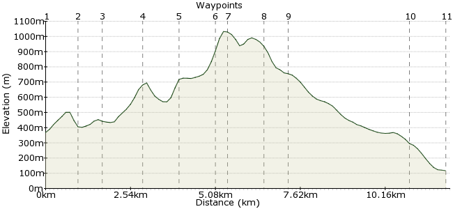
Ascent
660m (2165ft)
Descent
912m (2992ft)
Max. Elevation
1040m (3412ft)
Altitude Gain & Loss
1572m (5157ft)
Start
Pen-y-Pass
End
Llanberis
Distance
12.10km
(7.52mi)
(7.52mi)
Duration
~5:15h
Difficulty
Moderate
Ordnance Survey Map
There are many routes up Snowdon/Yr Wyddfa (more than the eight of popular opinion!) but one of the best is the high-level ridge of Y Lliwedd. This track leads you above the giant cliff faces that surround Llyn Llydaw and has far fewer people than Crib Goch across the chasm. Descend via the Llanberis Pass. It's easy which frees you up to admire the wonderful scenery.
Both start and finish are stops on the Snowdon Sherpa network: www.gwynedd.gov.uk/en/Residents/Parking-roads-and-travel/Travel-passes/Snowdon-Sherpa.aspx
Walk Functions
Share
Nearby Walks
The 'real' Snowdon horseshoe
A moderate, circular walk (mountain (above 600m)) starting in Gwynedd, Wales, about 10.20km (6.34 mi) long, duration: ~5:30h.Snowdon via Miners' Track
A moderate, linear walk (mountain (above 600m)) starting in Gwynedd, Wales, about 11.20km (6.96 mi) long, duration: ~5:15h.The Glyders in a day - east to west
A moderate, linear walk (mountain (above 600m)) starting in Gwynedd, Wales, about 14.60km (9.07 mi) long, duration: ~6:15h.Walk Map
- $walk->POI array(0)
Waypoints
OS Grid SH647555
Take the Snowdon Sherpa to the Pen-y-Pass youth hostel. If it's a weekend or sunny summer day, be grateful you are not trying to find a parking place at this overloaded car park.
OS Grid SH641548
Follow the Miners' Track past Llyn Teyrn.
About 0.91 km (~0.57 miles) from 
OS Grid SH634545
At the building, take the left-hand path off the Miners' Track, which starts to climb rapidly uphill south of Llyn Llydaw.
About 0.78 km (~0.48 miles) from 
OS Grid SH629534
The ridge follows the top of this vast wall, famous for being the site where early Everest expeditions practised their skills. Peer over the top for the full effect.
About 1.20 km (~0.75 miles) from 
OS Grid SH619536
Further along the ridge, the path meets the Watkin Path for a scramble up to the summit.
About 1.06 km (~0.66 miles) from 
OS Grid SH612541
The scramble can seem a little more precarious than you might like, but keep heading slowly upwards and you'll be out of it shortly.
About 0.91 km (~0.57 miles) from 
OS Grid SH609543
The top! Now with the newly refurbished summit cafe, an improvement on the old one. Well worth popping in for a cup of tea, and if you aren't a big fan of summit buildings, well be grateful we have very few of them, unlike our European cousins who whack them up all over the place.
About 0.34 km (~0.21 miles) from 
OS Grid SH607553
Drop down to Garnedd Ugain along a very clear path.
About 1.07 km (~0.66 miles) from 
OS Grid SH608560
It may not be everyone's favourite route, but for the full Snowdon experience descend via the Llanberis path to really appreciate how big the Snowdon massif is.
About 0.65 km (~0.4 miles) from 
OS Grid SH584587
At the penultimate station, veer towards the road into Llanberis.
About 3.63 km (~2.26 miles) from 
 Llanberis
OS Grid SH582597
Back to Llanberis, home of Pete's Eats, mountain shops galore, and the Snowdon Sherpa to explore more of the park.
About 1.05 km (~0.65 miles) from 
