Broadstone Warren in Ashdown Forest
A leisurely walk (woodland) in East Sussex, England, about 5.90km (3.67 mi) long with an estimated walking time of about 2:00h. It is unsuitable for families with children, prams & pushchairs, wheelchairs.
Elevation Profile
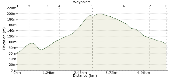
Ascent
139m (456ft)
Descent
108m (354ft)
Max. Elevation
200m (656ft)
Altitude Gain & Loss
247m (810ft)
Start & End
Forest Row
Distance
5.90km
(3.67mi)
(3.67mi)
Duration
~2:00h
Difficulty
Leisurely
Ordnance Survey Map
This short walk takes in a very enjoyable corner of Ashdown Forest. Starting from Forest Row, it's mostly in woodland - not always a given in Ashdown Forest - and makes a great half-day ramble.
Forest Row has good bus links from Crawley, East Grinstead and Tunbridge Wells.
Walk Functions
Share
Nearby Walks
Exploring Ashdown Forest
A moderate, linear walk (countryside) starting in East Sussex, England, about 15.70km (9.76 mi) long, duration: ~4:45h.Harrison's Rocks from Eridge
A moderate, circular walk (countryside) starting in Kent, England, about 15.10km (9.38 mi) long, duration: ~4:30h.A view of the Ouse Valley Viaduct
A leisurely, linear walk (countryside) starting in West Sussex, England, about 9.70km (6.03 mi) long, duration: ~2:45h.Walk Map
- $walk->POI array(0)
Waypoints
OS Grid TQ429348
Take the bus to Forest Row. Walk south along Chapel Lane.
OS Grid TQ428343
At the end of the lane, follow signs for the Vanguard Way (turn left/east).
About 0.48 km (~0.3 miles) from 
OS Grid TQ434339
Turn off the Vanguard Way onto a footpath that circuits the golf course. Watch out for flying balls!
About 0.69 km (~0.43 miles) from 
OS Grid TQ432336
The path enters the woodland shortly after the golf course. Follow the path south.
About 0.43 km (~0.27 miles) from 
OS Grid TQ431323
At the road, you turn right and there is a track heading northwest back through the woodlands.
About 1.30 km (~0.81 miles) from 
OS Grid TQ421328
This is a name that will resonate with anyone who was a Scout in the southeast. There's a large Scout camp here, so bring some marshmallows to toast just in case.
About 1.15 km (~0.71 miles) from 
OS Grid TQ424337
Follow the path north through Tompset's Bank, on the outskirts of Forest Row.
About 0.97 km (~0.6 miles) from 
 Forest Row again
OS Grid TQ428343
You rejoin Chapel Lane at the end of the path, so retrace your steps back to the bus stop.
About 0.69 km (~0.43 miles) from 
