Downs and Out
A leisurely walk (countryside) in national park South Downs starting and finishing in East Sussex, England, about 6.90km (4.29 mi) long with an estimated walking time of about 2:15h. It is unsuitable for families with children, prams & pushchairs, wheelchairs.
Elevation Profile
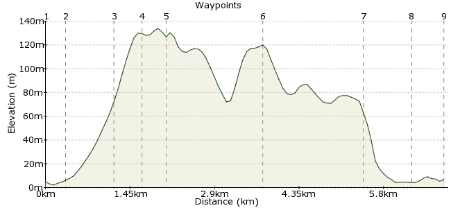
Ascent
128m (419ft)
Descent
126m (413ft)
Max. Elevation
140m (459ft)
Altitude Gain & Loss
254m (832ft)
Start
Glynde
End
Lewes
Distance
6.90km
(4.29mi)
(4.29mi)
Duration
~2:15h
Difficulty
Leisurely
Ordnance Survey Map
 Car Free Walks TeamCreated by GaryShipp on 10 Sep 2007
This walk is equally beautiful in either direction, basically being up one side of the hill and down the other. With breathtaking views across the South Downs and Sussex Weald, the River Ouse Valley and the lovely market town of Lewes, it will inspire anyone. Refreshments can be found at either end of the walk, with a tea rooms and pub in Glynde, and many opportunities to enjoy a pint of Harveys Ale in it's hometown of Lewes.
Walk Functions
Share
Nearby Walks
Ringmer - Saxon Cross - Lewes
A leisurely, linear walk (low hills and fells (below 600m)) starting in East Sussex, England, about 4.70km (2.92 mi) long, duration: ~1:30h.Two Hemispheres Walk
A moderate, linear walk (low hills and fells (below 600m)) starting in East Sussex, England, about 9.90km (6.15 mi) long, duration: ~3:15h.Arlington Reservoir and Village
A leisurely, circular walk (countryside) starting in East Sussex, England, about 5.60km (3.48 mi) long, duration: ~1:30h.Walk Map
- $walk->POI array(0)
Waypoints
OS Grid TQ456085
Start of the walk at the station
OS Grid TQ456089
Opposite the tea rooms is a stile.
About 0.40 km (~0.25 miles) from 
OS Grid TQ449091
Stop here at the well placed bench and take in the views.
About 0.72 km (~0.45 miles) from 
OS Grid TQ445092
Much of the had work is done but it's worth considering the detour southwards to visit the ancient fort of Mount Caburn.
About 0.45 km (~0.28 miles) from 
OS Grid TQ444088
A real bird's eye view of the Ouse Valley. When a southerly wind is in the air, a chance to watch the paragliders earn their wings.
About 0.40 km (~0.25 miles) from 
OS Grid TQ441104
Make sure you know where you are, as the wrong route choice here will send you downhill and off course.
About 1.63 km (~1.01 miles) from 
OS Grid TQ426099
Keep your eye out for the first sight of Lewes Castle.
About 1.63 km (~1.01 miles) from 
OS Grid TQ419102
If Real Ales are to your liking, then you can take a tour of this award-winning brewery. If time is precious, then just pop into the shop and buy a gift for a loved one!
About 0.76 km (~0.47 miles) from 
 Lewes Station
OS Grid TQ416098
On the Brighton, Eastbourne, Hastings and London lines.
About 0.58 km (~0.36 miles) from 

1 comment... join the discussion!
Timwoods
Big thank you to everyone who did 'Downs and Out' on the Car Free Walks launch party. Beautiful weather + lots of friends = a great start to Car Free Walks! Hopefully more walks will follow soon, watch this space...!