A view over Ladybower
A moderate walk (low hills and fells (below 600m)) in national park Peak District in Derbyshire, England, about 14.00km (8.70 mi) long with an estimated walking time of about 5:00h. It is unsuitable for families with children, prams & pushchairs, wheelchairs.
Elevation Profile
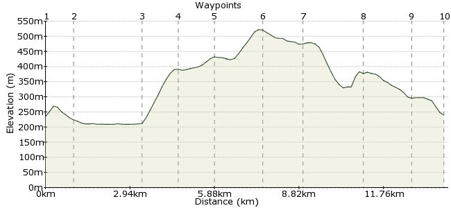
Ascent
306m (1003ft)
Descent
301m (987ft)
Max. Elevation
530m (1738ft)
Altitude Gain & Loss
607m (1990ft)
Start & End
Ladybower Inn
Distance
14.00km
(8.7mi)
(8.7mi)
Duration
~5:00h
Difficulty
Moderate
Ordnance Survey Map
Right in the heart of the Peak District, Ladybower Reservoir is a well-known beauty spot. This walk combines a waterside walk with a hike over Derwent Edge, one of the great ridges in this part of the world.
There are good bus links to the Ladybower Inn from Sheffield, on the route serving Bakewell and Bamford.
Walk Functions
Share
Nearby Walks
Across the Divide - Hope to Edale
A leisurely, linear walk (low hills and fells (below 600m)) starting in Derbyshire, England, about 8.60km (5.34 mi) long, duration: ~3:15h.Ladybower, Win Hill & Hope
A leisurely, linear walk (low hills and fells (below 600m)) starting in Derbyshire, England, about 9.00km (5.59 mi) long, duration: ~3:15h.The Hope Valley Skyline Walk southern half
A moderate, linear walk (low hills and fells (below 600m)) starting in Derbyshire, England, about 16.70km (10.38 mi) long, duration: ~6:15h.Walk Map
- $walk->POI array(0)
Waypoints
OS Grid SK203864
Take the bus to the Ladybower Inn.
OS Grid SK194864
Follow the path westwards towards the shore of the reservoir and then follow it north.
About 0.92 km (~0.57 miles) from 
OS Grid SK184887
Follow the track as far as the road. Follow for a few metres then take the steep path heading uphill on the right.
About 2.43 km (~1.51 miles) from 
OS Grid SK181898
Great views back along the reservoir from the top.
About 1.16 km (~0.72 miles) from 
OS Grid SK181910
Follow the path uphill and then veer east with the path.
About 1.21 km (~0.75 miles) from 
OS Grid SK197909
Head for the summit of Back Tor, then follow the ridge due south.
About 1.59 km (~0.99 miles) from 
OS Grid SK196895
One of the great Peaks' walks, this: classic views from Derwent Edge.
About 1.35 km (~0.84 miles) from 
OS Grid SK197874
At Whinstone Lee Tor, head east towards the road.
About 2.18 km (~1.35 miles) from 
 Highshaw Clough
OS Grid SK213874
At Highshaw Clough, double back and follow the roadsie path to the pub once more.
About 1.54 km (~0.96 miles) from 
 Ladybower Inn again