Rhuddlan Castle and Dyserth Falls.
A leisurely walk (countryside) in Denbighshire, Wales, about 8.90km (5.53 mi) long with an estimated walking time of about 2:30h. It is suitable for families with children, but unsuitable for prams & pushchairs, wheelchairs.
Elevation Profile
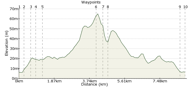
Ascent
56m (183ft)
Descent
56m (183ft)
Max. Elevation
70m (229ft)
Altitude Gain & Loss
112m (366ft)
Start & End
Rhuddlan
Distance
8.90km
(5.53mi)
(5.53mi)
Duration
~2:30h
Difficulty
Leisurely
Ordnance Survey Map

Walk Functions
Share
Nearby Walks
Rhyl-Rhuddlan-Rhyl
A leisurely, circular walk (riverside) starting in Clwyd, Wales, about 9.20km (5.72 mi) long, duration: ~2:30h.Prestatyn Hillside
A leisurely, circular walk (low hills and fells (below 600m)) starting in Denbighshire, Wales, about 8.10km (5.03 mi) long, duration: ~2:45h.Abergele - Tower Hill
A leisurely, circular walk (countryside) starting in Clwyd, Wales, about 5.00km (3.11 mi) long, duration: ~1:45h.Walk Map
- $walk->POI array(0)
Waypoints
OS Grid SJ019778
Served by Arriva Buses No. 13 to / from Prestatyn / Llandudno,
Buses to / from Dyserth No. 35, or for a longer walk see Pathfinder Guides No. 32, Walk No. 4, Rhyl and Rhuddlan.
OS Grid SJ021780
After crossing pedestrian bridge over river, walk uphill, cross to first road on right, Castle Street and follow to Castle entrance.
About 0.28 km (~0.17 miles) from 
OS Grid SJ024779
After seeing Castle, maybe paying entrance fee £3.40 to go in to view, you may like to go and see Twthill, exit car park, turn right, first right, look up into hedge to see overgrown blue sign.
About 0.31 km (~0.19 miles) from 
OS Grid SJ026779
Junction with Princes Road, turn right, at crossroads straight ahead into Dyserth Road.
About 0.20 km (~0.12 miles) from 
OS Grid SJ030780
Turn right and follow quiet, wide footpath / cycle track up to Dyserth village.
About 0.40 km (~0.25 miles) from 
OS Grid SJ056789
See sign for waterfall, cross and turn left downhill, CARE NEEDED, no footpath on some short stretches to see sign for Waterfall, cross and enter by Waterfall Shop, HONESTY BOX at rear , 40p EACH.
About 2.72 km (~1.69 miles) from 
OS Grid SJ056793
There are 2 waterfalls, see 2nd. after crossing small bridge, if able take steps to left, uphill path to top, 3 benches on way to rest if needed for panoramic views of area.
About 0.40 km (~0.25 miles) from 
OS Grid SJ055794
Retrace way up back into Rhuddlan.
About 0.21 km (~0.13 miles) from 
OS Grid SJ020780
Before crossing you could turn right beneath Church and follow NORTH WALES PATH which would take you into Rhyl by the Marine Lake, if not, cross to opposite bus stop to one you alighted at earlier.
About 3.74 km (~2.32 miles) from 
 End of walk
OS Grid SJ020777
Hope you enjoyed and will tell friends / others.
About 0.28 km (~0.17 miles) from 
