High Street from Patterdale
A moderate walk (mountain (above 600m)) in national park Lake District in Cumbria, England, about 15.50km (9.63 mi) long with an estimated walking time of about 6:30h. It is unsuitable for families with children, prams & pushchairs, wheelchairs.
Elevation Profile
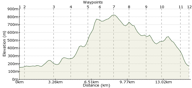
Ascent
671m (2201ft)
Descent
656m (2152ft)
Max. Elevation
830m (2723ft)
Altitude Gain & Loss
1327m (4353ft)
Start & End
Patterdale
Distance
15.50km
(9.63mi)
(9.63mi)
Duration
~6:30h
Difficulty
Moderate
Ordnance Survey Map
This long Lake District walk is a challenge but one within the reaches of most walkers. Starting at Patterdale, the route follows the river and then heads into a little-visited valley. A steep climb takes you onto the high ground around High Street, and it's then a superb walk along the upper ground back to Patterdale. A long but rewarding day out. There is a YHA in Patterdale for longer stays.
Walk Functions
Share
Nearby Walks
Place Fell from Patterdale
A moderate, circular walk (mountain (above 600m)) starting in Cumbria, England, about 9.80km (6.09 mi) long, duration: ~4:15h.YHA Patterdale to YHA Grasmere
A moderate, linear walk (mountain (above 600m)) starting in Cumbria, England, about 12.20km (7.58 mi) long, duration: ~5:30h.Grisedale low-level walk
A leisurely, circular walk (low hills and fells (below 600m)) starting in Cumbria, England, about 7.20km (4.47 mi) long, duration: ~2:15h.Walk Map
- $walk->POI array(0)
Waypoints
OS Grid NY398159
Start the walk at Patterdale. There are buses year-round from Penrith and in summer a bus connects Penrith to Bowness as well.
OS Grid NY401155
Cross the river and pick up the footpath along the valley bottom.
About 0.51 km (~0.32 miles) from 
OS Grid NY410131
Continue to Hartsop where you head into the hills. There is a bus stop at Brotherswater for a slightly shorter walk in (but check times as it's less frequent than buses to Patterdale).
About 2.57 km (~1.6 miles) from 
OS Grid NY419118
Follow the path into Pasture Beck.
About 1.58 km (~0.98 miles) from 
OS Grid NY424104
It's a steep climb up the valley head to Threshthwaite Beacon.
About 1.47 km (~0.91 miles) from 
OS Grid NY433099
Continue along the high ground to Thornthwaite Crag.
About 1.00 km (~0.62 miles) from 
OS Grid NY440110
Continue north along the high ground to High Street.
About 1.27 km (~0.79 miles) from 
OS Grid NY438123
Follow the ridge north, with fine views over Hayeswater.
About 1.37 km (~0.85 miles) from 
OS Grid NY428134
A path circuits the upper flanks of Rest Dodd.
About 1.44 km (~0.89 miles) from 
OS Grid NY418144
Continue via Angle Tarn back towards Patterdale.
About 1.47 km (~0.91 miles) from 
OS Grid NY406156
At Boredale Hause you are nearly home again.
About 1.65 km (~1.03 miles) from 
 Rooking
OS Grid NY400160
Drop down into Rooking, across the river from Patterdale.
About 0.74 km (~0.46 miles) from 
