Coniston to Elterwater via Little Langdale
A leisurely walk (low hills and fells (below 600m)) in national park Lake District starting and finishing in Cumbria, England, about 9.40km (5.84 mi) long with an estimated walking time of about 3:30h. It is unsuitable for families with children, prams & pushchairs, wheelchairs.
Elevation Profile
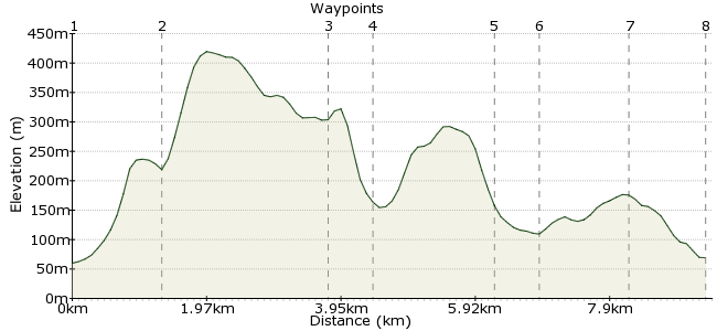
Ascent
311m (1020ft)
Descent
302m (990ft)
Max. Elevation
420m (1377ft)
Altitude Gain & Loss
613m (2010ft)
Start
Coniston Village Centre
End
Elterwater Post Office
Distance
9.40km
(5.84mi)
(5.84mi)
Duration
~3:30h
Difficulty
Leisurely
 Car Free Walks TeamCreated by GaryShipp on 12 Sep 2007
A beautiful walk in the lower fells, often quieter than the main summits, and great for those days when the hills are covered.
Walk Functions
Share
Nearby Walks
Wetherlam
A moderate, linear walk (mountain (above 600m)) starting in Cumbria, England, about 11.30km (7.02 mi) long, duration: ~5:15h.An Old Man's stroll from Coniston
A moderate, circular walk (mountain (above 600m)) starting in Cumbria, England, about 10.60km (6.59 mi) long, duration: ~5:00h.A circular walk around Hawkshead
A moderate, circular walk (woodland) starting in Cumbria, England, about 12.60km (7.83 mi) long, duration: ~4:15h.Walk Map
- $walk->POI array(0)
Waypoints
OS Grid SD302975
Start of the walk
OS Grid SD293984
Follow side of Levers Water Beck towards Youth Hostel. Taking path junction northwards
About 1.31 km (~0.81 miles) from 
OS Grid NY299007
Join this stream and follow the side of its impressive gully.
About 2.35 km (~1.46 miles) from 
OS Grid NY306010
Head northwards with stunning scenery all around
About 0.70 km (~0.43 miles) from 
OS Grid NY306027
Head east here past the climbing club hut at Low Hall Garth
About 1.75 km (~1.09 miles) from 
OS Grid NY312029
Cross the ancient bridge downstream of Little Langdale Tarn.
About 0.57 km (~0.35 miles) from 
OS Grid NY319039
This route presents a lovely approach to Elterwater through some typical lakes woodland.
About 1.24 km (~0.77 miles) from 
 Elterwater Post Office
OS Grid NY328048
Cathc the bus here, with the pub nearby a great place to while away the time.
About 1.19 km (~0.74 miles) from 
