A walk of two halves
A moderate walk (countryside) starting and finishing in East Sussex, England, about 18.60km (11.56 mi) long with an estimated walking time of about 6:00h. It is unsuitable for families with children, prams & pushchairs, wheelchairs.
Elevation Profile
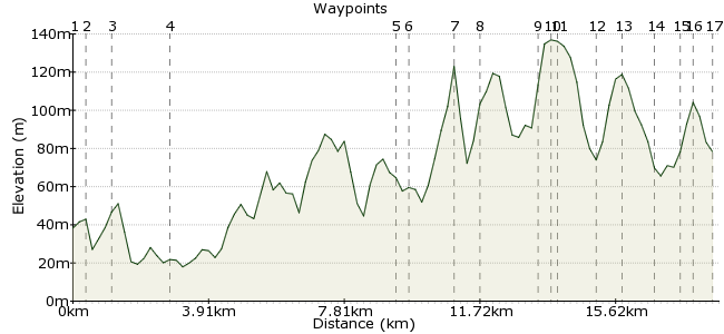
Ascent
215m (705ft)
Descent
173m (567ft)
Max. Elevation
140m (459ft)
Altitude Gain & Loss
388m (1272ft)
Start
Newick
End
Balcombe
Distance
18.60km
(11.56mi)
(11.56mi)
Duration
~6:00h
Difficulty
Moderate
Ordnance Survey Map
 Car Free Walks TeamCreated by GaryShipp on 10 Aug 2015
A bit of a twist in that the walk is split with a train ride on the lovely Bluebell Railway. This not only allows you the chance for a rest, but the stations offer the chance for some refreshment as well.
Walk Functions
Share
Nearby Walks
Ringmer - Saxon Cross - Lewes
A leisurely, linear walk (low hills and fells (below 600m)) starting in East Sussex, England, about 4.70km (2.92 mi) long, duration: ~1:30h.Windmills and a war memorial in the Downs
A leisurely, linear walk (low hills and fells (below 600m)) starting in East Sussex, England, about 6.20km (3.85 mi) long, duration: ~2:00h.South Downs Way: Housedean Farm to Pyecombe
A moderate, linear walk (low hills and fells (below 600m)) starting in East Sussex, England, about 11.10km (6.90 mi) long, duration: ~3:30h.Walk Map
- $walk->POI array(0)
Waypoints
OS Grid TQ417213
Start at the Bus Stop - service 121 from Lewes
OS Grid TQ414217
Take care on the road section
About 0.48 km (~0.3 miles) from 
OS Grid TQ409223
Follow the sign that appears to be pointing up somebodies driveway
About 0.77 km (~0.48 miles) from 
OS Grid TQ402237
The Bluebell Railway has restored this station in the style of the Brighton era in the 1880s. Refreshments are available as well as a well-stocked gift shop.
About 1.57 km (~0.98 miles) from 
OS Grid TQ370292
The Bluebell Railway has restored the station to the Southern Railway period – mid 1920s. The station is often featured in films and television, most recently as "Downton†in the popular Downton Abbey
About 6.42 km (~3.99 miles) from 
OS Grid TQ372296
A good vantage point for catching views of the trains arriving and leaving the station
About 0.40 km (~0.25 miles) from 
OS Grid TQ361301
A fascinating architectural oddity believed to date from around 1780. It sits next to All Saints Church famed for its Carillon which chimes the bells daily at Noon, 3pm and 6pm.
About 1.20 km (~0.75 miles) from 
OS Grid TQ353305
Pickup the route of this 95 mile long distance trail - details at http://www.highweald.org/explore-sussex/walking/625-high-weald-landscape-trail.html
About 0.86 km (~0.53 miles) from 
OS Grid TQ343316
A delightful path follows the valley with some interesting formations of sandstone rock elevated in the undergrowth to your left
About 1.43 km (~0.89 miles) from 
OS Grid TQ343319
This is quite a busy rural rat run so take care when crossing and follow the verge back south to Wakehurst Place
About 0.37 km (~0.23 miles) from 
OS Grid TQ341317
A National Trust property combined with Royal Botanical Gardens make this a visitor hotbed. Pay your entry or obey the many signs requesting you resist temptation to deviate from the right of way
About 0.30 km (~0.19 miles) from 
OS Grid TQ331316
A lovely little spot for a rest by this babbling brook
About 0.98 km (~0.61 miles) from 
OS Grid TQ324315
Check your map here as the path is less obvious and not very well sign posted
About 0.71 km (~0.44 miles) from 
OS Grid TQ316309
A good spot for fishing (private) or stone skimming (presumably not . . )
About 0.97 km (~0.6 miles) from 
OS Grid TQ310310
A fine stately pile whose upkeep alone would bankrupt most of us
About 0.67 km (~0.42 miles) from 
OS Grid TQ309307
Check the opening times before you rely on this pub for any refreshment at the end of the walk as it was closed when I was there. Thankfully the village club opposite was happy to accept me as a guest
About 0.32 km (~0.2 miles) from 
 Balcombe Station
OS Grid TQ306302
Served by hourly trains in each direction during the day and a bit more fequency to get the commuters in and out either side. Change at Haywards Heath or Gatwick Airport for more choice of destination
About 0.53 km (~0.33 miles) from 
