Ashbourne to Buxton
A hard walk (low hills and fells (below 600m)) in national park Peak District starting and finishing in Derbyshire, England, about 40.40km (25.10 mi) long with an estimated walking time of about 13:15h (1 overnight stay). It is unsuitable for families with children, prams & pushchairs, wheelchairs.
Elevation Profile
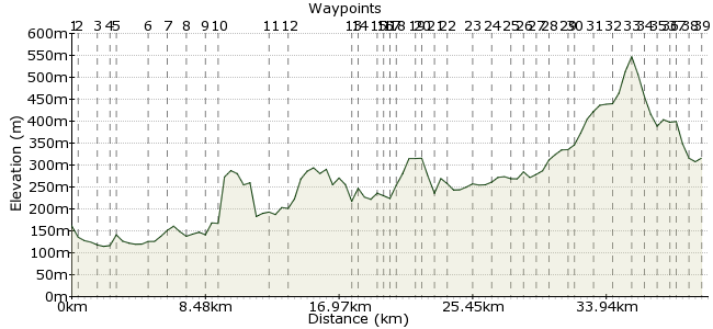
Ascent
558m (1830ft)
Descent
403m (1322ft)
Max. Elevation
550m (1804ft)
Altitude Gain & Loss
961m (3152ft)
Start
Ashbourne
End
Buxton
Distance
40.40km
(25.1mi)
(25.1mi)
Duration
~13:15h
Difficulty
Hard
Ordnance Survey Maps
40km of walking to take you all the way through the best bits of Dovedale in the South Peak District NP.
Walk Functions
Share
Nearby Walks
Allsop Moor to Earl Sterndale via Hartington
A moderate, linear walk (countryside) starting in Derbyshire, England, about 16.30km (10.13 mi) long, duration: ~5:15h.Along the Manifold Way
A moderate, linear walk (riverside) starting in Staffordshire, England, about 12.90km (8.02 mi) long, duration: ~4:00h.Derbyshire delights in Dovedale
A moderate, linear walk (riverside) starting in Derbyshire, England, about 14.90km (9.26 mi) long, duration: ~4:30h.Walk Map
- $walk->POI array(0)
Waypoints
OS Grid SK178470
Take the bus to Ashbourne to start the walk and fuel yourself for the route ahead.
OS Grid SK175468
Find the lane to exit Ashbourne to the north, and follow the footpaths across the watermeadows overlooking the Dove valley
About 0.35 km (~0.22 miles) from 
OS Grid SK163463
Walk quickly to the north of the sewage farm to get to the river and the main bridge
About 1.35 km (~0.84 miles) from 
OS Grid SK159457
First chance to see the Dove and the wonderful old bridge to cross over it.
About 0.70 km (~0.43 miles) from 
OS Grid SK157460
Wander into the parkland via this back road taking you to the west of the Dove
About 0.35 km (~0.22 miles) from 
OS Grid SK160482
Find the old water mill (listen out for the water rushing) and wander the paths through the fields northwards
About 2.18 km (~1.35 miles) from 
OS Grid SK157492
drop down to the river and through the woods easy nav through the footpaths fields
About 1.12 km (~0.7 miles) from 
OS Grid SK148497
Cross the Dove on this ancient bridge to get east of the river
About 1.09 km (~0.68 miles) from 
OS Grid SK147510
This is wher most walkers see the river from. It gets busy through here at times...
About 1.26 km (~0.78 miles) from 
OS Grid SK151514
Walk the east banks through amazing gorge scenery. Just follow the paths and look up down, left and right to enjoy the rocks, the trees, the river and the caves!
About 0.54 km (~0.34 miles) from 
OS Grid SK138546
Great little back of beyond café - serviing much needed teas and coffees and sarnies etc from the front room for take away only. Welcome to MillDale
About 3.53 km (~2.19 miles) from 
OS Grid SK145551
Use the minor road to find the bridge and cross again
About 0.84 km (~0.52 miles) from 
OS Grid SK127586
Cross the Dove for a few hundred metres
About 3.99 km (~2.48 miles) from 
OS Grid SK128589
Walk the paths to the obvious Hartington town,
About 0.24 km (~0.15 miles) from 
OS Grid SK126603
As you come into the services of the town, the Charles Cooke hotel is obvious for food and drinks but there are others and shops and post offices and gifts
About 1.41 km (~0.88 miles) from 
OS Grid SK125604
Head across the fields to the river once more
About 0.23 km (~0.14 miles) from 
OS Grid SK120609
Keep right, and turn to avoid the hilltop climb
About 0.70 km (~0.43 miles) from 
OS Grid SK120612
Now you're on top, enjoy the views back over the ground you've walked and keep going north!
About 0.27 km (~0.17 miles) from 
OS Grid SK116622
Tight squeeze alongside an old barn, but turn R on road and walk a hundred metresish
About 1.06 km (~0.66 miles) from 
OS Grid SK115624
Dropping to Pilsbury next, there is a feeling of walking back through the ages, cross the ford if you like, or use the bridge depending on your need for cooling the feet.
About 0.30 km (~0.19 miles) from 
OS Grid SK117634
head north through the farm buildings and tree cover
About 0.94 km (~0.58 miles) from 
OS Grid SK114638
take the footpath through the gate to the motte and bailey castle grounds and the cool tree and rock formations,
About 0.52 km (~0.32 miles) from 
OS Grid SK100651
Great food and drink options and there's a campsite down by the farm you'll have just walked through by the river.
About 1.88 km (~1.17 miles) from 
OS Grid SK095659
The hills here are stunning, and you could well wish you were on top. If that's the case, make the efforts.
About 0.96 km (~0.6 miles) from 
OS Grid SK083666
there's the british caving library. Cross the road and up the lane
About 1.33 km (~0.83 miles) from 
OS Grid SK077668
It's stunning around here isn't it? If you've not been, get walking!
About 0.69 km (~0.43 miles) from 
OS Grid SK068666
Through the farms and the village and up the hill
About 0.94 km (~0.58 miles) from 
OS Grid SK062667
It gets a bit confusing here, but not bad enough to complain, just keep the river on the right enjoy the views and duck when the Rowan trees encroach
About 0.53 km (~0.33 miles) from 
OS Grid SK051673
Paths deteriorate, but keep on the hill until you round the head and drop to the river with the very old bridge.
About 1.27 km (~0.79 miles) from 
OS Grid SK050676
It's difficult to find the path, but there is one, and even with Bracken high, keep the river on your left and head up the steep banks to get onto the field edges
About 0.32 km (~0.2 miles) from 
OS Grid SK044684
Old farms high ground and much more moorland
About 0.97 km (~0.6 miles) from 
OS Grid SK038694
Cross the bog, carefully. It's got some deep holes if very wet!
About 1.23 km (~0.76 miles) from 
OS Grid SK034705
Find your own way up here, there's no official path, so just bash up and get the proper views you deserve if youve got here. '
About 1.16 km (~0.72 miles) from 
OS Grid SK036714
You've seen the end of the Dove, but you can also see Buxton, the end of your walk!
About 0.91 km (~0.57 miles) from 
OS Grid SK042718
Find the unsigned gateway to get off the road to the country park entrance
About 0.70 km (~0.43 miles) from 
OS Grid SK045721
Buxton Country Park used to be a quarry. Walk into the car park not the caravan park and get ready to rejoin civilisation.
About 0.46 km (~0.29 miles) from 
OS Grid SK050719
Drop through the woods to the town
About 0.50 km (~0.31 miles) from 
OS Grid SK049726
Wander the streets towards town centre
About 0.64 km (~0.4 miles) from 
 Bus stop
OS Grid SK058732
catch the bus back to ashbourne after that well earned cake. Also, you might need new boots so there's plenty of shopping available. Buses run regularly and take you back past all the brilliant sights
About 1.12 km (~0.7 miles) from 

1 comment... join the discussion!
CharlieCheeze
I just walked this route this last weekend. It was brilliant and the bus connections superb. Eating and drinking options plentiful and the scenery is stunning. Highly recommended!