Nant-y-Glyn Valley
A leisurely walk (countryside) in Clwyd, Wales, about 8.40km (5.22 mi) long with an estimated walking time of about 3:00h. It is suitable for families with children, but unsuitable for prams & pushchairs, wheelchairs.
Elevation Profile
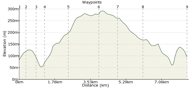
Ascent
253m (830ft)
Descent
242m (793ft)
Max. Elevation
300m (984ft)
Altitude Gain & Loss
495m (1623ft)
Start & End
Colwyn Bay
Distance
8.40km
(5.22mi)
(5.22mi)
Duration
~3:00h
Difficulty
Leisurely
Ordnance Survey Map
 1Created by driver 16 on 12 Oct 2015
A walk through woods, fields, meadows by and across small streams, many blackberry bushes (blackberry mountain) views from highest point of Little / Great Ormes, Deganwy, Conway / Penmaenmawr / Carneddau Mountains, Puffin Island and Anglesey on clear days, because of nature of walk, some areas will be very wet after any heavy rain.
Walk Functions
Share
Nearby Walks
Xmas Day circular from Colwyn Bay
A moderate, circular walk (countryside) starting in Clwyd, Wales, about 15.20km (9.44 mi) long, duration: ~4:30h.Circular E, S. and W. from C/Bay.
A moderate, circular walk (coast) starting in Clwyd, Wales, about 14.00km (8.70 mi) long, duration: ~4:15h.Colwyn Bay, Llanddulas, Llysfaen circular
A moderate, circular walk (countryside) starting in Clwyd, Wales, about 14.00km (8.70 mi) long, duration: ~4:30h.Walk Map
- $walk->POI array(0)
Waypoints
OS Grid SH848784
Cross Old Highway into unadopted road - Pen-y-Bryn, walk up to near first bend to see footpath sign on left through kissing gate.
OS Grid SH850781
Follow footpath bearing right at first bend to meet private drive at bottom.
About 0.35 km (~0.22 miles) from 
OS Grid SH848777
Turn left and in short distance take path on right down to cross meadow and bridge.
About 0.45 km (~0.28 miles) from 
OS Grid SH852778
After crossing bear left to see steps set in side of hill, climb up, at top turn right, follow path through trees to 3 branch sign and stile.
About 0.35 km (~0.22 miles) from 
OS Grid SH848767
Climb over, cross field uphill to see next waypoint on side of cut down tree, through kissing gate, at lane straight across, keep fence on right, cross 2 small bridges through woods.
About 1.10 km (~0.68 miles) from 
OS Grid SH844753
Turn left through gate, see outbuilding on left, go right across fields, stiles to highest point on walk.
About 1.47 km (~0.91 miles) from 
OS Grid SH852754
Downhill from here following side of fields.
About 0.83 km (~0.52 miles) from 
OS Grid SH858765
Follow behind ruined outbuildings down to wide grassy meadow, through kissing gate at bottom on path which meets steps from waypoint 4 earlier, just retrace route from outward earlier.
About 1.25 km (~0.78 miles) from 
 End of walk
OS Grid SH847783
Hope you enjoyed and will recommend to friends.
About 2.13 km (~1.32 miles) from 
