The outer reaches of Swaledale
A moderate walk (countryside) in national park Yorkshire Dales starting and finishing in North Yorkshire, England, about 15.60km (9.69 mi) long with an estimated walking time of about 5:00h. It is suitable for families with children, but unsuitable for prams & pushchairs, wheelchairs.
Elevation Profile
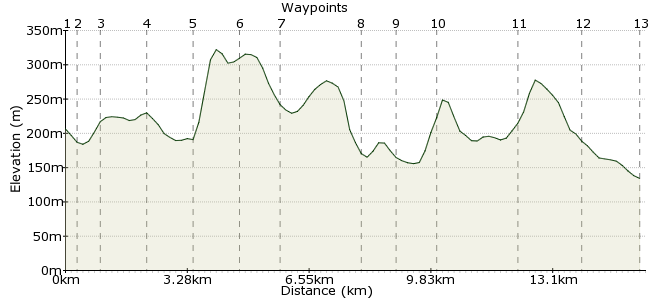
Ascent
205m (672ft)
Descent
277m (908ft)
Max. Elevation
330m (1082ft)
Altitude Gain & Loss
482m (1580ft)
Start
Reeth
End
Richmond
Distance
15.60km
(9.69mi)
(9.69mi)
Duration
~5:00h
Difficulty
Moderate
If I had to pick a favourite dale, it would probably be Swaledale. It's a wonderful place for walking right along its length, and while many will want to head deep into it, this route along its outer reaches is one of its best. The route can be done in either direction, but bus connections are better from Richmond than Reeth, so heading outwards makes some sense.
Walk Functions
Share
Nearby Walks
Fremington Edge and Arkengarthdale
A moderate, circular walk (low hills and fells (below 600m)) starting in North Yorkshire, England, about 13.30km (8.26 mi) long, duration: ~4:30h.Exploring the mines around Grinton
A leisurely, circular walk (low hills and fells (below 600m)) starting in North Yorkshire, England, about 8.30km (5.16 mi) long, duration: ~3:15h.Apedale from Aysgarth
A moderate, circular walk (low hills and fells (below 600m)) starting in North Yorkshire, England, about 19.70km (12.24 mi) long, duration: ~6:45h.Walk Map
- $walk->POI array(0)
Waypoints
OS Grid SE038993
Take the bus to Reeth in Swaledale. If you want an overnight stay/early start, then the youth hostel at nearby Grinton makes for a great stopover.
OS Grid SE041991
Head south from the village centre, and head for the bridge.
About 0.38 km (~0.24 miles) from 
OS Grid SE047991
Pick up the low-level footpath that circuits along Fremington Edge and through its namesake village.
About 0.60 km (~0.37 miles) from 
OS Grid SE057987
When you meet the road, go straight and look for the path on the right-hand side. Once on it, take the first junction left.
About 1.12 km (~0.7 miles) from 
OS Grid SE067978
Follow the path down to Marrick Priory, now partly ruined and partly outdoor centre.
About 1.30 km (~0.81 miles) from 
OS Grid SE077982
From the road by the priory, take the path heading across fields and farms into Marrick.
About 1.12 km (~0.7 miles) from 
OS Grid SE086991
From Marrick, a long, cross-country path takes you downhill towards Marske.
About 1.20 km (~0.75 miles) from 
OS Grid NZ103004
Take care on the short road section into the village.
About 2.16 km (~1.34 miles) from 
OS Grid NZ109009
Upon leaving Marske via the main route through the village, look for a footpath on your right.
About 0.75 km (~0.47 miles) from 
OS Grid NZ117015
The path leads out onto a track above the River Swale and the outer reaches of Swaledale.
About 1.04 km (~0.65 miles) from 
OS Grid NZ139018
A fine section of walking to end, as you meander beneath Whitcliffe Scar and through Whitcliffe Wood.
About 2.20 km (~1.37 miles) from 
OS Grid NZ155015
The path takes you right into Richmond, a welcoming town on the edge of the Dales.
About 1.65 km (~1.03 miles) from 
 Town centre
OS Grid NZ171010
Head for the town centre for buses. There are connections to Northallerton and Darlington for train services.
About 1.67 km (~1.04 miles) from 

1 comment... join the discussion!
Timwoods
This is a great walk. I have done a similar one myself, taken from a book called 'Green Networks of the Dales' by Colin Speakman. Well worth tracking down a copy if you love walking in this part of the world. www.abebooks.co.uk/book-search/title/green-networks-of-the-dales/author/colin-speakman/