Colton to Aberford (suburban Leeds)
A leisurely walk (countryside) starting and finishing in Leeds, England, about 8.40km (5.22 mi) long with an estimated walking time of about 2:15h. It is suitable for families with children, but unsuitable for prams & pushchairs, wheelchairs.
Elevation Profile
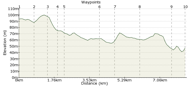
Ascent
14m (45ft)
Descent
61m (200ft)
Max. Elevation
100m (328ft)
Altitude Gain & Loss
75m (245ft)
Start
Colton Retail Park, Leeds
End
Aberford
Distance
8.40km
(5.22mi)
(5.22mi)
Duration
~2:15h
Difficulty
Leisurely
Ordnance Survey Map
 2Created by mac.hawk on 28 Nov 2015
A bridleway walk on the NE side of Leeds. Regular buses to/from Colton & Aberford from Leeds.
Nice, relatively flat walk along obvious wide tracks.
Aberford is well worth a wander as it has some very interesting architecture & St Ricarius Church is worth a visit.
Pub & village store just beyond the bridge over Cod Beck near the return bus stop.
Walk Functions
Share
Nearby Walks
Colton to Scholes via Barwick
A leisurely, linear walk (countryside) starting in Leeds, England, about 8.90km (5.53 mi) long, duration: ~2:30h.Roundhay Park Ramble
A leisurely, circular walk (city/town) starting in Leeds, England, about 4.40km (2.73 mi) long, duration: ~1:15h.Retail therapy?
A leisurely, circular walk (woodland) starting in Leeds, England, about 7.10km (4.41 mi) long, duration: ~2:00h.Walk Map
- $walk->POI array(0)
Waypoints
OS Grid SE374333
Alight the bus at Colton Retail Park (Sainsbury's) and head for Thorpe Park Business Park. Take the road down Century Way to reach a roundabout.
OS Grid SE380337
At the roundabout take the bridleway that heads right then climbs uphill a little. Follow the track as it runs alongside the motorway on the right briefly.
About 0.78 km (~0.48 miles) from 
OS Grid SE386339
At the footbridge over the motorway turn left into a fenced track that leads downhill to Shippen House Farm.
About 0.68 km (~0.42 miles) from 
OS Grid SE387344
Immediately in front of the Shippen House Farm turn left for 100 yards before turning right taking the wide track (Leeds Country Way) for 1/3 mile to reach a track on the right.
About 0.44 km (~0.27 miles) from 
OS Grid SE387346
Unfortunately the RoW bridleway is currently not wayposted, but follow the obvious track as it soon passes through Garforth Golf Course and Willow Park Farm on the right to reach the road junction.
About 0.29 km (~0.18 miles) from 
OS Grid SE404352
Directly cross the road and follow the tarmac road towards Throstle Nest Farm.
About 1.80 km (~1.12 miles) from 
OS Grid SE408356
Beyond the farm the road turns to track that is Parlington Lane, follow the track to the Gamekeepers Cottage (pond adjacent on the right).
About 0.61 km (~0.38 miles) from 
OS Grid SE421358
At the crossroads carry on directly ahead to shortly reach a tunnel. Either pass through (torch recommended) or take the alternate (muddy) path on the right. Continue for a mile to reach the road.
About 1.30 km (~0.81 miles) from 
OS Grid SE433368
At the road junction turn left for 1/4 mile to reach a T-junction and turn right a few paces to reach the return bus stop.
About 1.57 km (~0.98 miles) from 
 Finish Bus Stop
OS Grid SE432375
As of Nov 2015 - return buses to Leeds (half hourly Mon-Sat), Wakefield & Wetherby (2 hourly Mon-Sat).
Walk is approx 6 miles long.
About 0.62 km (~0.39 miles) from 
