Bolton Abbey Circular via Simon's Seat
A moderate walk (low hills and fells (below 600m)) in national park Yorkshire Dales in North Yorkshire, England, about 15.20km (9.44 mi) long with an estimated walking time of about 5:15h. It is suitable for families with children, but unsuitable for prams & pushchairs, wheelchairs.
Elevation Profile
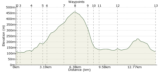
Ascent
360m (1181ft)
Descent
360m (1181ft)
Max. Elevation
470m (1541ft)
Altitude Gain & Loss
720m (2362ft)
Start & End
Bolton Abbey Village
Distance
15.20km
(9.44mi)
(9.44mi)
Duration
~5:15h
Difficulty
Moderate
Ordnance Survey Map
 2Created by mac.hawk on 08 Dec 2015
A circular walk in a very popular tourist area of Yorkshire. Most visitors don't stray from the river much but the route to Simon's Seat is popular with many people who wear a walking boots & the views from the trig pillar are outstanding.
Buses 72 & 72R from Ilkley & Skipton serve the area Mon to Sat. Dalesbus from Wakefield/Leeds on Sundays/ Bank Hols.
Walk Functions
Share
Nearby Walks
Addingham to Ilkley over Beamsley Beacon
A moderate, linear walk (countryside) starting in Bradford, England, about 15.80km (9.82 mi) long, duration: ~5:30h.Embsay Crag and Embsay Moor
A moderate, circular walk (low hills and fells (below 600m)) starting in North Yorkshire, England, about 10.80km (6.71 mi) long, duration: ~3:45h.Ilkley Amble
A leisurely, circular walk (countryside) starting in Bradford, England, about 9.10km (5.65 mi) long, duration: ~2:45h.Walk Map
- $walk->POI array(0)
Waypoints
OS Grid SE071539
The walk starts from Bolton Abbey Village Shop & Post Office (shop, tea rooms & toilets here). Pass through the famous 'hole in the wall' and head towards the Abbey ruins.
OS Grid SE073541
If you've never visited before it's worth taking a little time to view the Priory Church and the Abbey remains (technically the 'Abbey' was a Priory, but everyone knows it as 'Bolton Abbey').
About 0.26 km (~0.16 miles) from 
OS Grid SE075541
Cross the river via the footbridge (or stepping stones if the river is low enough to safely allow) and turn left to follow the river bank upstream for a mile to the footbridge at Cabendish Pavillion.
About 0.19 km (~0.12 miles) from 
OS Grid SE077553
At this point take the adjacent road and follow upstream for 1/4 mile - it starts to rise uphill halfway. Reach a wayposted track on the right (info board adjacent) and follow it.
About 1.25 km (~0.78 miles) from 
OS Grid SE077565
Follow the obvious path as it runs south of Porsforth Gill for 3/4 mile to descend to a footbridge over the stream in the Valley of Desolation. Continue right briefly, still following the stream.
About 1.18 km (~0.73 miles) from 
OS Grid SE080569
The path rises to reach a wall beyond which a wide track carries on ahead, uphill, through Sheepshaw Plantation. After 1/3 mile reach the open more and continue to follow the track ahead.
About 0.43 km (~0.27 miles) from 
OS Grid SE078585
Near the Rocking Stone reach a track coming in from the right, ignore and carry on ahead.
About 1.61 km (~1 miles) from 
OS Grid SE078597
The track soon veers left & after 1/4 mile turn right along the obvious track that heads towards Simon's Seat. From the trig pillar there are commanding views in all directions (weather permitting!).
About 1.25 km (~0.78 miles) from 
OS Grid SE068588
From the trig point take a path that heads south west, descending towards a wall on the right. Shortly after reaching the wall turn right down a defined track through woodland.
About 1.33 km (~0.83 miles) from 
OS Grid SE063591
The track meanders downhill to reach Howgill to then take a waymarked path directly ahead down towards the river.
About 0.57 km (~0.35 miles) from 
OS Grid SE059592
Reach the road at Stangs Lane and again continue ahead to (finally!) reach the River Wharfe and turn left. Follow the river bank for 1 1/4 miles to reach Barden Bridge.
About 0.41 km (~0.25 miles) from 
OS Grid SE050573
From Barden Bridge follow either bank of the river for 3 1/2 miles back to Bolton Abbey (my own preference is the west bank, as I believe you get better views of The Strid).
About 2.05 km (~1.27 miles) from 
 Bolton Abbey (2)
OS Grid SE071539
The walk is approx 12 miles and should be fine for energetic children.
About 4.01 km (~2.49 miles) from 

3 comments... join the discussion!
Janet
Changes to Wharfedale Bus Services from 5th September 2016 • Schoolday journeys on service 72A in Upper Wharfedale will be revised, with the last schoolday bus from Buckden to Grassington leaving at 16:20. • Pride of the Dales services 74 and 74S between Ilkley and Grassington will no longer operate on Mondays, Wednesdays or Fridays - see below for details of new service 74A. (The Saturday service continues unchanged). • NYCC service 75 between Grassington, Burnsall, Appletreewick and Hebden will no longer operate - see below for details of new service 74A. • A new NYCC service 74A will operate on Mondays and Wednesdays only between Ilkley, Bolton Abbey, Appletreewick, Burnsall, Grassington and Hebden. This will be provided by a 16 seater minibus. • DalesBus services run on Sundays and Bank Holidays in Wharfedale Summer and Winter. Timetables and further details of services into and within the Dales are available at www.DalesBus.org
Janet
New timetables from 11th April 2016 now in place for bus services from Ilkley and Skipton to Upper Wharfedale. Skipton to Grassington (Monday to Saturday); Grassington to Buckden (Monday to Saturday); Ilkley to Grassington (Monday, Wednesday, Friday, Saturday). In addition DalesBus services operate on Sundays and Bank Holidays. Full details at www.dalesbus.org
mac.hawk
NYCC cuts in subsidies for public transport will result in changes to the 72 & 72R services from April 2016. It is currently looking like a Skipton-Grassington service will continue Mon-Sat. Services from Ilkley to Grassington, along with all services from Grassington to Kettlewell/Buckden being on a demand responsive basis. See http://www.friendsofdalesbus.org.uk/#/latest-news/4590022137/North-Yorkshire-Bus-Subsidy-Cut-Proposals/10205989 for details.