The heart of the Downs
A strenuous walk (countryside) in national park South Downs starting and finishing in West Sussex, England, about 26.50km (16.47 mi) long with an estimated walking time of about 9:00h (1 overnight stay). It is suitable for families with children, but unsuitable for prams & pushchairs, wheelchairs.
Elevation Profile
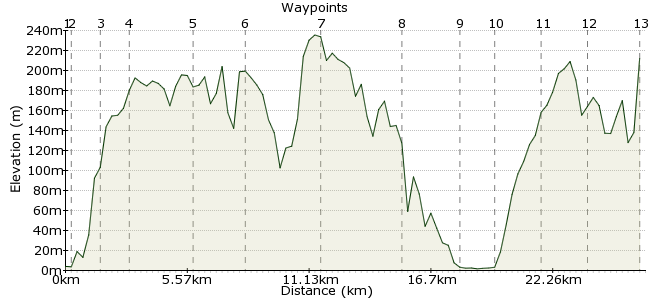
Ascent
443m (1453ft)
Descent
235m (770ft)
Max. Elevation
240m (787ft)
Altitude Gain & Loss
678m (2223ft)
Start
Amberley
End
Poynings
Distance
26.50km
(16.47mi)
(16.47mi)
Duration
~9:00h
Difficulty
Strenuous
Ordnance Survey Maps
This section is my favourite chunk of the South Downs. Not the most spectacular - that would have to be Seven Sisters and Beachy Head - but it's a stretch that puts you right out in the countryside, away from the sea (mostly) and in among the folds of the landscape. It can be done in a day but my tip would be to camp or stay at the YHA near Devil's Dyke and have a night walk along the downs.
Walk Functions
Share
Nearby Walks
Amberley, Burpham and North Stoke
A moderate, circular walk (countryside) starting in West Sussex, England, about 11.70km (7.27 mi) long, duration: ~3:45h.Around Amberley
A moderate, circular walk (countryside) starting in West Sussex, England, about 14.90km (9.26 mi) long, duration: ~4:45h.Arundel pub walk
A leisurely, circular walk (riverside) starting in West Sussex, England, about 5.30km (3.29 mi) long, duration: ~1:45h.Walk Map
- $walk->POI array(0)
Waypoints
OS Grid TQ025118
Take the train to Amberley, a small town on the northern side of the Downs.
OS Grid TQ027122
Pick up the South Downs Way right outside the station and head eastwards.
About 0.46 km (~0.29 miles) from 
OS Grid TQ038125
A short climb takes you onto the ridge for your first taste of proper Downland air.
About 1.12 km (~0.7 miles) from 
OS Grid TQ050125
The nice feature of this section is that there are paths and bridleways heading southwards into the downs, so you can mix things up a little should you wish.
About 1.21 km (~0.75 miles) from 
OS Grid TQ080122
Continue along to Chantry Hill, with views over Storrington.
About 3.02 km (~1.88 miles) from 
OS Grid TQ102119
Keep to the high ground for the next section too.
About 2.22 km (~1.38 miles) from 
OS Grid TQ137120
This ancient site near Findon is worth a little explore: www.mysteriousbritain.co.uk/england/west-sussex/featured-sites/chanctonbury-ring.html
About 3.47 km (~2.16 miles) from 
OS Grid TQ162094
The route veers southwards to curve around Steyning. At this point, I would pick up the Monarch's Way into Bramber to have a nose around Bramber Castle.
About 3.58 km (~2.22 miles) from 
OS Grid TQ186105
Another point of interest on route. Once explored, pick up the Downs Link to rejoin the main path.
About 2.60 km (~1.62 miles) from 
OS Grid TQ196092
Cross the river and get ready for the next climb.
About 1.62 km (~1.01 miles) from 
OS Grid TQ215101
There's a YHA here if you are looking for a rest stop.
About 2.10 km (~1.3 miles) from 
OS Grid TQ232110
A popular spot along the Downs.
About 1.94 km (~1.21 miles) from 
 Devil's Dyke
OS Grid TQ257109
Finish up at Devil's Dyke, another landmark of the Downs. Regular buses leave from here to Brighton station, where you can connect back to Amberley via the highly scenic coastal railway.
About 2.50 km (~1.55 miles) from 
