The Simonside hills
A strenuous walk (low hills and fells (below 600m)) in national park Northumberland in Northumberland, England, about 21.30km (13.24 mi) long with an estimated walking time of about 7:15h. It is suitable for families with children, but unsuitable for prams & pushchairs, wheelchairs.
Elevation Profile
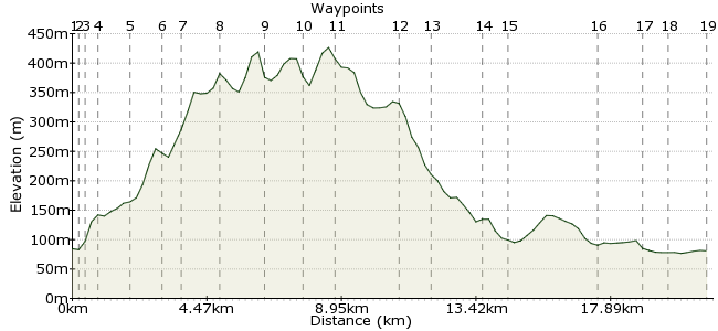
Ascent
365m (1197ft)
Descent
369m (1210ft)
Max. Elevation
430m (1410ft)
Altitude Gain & Loss
734m (2407ft)
Start & End
Rothbury
Distance
21.30km
(13.24mi)
(13.24mi)
Duration
~7:15h
Difficulty
Strenuous
Ordnance Survey Maps
The Simonside hills are steeped in legend. Tales abound of fairy folk and little people in these hills. Even if you don't spot them, you can have a memorable day out striding the hills and enjoying some stunning Northumberland scenery. There are regular buses from Morpeth.
Walk Functions
Share
Nearby Walks
Amble to Alnmouth
A moderate, linear walk (coast) starting in Northumberland, England, about 10.40km (6.46 mi) long, duration: ~3:00h.Dunstanburgh castle and the Northumberland coast
A moderate, linear walk (coast) starting in Northumberland, England, about 11.30km (7.02 mi) long, duration: ~3:15h.The lower tors of the Cheviots
A moderate, circular walk (low hills and fells (below 600m)) starting in Northumberland, England, about 18.90km (11.74 mi) long, duration: ~7:00h.Walk Map
- $walk->POI array(0)
Waypoints
OS Grid NU058018
Take the bus to Rothbury.
OS Grid NU059015
Cross the river at Bridge Street.
About 0.25 km (~0.16 miles) from 
OS Grid NU058014
At the t-junction, pick up the St Oswald's Way.
About 0.16 km (~0.1 miles) from 
OS Grid NU057010
Pass through Whitton on the edge of town.
About 0.38 km (~0.24 miles) from 
OS Grid NU053000
The path heads into the countryside past Whittondean.
About 1.11 km (~0.69 miles) from 
OS Grid NZ052992
Pass through the fort and settlement on Garleigh Moor.
About 0.82 km (~0.51 miles) from 
OS Grid NZ050985
Just over the road, take the path on the right-hand side.
About 0.68 km (~0.42 miles) from 
OS Grid NZ037985
This path takes you over the beautiful Simonside Hills, starting with Dove Crag.
About 1.32 km (~0.82 miles) from 
OS Grid NZ024986
Continue over Simonside.
About 1.34 km (~0.83 miles) from 
OS Grid NZ013990
Pass through the gap between the patches of woodland.
About 1.11 km (~0.69 miles) from 
OS Grid NZ004982
Take the path over to Tosson Hill, the high point of the day at 440m.
About 1.19 km (~0.74 miles) from 
OS Grid NY986973
Descend down to Whitefield Hill and take the track, heading northwest.
About 1.99 km (~1.24 miles) from 
OS Grid NY979981
Continue past the cairn.
About 1.06 km (~0.66 miles) from 
OS Grid NY987996
Drop into Coquetdale and take the track overlooking the river.
About 1.69 km (~1.05 miles) from 
OS Grid NT995002
At Bickerton, drop down to the waterside.
About 1.00 km (~0.62 miles) from 
OS Grid NU021015
At Ryehill, you can head into Thropton, where you can pick up the same bus that runs to Rothbury.
About 2.87 km (~1.78 miles) from 
OS Grid NU034009
Otherwise, continue along to Summerville.
About 1.40 km (~0.87 miles) from 
OS Grid NU042012
Cross the river and head into town.
About 0.90 km (~0.56 miles) from 
 Riverside path
OS Grid NU056015
Follow the river back into Rothbury.
About 1.38 km (~0.86 miles) from 
