Packhorses, Peat and Peewits
A moderate walk (low hills and fells (below 600m)) in national park Peak District in Derbyshire, England, about 11.40km (7.08 mi) long with an estimated walking time of about 4:15h. It is unsuitable for families with children, prams & pushchairs, wheelchairs.
Elevation Profile
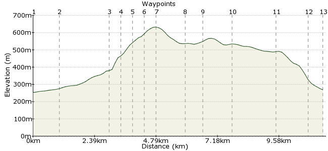
Ascent
389m (1276ft)
Descent
374m (1227ft)
Max. Elevation
640m (2099ft)
Altitude Gain & Loss
763m (2503ft)
Start & End
Barber Booth
Distance
11.40km
(7.08mi)
(7.08mi)
Duration
~4:15h
Difficulty
Moderate
Ordnance Survey Map
 3Created by John Walker on 04 Dec 2016
This walk starts from Barber Booth, just a group of houses and a chapel. It has self-catering accommodation and camp sites and is close to the train station at Edale, just a 15 minute walk away along the Noe valley. The walk heads up to join the Pennine Way, up Jacob's Ladder to the edge of Kinder Plateau. Retracing the route to cross Brown Knoll then back to the start down Chapel Gate Track.
Walk Functions
Share
Nearby Walks
Shivering Mountain
A moderate, circular walk (low hills and fells (below 600m)) starting in Derbyshire, England, about 9.30km (5.78 mi) long, duration: ~3:30h.Up the Clough
A leisurely, circular walk (low hills and fells (below 600m)) starting in Derbyshire, England, about 7.60km (4.72 mi) long, duration: ~3:00h.Edale to Hope via Kinder and Alport Castles
A moderate, linear walk (low hills and fells (below 600m)) starting in Derbyshire, England, about 19.70km (12.24 mi) long, duration: ~7:45h.Walk Map
- $walk->POI array(0)
Waypoints
OS Grid SK113847
From the cluster of houses which is Barber Booth go down the road cross over the River Noe, turning right just beyond the bridge, sign-posted to Upper Booth. The road stays close to the river.
OS Grid SK103850
The road ends next to a farm where the Pennine Way arrives from Edale (the official start, just a mile or so away). Follow the Pennine Way ahead up a wide track past Lee House Farm with its NT barn.
About 1.03 km (~0.64 miles) from 
OS Grid SK088861
The next gate takes you across a packhorse bridge into the Kinder Scout National Nature Reserve and the track sets off on a longish stone-stepped climb, Jacob's Ladder, first of many paved sections.
About 1.85 km (~1.15 miles) from 
OS Grid SK084862
At the top of the ladder the path continues upwards on a stony section, down which small streams choose to run after wet weather.
5. You finally reach a fork in the path. We took the right hand pa
About 0.46 km (~0.29 miles) from 
OS Grid SK080862
You reach a fork in the path. We took the right hand path leading past the first major rock outcrop, Swines Back. Continue on the sometimes slabbed path to the next big outcrop, Edale Rocks.
About 0.39 km (~0.24 miles) from 
OS Grid SK079866
Here begins the Kinder Plateau. Beyond lie several cairns before you reach the trig point at Kinder Low at an altitude of 635m. Ahead is Kinder Scout, the site of the famous Mass Trespass of 1932.
About 0.49 km (~0.3 miles) from 
OS Grid SK078870
The trig point was a suitable goal so we turned round on reaching it, going down to Swines Back, then continuing South on a newly slabbed path across open dark peat-covered country towards Brown Knoll
About 0.38 km (~0.24 miles) from 
OS Grid SK081859
One or two paths are marked on the OS map but recent renovation work has installed paved sections running parallel but not on the same alignment. Look out for the paved sections to avoid boggy ground
About 1.12 km (~0.7 miles) from 
OS Grid SK080853
You reach another trig point here at Brown Knoll. 10. As usual the haunting sounds of curlews were all around but we never saw one in flight or on the ground. We did see plenty of lapwings and grouse.
About 0.63 km (~0.39 miles) from 
OS Grid SK088845
As you cross Horsehill Tor the views across to the long ridge to the south begin to dominate, the narrow ridge rising to a sequence of peaks with the hillfort at Mam Tor most prominent.
About 1.09 km (~0.68 miles) from 
OS Grid SK097832
Some 200 m before the path goes left up Rushup Edge there is a simple pole beside the path which marks the left turn to follow Chapel Gate track back down to Barber Booth, leaving the peat behind.
About 1.63 km (~1.01 miles) from 
OS Grid SK106840
As you draw level with the railway tunnel entrance there is a gate across the path where you leave the National Park. Almost immediately a stile on the left leads down across fields and several stiles
About 1.22 km (~0.76 miles) from 
 Manor House Farm
OS Grid SK110845
Go to the left of Manor House Farm, to emerge onto the road by the river Noe. Turn right to return to Barber Booth.
About 0.59 km (~0.37 miles) from 

3 comments... join the discussion!
John Walker
Fair point, Edale station is 15 min walk from Barber Booth but the throbbing heart of Grindsbrook Booth (aka Edale) is almost as far from Edale station as Barber Booth is! We walked with our kit from Edale station to Barber Booth, where we stayed, so for us it was a car free walk. And that's where the gps track for this walk begins and ends.
Timwoods
To be fair it does say in the walk details that it is a 15-minute walk from the station, and perhaps the walk submitter wanted to highlight the facilities in Barber Booth to lighten the load on Edale, which can get a bit overwhelmed at times. Either way, I think it still counts as a car-free walk, albeit slightly longer than the map shows.
Mac.Hawk
Public transport to Barber Booth is effectively NIL and realistically this route is from Edale railway station - add about 1 mile each way if you simply go by road from/return to such.
Why write a 'Car Free Walk' from a non public transport start/finish point ????
Why not simply start the walk from Edale??????