Ladybower, Win Hill & Hope
A leisurely walk (low hills and fells (below 600m)) in national park Peak District starting and finishing in Derbyshire, England, about 9.00km (5.59 mi) long with an estimated walking time of about 3:15h. It is suitable for families with children, but unsuitable for prams & pushchairs, wheelchairs.
Elevation Profile
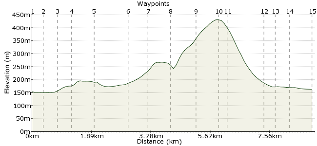
Ascent
279m (915ft)
Descent
269m (882ft)
Max. Elevation
440m (1443ft)
Altitude Gain & Loss
548m (1797ft)
Start
Bamford
End
Hope
Distance
9.00km
(5.59mi)
(5.59mi)
Duration
~3:15h
Difficulty
Leisurely
Ordnance Survey Map
 3Created by John Walker on 22 Dec 2016
This is a Peak District walk of many parts, combining moderately steep moorland with forest walking and a stroll from the Ladybower reservoir dam along the lakeside. The walk starts at Bamford station and ends at the neighbouring station of Hope, on the Manchester to Sheffield rail line via Edale. Hope is well provided with rest stops, cafes and pubs and is well used to muddy boots.
Walk Functions
Share
Nearby Walks
Ladybower from Bamford via High Neb
A moderate, circular walk (low hills and fells (below 600m)) starting in Derbyshire, England, about 18.70km (11.62 mi) long, duration: ~6:30h.Across the Divide - Hope to Edale
A leisurely, linear walk (low hills and fells (below 600m)) starting in Derbyshire, England, about 8.60km (5.34 mi) long, duration: ~3:15h.Stanage Edge, Carl Wark and Higger Tor
A moderate, circular walk (low hills and fells (below 600m)) starting in Derbyshire, England, about 11.90km (7.39 mi) long, duration: ~4:15h.Walk Map
- $walk->POI array(0)
Waypoints
OS Grid SK207825
Leave Bamford train station from the northern platform and go left along a lane until you meet a main road. Turn right here and follow the pavement on the right hand side of this busy road.
OS Grid SK205828
After 250m cross over to follow a paved road left, immediately crossing the River Derwent, flowing down from the Ladybower dam. Continue on this track past small businesses then between fields.
About 0.40 km (~0.25 miles) from 
OS Grid SK201830
3. You join another track coming from the south at an imposing Victorian villa, now a Quaker Centre. Turn right just beyond here to take a narrow path between trees.
About 0.48 km (~0.3 miles) from 
OS Grid SK200834
A path from the left merges, shortly. Take the right fork up a paved lane, part of the Derwent Valley Path, possibly an old railway line, along a level contour above the flat bottomed Derwent valley.
About 0.40 km (~0.25 miles) from 
OS Grid SK197840
The track descends to cross a minor road then goes back onto its tree-lined embankment
About 0.67 km (~0.42 miles) from 
OS Grid SK197850
In 1km the wide and immaculately-clipped grassy bank of the Ladybower reservoir dam emerges through the woodland & the path gradient picks up to deliver you at a point level with the top of the dam
About 1.04 km (~0.65 miles) from 
OS Grid SK197855
Continue beside the water to the left of the dam. The path climbs steadily into trees, continuing through mixed woodland, an attractive camouflage for the conifer plantation ranged up the hill.
About 0.53 km (~0.33 miles) from 
OS Grid SK191860
Stay on the lakeside as the path rounds a wide bend. Then take a signed footpath going up the hillside to join a wider path going diagonally right up the hill to enter a dark world of tall conifers
About 0.75 km (~0.47 miles) from 
OS Grid SK187854
On leaving the wood an official metal signpost shows the route. Our path leaves the right hand track some way along from the sign, going diagonally left uphill to the saddle point, right of Win Hill
About 0.74 km (~0.46 miles) from 
OS Grid SK182850
Where our track meets a wide crossing path, go ahead through a metal gate to descend diagonally across rough pasture to another gate.
About 0.67 km (~0.42 miles) from 
OS Grid SK181848
An even steeper smoother hillside brings you down to a gate in a wall at Twitchill Farm. Go left across the farmyard to a tarmac path heading down towards the railway line and Hope village beyond.
About 0.23 km (~0.14 miles) from 
OS Grid SK172842
At the foot of the fields, just before the tracks go right, alongside the rails descending to cross via an underpass. Then follow this path to cross the River Noe on the pretty stone Kilnhill Bridge
About 1.05 km (~0.65 miles) from 
OS Grid SK171838
Go left into Edale Rd. which leads past a school and various shops to the main street of Hope with several pubs, cafes and small shops for refreshments, all of which apparently welcome dirty boots.
About 0.38 km (~0.24 miles) from 
OS Grid SK171835
After enjoying the village's delights Hope train station is around a 15 minute walk from here, going left along the A6187 (it's a busy main road with heavy lorries but has a pavement along one side)
About 0.36 km (~0.22 miles) from 
 Hope station
OS Grid SK178831
When you have left all Hope behind take the second left to the station. It has services every two hours to both Manchester and Sheffield. So it's wise to consult the timetable before you reach here.
About 0.71 km (~0.44 miles) from 
