The River Great Ouse and Roswell Pits
A leisurely walk (riverside) in Cambridgeshire, England, about 4.20km (2.61 mi) long with an estimated walking time of about 1:15h. It is suitable for families with children, prams & pushchairs, but unsuitable for wheelchairs.
Elevation Profile
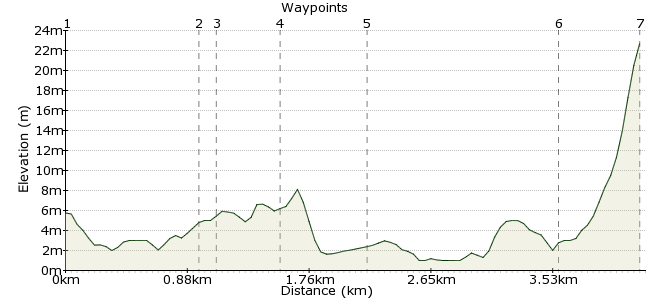
Ascent
24m (78ft)
Descent
7m (22ft)
Max. Elevation
30m (98ft)
Altitude Gain & Loss
31m (100ft)
Start & End
Ely station (or Market Street bus stop, Ely)
Distance
4.20km
(2.61mi)
(2.61mi)
Duration
~1:15h
Difficulty
Leisurely
Ordnance Survey Map
The walk takes you beside the River Great Ouse from the town, along an ancient track to three flooded claypits; a rural retreat within a mile of the city centre. Two of the Pits are a Wildlife Trust Nature Reserve where great crested grebe and tufted duck are usually seen and bittern and otter have been reported. The view of Ely Cathedral from Roswell Pits is amongst the best in Ely. (If arriving by bus start at the Cathedral, and turn left when you reach the river.)
Walk Functions
Share
Nearby Walks
The Hundred Foot Washes
A strenuous, circular walk (countryside) starting in Cambridgeshire, England, about 23.40km (14.54 mi) long, duration: ~7:00h.Littleport to Ely along the River Cam
A moderate, linear walk (riverside) starting in Cambridgeshire, England, about 9.70km (6.03 mi) long, duration: ~2:45h.Cambridge to Grantchester
A moderate, circular walk (riverside) starting in Cambridgeshire, England, about 10.20km (6.34 mi) long, duration: ~2:45h.Walk Map
- $walk->POI array(0)
Waypoints
OS Grid TL542794
Start of the walk
Turn left out of the station approach, cross the road at the pedestrian lights, go straight on at the roundabout and take the first on the right which takes you to the river and the Cutter Inn. follow the riverbank to your left passing Jubilee Gardens and the Maltings..
OS Grid TL548801
The name comes from the area's use as watercress beds.Since then it has been a council tip and a hockey pitch. It is now an area for informal recreation. Take the path on your left and cross the park to steps and a slope which take you into Springhead Lane.
About 1.00 km (~0.62 miles) from 
OS Grid TL548803
Turn right along the ancient track thought to be the medieval route from the river into Ely. Look out for a wide variety of small birds and the occasional sparrowhawk. Take a path on the left to the edge of the newest of the three pits which make up Roswell Pits. Keep the pit on your left.
About 0.10 km (~0.06 miles) from 
OS Grid TL552805
Turn right up the road to where you can see Ely Cathedral over the new pit. The sailing pit, the largest of the three pits is currently under threat. More information is at elywildspaces.org.uk. Go back down the road over the level crossing passing buildings and a compound.
About 0.50 km (~0.31 miles) from 
OS Grid TL557805
A good place to see a kingfisher, ducks swans and grebes. Retrace your steps to the carpark and take the path on the left towards the river. turn right along a raised bank through washland where barn owls hunt at dusk. Go under the railway bridge and continue to Peacock's Tearoom.
About 0.51 km (~0.32 miles) from 
OS Grid TL545799
from here you can continue along the river back to the station or take a detour to the historic city centre by turning right up Waterside and Forehill to Market Square. Go straight on along High Street then turn left to the Cathedral and Stained Glass Museum or Straight on to Tourist Information
About 1.34 km (~0.83 miles) from 
 Ely Cathedral
OS Grid TL540799
From the west door continue along the Gallery then turn left through an arched gateway, the Porta and follow the path through Cherry Hill Park to Broad Street. Cross over the road and walk through Jubilee Gardens to the river and back to the station.
About 0.51 km (~0.32 miles) from 

1 comment... join the discussion!
Helen
The paths along Springhead Lane and the river have been resurfaced recently so the route is now passable for wheelchairs but you might find it hard going to go up Forehill into the town centre.