Cross O'Greet to Bowland Knotts Circular
A leisurely walk (countryside) in Lancs, England, about 9.70km (6.03 mi) long with an estimated walking time of about 4:15h. It is unsuitable for families with children, prams & pushchairs, wheelchairs.
Elevation Profile
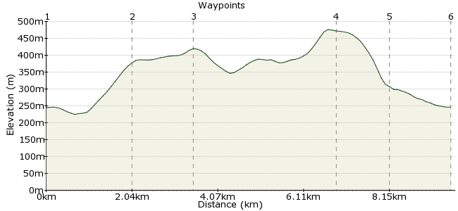
Ascent
472m (1548ft)
Descent
473m (1551ft)
Max. Elevation
480m (1574ft)
Altitude Gain & Loss
945m (3099ft)
Start & End
Clapham cum Newby, Craven, North Yorkshire, England
Distance
9.70km
(6.03mi)
(6.03mi)
Duration
~4:15h
Difficulty
Leisurely
Ordnance Survey Map
This satisfying half-day hike starts from either Bowland Knotts, Cross o’ Greet or Cross o’ Greet Bridge and can comfortably be completed from either the Bentham or Clitheroe direction on the 833 Bowland Explorer service.
With careful planning, it could be extended to include a diversion to Stocks Reservoir, or even a complete loop of this pretty upland oasis for the fleet of foot.
This route description starts from Cross o’ Greet Bridge and follows the route in a clockwise direction.
Walk Functions
Share
Nearby Walks
The Forest of Bowland
A strenuous, circular walk (moorland) starting in Lancashire, England, about 23.00km (14.29 mi) long, duration: ~7:30h.Clapham to Horton via Crummack Dale
A moderate, linear walk (low hills and fells (below 600m)) starting in North Yorkshire, England, about 11.80km (7.33 mi) long, duration: ~4:15h.A walk around Whitendale
A moderate, circular walk (low hills and fells (below 600m)) starting in Lancashire, England, about 15.90km (9.88 mi) long, duration: ~5:30h.Walk Map
- $walk->POI array(0)
Waypoints
OS Grid SD702589
The Board House, Ribble Valley, Lancs, England - Follow faint path east across boggy tussock grass above the infant River Hodder through sheepfolds and cross the Kearsden Brook to reach a track then footpath on left that climbs NE past farm buildings and a lonely barn on the fell side.
OS Grid SD700605
As the gradient levels off, take a sharp left turn through gate where the dry stone walls meet then follow rough track northeast towards the craggy outcrops of Bowland Knotts.
About 2.04 km (~1.27 miles) from 
OS Grid SD726606
Join the road and climb briefly north over the cattle grid then 90 degrees left at the rough parking area, following the rocky ridge SW towards the Trig Point on the most prominent outcrop. Continue W, descending first, then climbing past the remote outcrops of Cold Stone and Ravens Castle.
About 1.32 km (~0.82 miles) from 
OS Grid SD693612
Head left along the wire fence descending steadily over boggy peat hags to reach the road at Cross o’ Greet. Descend SE down the road for half a mile then follow one of the faint paths down to the stream and ford with care.
About 3.34 km (~2.08 miles) from 
OS Grid SD692600
Continue along far bank climbing to the hidden abandoned quarry at SD 694 596 where you’ll find a rusting steam crane and the remains of a narrow gauge railway used to transport stone for the construction of the dam that created Stocks Reservoir in the 1930s. Continue SE to Cross o’ Greet Bridge.
About 1.21 km (~0.75 miles) from 
 Done! The finish of the walk
OS Grid SD702589
The Board House, Ribble Valley, Lancs, England
About 1.47 km (~0.91 miles) from 
