St Michael's Way
A leisurely walk (low hills and fells (below 600m)) starting and finishing in Cornwall, England, about 9.70km (6.03 mi) long with an estimated walking time of about 3:15h. It is unsuitable for families with children, prams & pushchairs, wheelchairs.
Elevation Profile
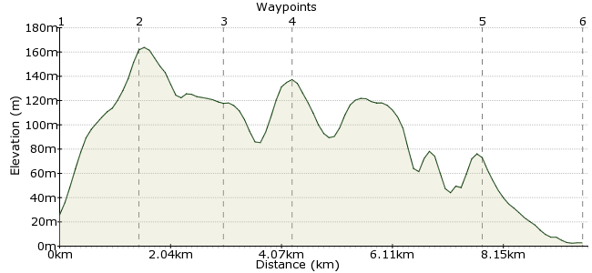
Ascent
159m (521ft)
Descent
182m (597ft)
Max. Elevation
170m (557ft)
Altitude Gain & Loss
341m (1118ft)
Start
St Ives
End
Marazion
Distance
9.70km
(6.03mi)
(6.03mi)
Duration
~3:15h
Difficulty
Leisurely
Ordnance Survey Map
Cross country route from St Ives to Marazion taking in Knill's Monument, Trencrom Hill and St Michael's Mount. Can be done in either direction, largely well-signposted, overgrown in a few places, and there is the option to add an extra 3 miles at the south end by walking to Penzance from Marazion along the coast path. Start is from St Ives bus/train station going east along the coast path. Buses run from Marazion back to St Ives or to Penzance and also from Penzance to St Ives.
Walk Functions
Share
Nearby Walks
The Zennor Coastal Circular
A leisurely, circular walk (coast) starting in Cornwall, England, about 6.00km (3.73 mi) long, duration: ~2:00h.From Zennor to Morvah on the Cornish coast
A leisurely, linear walk (coast) starting in Cornwall, England, about 7.40km (4.60 mi) long, duration: ~2:15h.Marazion to Praa Sands
A leisurely, linear walk (coast) starting in Cornwall, England, about 7.70km (4.78 mi) long, duration: ~2:15h.Walk Map
- $walk->POI array(0)
Waypoints
OS Grid SW519401
Start of the walk
OS Grid SW516386
18th century monument erected by John Knill. Great views of both St Ives and across to St Michael's Mount.
About 1.49 km (~0.93 miles) from 
OS Grid SW524372
nr Trevarrack
About 1.57 km (~0.98 miles) from 
OS Grid SW520361
Fort owned by National Trust
About 1.17 km (~0.73 miles) from 
OS Grid SW505330
Small village en route to Marazion
About 3.48 km (~2.16 miles) from 
 Marazion Marsh
OS Grid SW512312
Wetland reserve for wild birds
About 1.89 km (~1.17 miles) from 
