Ben Arthur (The Cobbler) and Beinn Narnain
A moderate walk (mountain (above 600m)) in Argyll and Bute, Scotland, about 10.60km (6.59 mi) long with an estimated walking time of about 6:15h. It is unsuitable for families with children, prams & pushchairs, wheelchairs.
Elevation Profile
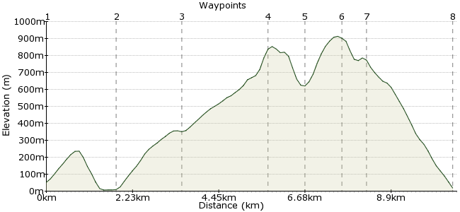
Ascent
1106m (3628ft)
Descent
1140m (3740ft)
Max. Elevation
920m (3018ft)
Altitude Gain & Loss
2246m (7368ft)
Start & End
Arrochar and Tarbet train station
Distance
10.60km
(6.59mi)
(6.59mi)
Duration
~6:15h
Difficulty
Moderate
Ordnance Survey Map
Ben Arthur - also known as The Cobbler - is one of Scotland's most famous and recognisable peaks. It gets its nickname because its three summits look like a cobbler working (to some people at least). This route also takes in the oft-neglected Munro of Beinn Narnain as well.
Public transport is reliable but irregular - there is a train station between Arrochar and Tarbet, or use the '950 Lomond Ring'n'Ride' bus:
www.spt.co.uk/bus/service950.html
Walk Functions
Share
Nearby Walks
Arrochar's Munros - Beinn Narnain, Beinn Ime and Ben Vane
A strenuous, circular walk (mountain (above 600m)) starting in Argyll and Bute, Scotland, about 18.40km (11.43 mi) long, duration: ~10:00h.Ben Lomond Hike: using train and ferry
A moderate, circular walk (mountain (above 600m)) starting in Argyll and Bute, Scotland, about 9.80km (6.09 mi) long, duration: ~5:30h.Through the Arrochar Alps
A strenuous, linear walk (mountain (above 600m)) starting in Argyll and Bute, Scotland, about 20.30km (12.61 mi) long, duration: ~12:45h.Walk Map
- $walk->POI array(0)
Waypoints
OS Grid NN312044
Start of the walk. There is a path behind the train station that takes you along a forest track - nicer than traipsing along the road round to Succoth.
OS Grid NN295053
From Succoth village, you will see signs to Ben Arthur. Take one of these leading uphill through the forest.
About 1.82 km (~1.13 miles) from 
OS Grid NN279051
The path heads up along the burn running between Ben Arthur and Beinn Narnain. At the dam, head west towards Ben Arthur.
About 1.69 km (~1.05 miles) from 
OS Grid NN259058
The summit! At 884m, it's a little way under Munro height (914m) but nothing can take away from the spectacular views from this stunning mountain. Keep your eyes peeled as well - on one visit here, I saw a pair of golden eagles swoop past!
About 2.11 km (~1.31 miles) from 
OS Grid NN264064
Head across the summit to the North Peak, then drop down to the pass between Ben Arthur and Beinn Narnain.
About 0.86 km (~0.53 miles) from 
OS Grid NN272067
This summit is often overlooked by people flocking to the more picturesque 'Cobbler' but it is worth extending the day to take in this summit too - it's also a Munro, at 926m. The path heads to the summit via the northwestern flank.
About 0.92 km (~0.57 miles) from 
OS Grid NN276063
From Beinn Narnain, follow the path heading southeast back towards Succoth, which heads over Cruach nam Miseag and drops steeply downhill and back through the forest.
About 0.53 km (~0.33 miles) from 
 Back to Succoth
OS Grid NN295051
Follow the same route you came back to the train station (or bus stop). If you are planning to stay the night (or train times demand it) then there are campsites in Arrochar and Succoth. Arrochar is your best bet for a few beers as well - with great views across Loch Long of the day's walk.
About 2.23 km (~1.39 miles) from 

2 comments... join the discussion!
Timwoods
Thanks Simona, a road walk at the end of the day not ideal! Bus timetables for the route can be found here (route 302): http://www.garelochheadcoaches.co.uk/ Only two a day, but handily timed to fit around a day walk! Until the route is reopened, then my tip (if time allows) would be to camp overnight in Succouth/Arrochar. It's very peaceful to wander by the loch in the evening.
Simona
Hi, great walk, went to hike it last week, just one thing, the path behind the train station is closed for reconstruction till 2018, so you have to actually go all the way to Arroth along the road. I suggest you take the bus as it was a pain, especially on the way back when I was really tired.